LOCAL SURVEY
Contents
:- Introduction 2
.1:- Background 2
.2:- The Council 3
.3:- Aims 3
2:- Site details 4
2.1:- Proposed site 4
2.2:- Access 4
2.3:- Topography 4
3:- Policies 5
3.1:- Site specific 5
3.2:- Local 5
3.3:- National 8
3.4:- International 8
4:- Good practice guidance 9
5:- Design 9
5.1:- Objectives 9
5.2:- Guidance 10
6:- Observations 11
7:- Preliminary environmental impact assessment 12
7.1:- Mitigating measures 14
8:-Appendix 14
8.1:- Health and safety 14
8.2:- Fire protection 15
8.3:- Further guidance 15
8.4:- Site photographs 17
9:- Local proposals map
:- INTRODUCTION
Briggs & Mortar have commissioned Spencer Property to carry out a local survey for land in Withernsea, which could be used for their latest project. The inspection was carried out on 9th February 2004, by Mr Whiteley.
Brief
a. Identify a suitable site for mixed-use development, including appropriate supporting local plan policies, whether they are site specific or general.
b. Give appropriate design guidance, including policy guidance, good practice guidance, and on-the-ground observations.
c. Assess the likely environmental impact of the development in preparation for the expected request for an Environmental Impact Assessment.
1.1:- Background
Withernsea is an urban centre serving the southeast of the borough, situated approximately 22 miles east of Hull and lying at the junction of the A1033 trunk road and the B1242 distributor road. Regular bus services between Hull and Withernsea provide public transport along the A1033. The A1033 and the B1445 are important commuter roads, which access major developments such as Saltend chemical works and the gas terminals at Easington.
The main north axis of the town is Queen Street, with a well-defined retail area, along which most of the shops and services are located. To the south and west of the town centre, newer suburban development has taken place at lower densities. The high-density development in the central area emphasises the lack of open spaces and trees. Future developments of large sites in the town will need to incorporate proposals for landscaping and open space provision.
In the older part of the town, the street pattern forms a grid network with long terraces of early 20th century housing. To the south and west of the town centre, newer suburban development has taken place at lower densities. Withernsea has a wide range of services and facilities associated with a town of this size.
The industrial area of the town on Hull Road consists of a small estate of workshop units of various sizes.
The surrounding countryside is generally of an open nature and classified by the Ministry of Agriculture, Fisheries and Food (MAFF) as being of Grades 2/3 agricultural quality. There are few topographical features constraining development other than the eroding coastline along its eastern boundary.
.2:- The Council
East Riding County Council (ERCC) as a representative body exists to maximise the well-being of the people of the borough. A healthy and sustainable environment is fundamental to the well-being of the borough both now and for the long-term future. The Council has given an undertaking to work to improve and protect the environment. It will improve the appearance and cleanliness of the borough for the benefit of the local people, visitors and potential investors. Local guidance, in the form of the Local Plan, Economic Development Plan and the Joint Structural Plan stress the importance of good design in the development of an attractive built environment.
ERCC is helping to protect and encourage investment and to create a better living environment by adopting better design practice as detailed in Planning Policy Guide (PPG12), Regional Planning Guide (RPG 12) and taking on board the recommendations of the Urban Task Force findings.
.3:- Aims
To give practical effect to the principles of PPG1, the local plan & economic strategy, thereby achieving high quality development in the built environment by delivering the following specific aims:
* To achieve & maintain sustainable developments involving the prudent use of natural resources.
* To achieve & maintain innovative developments which benefit from contemporary solutions whilst respecting and responding to the character of the borough.
* To achieve & maintain attractive integration of development thereby minimizing the impact of development on the local and wider communities.
* To achieve & maintain attractive places which minimizes the opportunity for crime and the fear of crime thereby encouraging social and community activity.(1)
2:- Site details
2.1 Proposed site
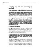
A suitable site for mixed-use development in Withernsea has been identified; the land is situated at Carrs Meadow, west of Kirkfield Road / Ryecroft Drive, 7.41 Ha (18.31 acres). There is potential to build up to 160 dwellings on the site.(2)
View north
2.2:- Access
The site is neighboured by good quality farmland, which may cause concerns to local farmers. Measures to mitigate potential adverse impacts of the proposed project will be expedited once planning consent is approved.
2.3:- Topography
The site slopes gently upward towards the northeast to a low ridge. The total elevation difference from northeast to southwest is about 100 feet. The site is near or alongside good quality (grade 2) agricultural land. To the south of the proposed site runs the former east coast railway-line, which would support good access to the site, with minimum disruption to farmland.
View south
3:- Policies
3.1 Site specific
A comprehensive scheme is required, which can allow phased development. Proposals should incorporate mixed housing styles and servicing provision for the prospective new school site, and can include local shopping and community facilities. A landscape scheme designed to enhance nature conservation interests is required to the site's western and southern boundaries adjoining the recreational cycle/footpath on the former railway line/cycleway and to the golf course extension. A pedestrian footpath should link the development to the former railway line.
4.2:- Local policy
ERCC has adopted the principles of Agenda 21, central to this is a commitment to work towards sustainable development. Anyone planning to develop or use land in the borough, from household extensions to major building schemes, has a responsibility to ensure the change will protect the environment. As regards planning and building control applications, ERCC takes into account, wherever possible, the potential contribution of a new development, or change of use, to both environment and neighbourhood.
An analysis of ERCC local development plan has identified key areas in which new development proposals ...
This is a preview of the whole essay
4.2:- Local policy
ERCC has adopted the principles of Agenda 21, central to this is a commitment to work towards sustainable development. Anyone planning to develop or use land in the borough, from household extensions to major building schemes, has a responsibility to ensure the change will protect the environment. As regards planning and building control applications, ERCC takes into account, wherever possible, the potential contribution of a new development, or change of use, to both environment and neighbourhood.
An analysis of ERCC local development plan has identified key areas in which new development proposals must adhere.
Site and layout
* The proposed site may have conservation issues that have to be adhered to, for instance the site has hedgerows growing along the western boundary. These hedgerows are protected by law and permission for their removal is required. All hedgerows removed, must be replaced.
* Measures to conserve existing landforms, watercourses, vegetation and wildlife habitat must be incorporated as positive elements in the design scheme. Trees can be killed by changes in the water table and wetlands and watercourses may dry up.
* Active efforts must be made to maintain or create links between the green spaces on the site and those adjoining or nearby, to assist wildlife movement.
* An assessment of the likely impact of the road and service networks on the site and the surrounding area must be carried out.
* Contact must be made with the council's historic buildings department, as there are a number of 17th century buildings near to the site, which may be affected by the site's transport movements.
* Does the density of the development strike a good balance between efficient land usage and amenity for the occupants?
Fight Pollution
* The development must be made easily accessible by public transport.
* Provisions should be made as part of the development to improve public transport access.
* The development must be easily and safely accessible on foot or bicycle; a 'Green Commuter Plan' is to be submitted with the proposals.
* Parking areas are to be arranged to avoid water run-off into the watercourse.
Building Design
* The design must make a positive visual contribution to the site and to adjacent areas. Respect for the character of the area and adjoining properties, particularly where these are listed or in conservation areas, must be considered.
* Measures to incorporate wildlife habitats within the design of the buildings, e.g. nesting lodges, should be considered.
* The design scheme should cut opportunities for crime and provide an environment where people feel safe to walk, cycle and play.
* Measures should be taken to minimise heat loss and maximise solar gain by sizing windows according to the direction of the building. The height of the building should be similar to those around it to prevent heat loss by exposure and to reduce energy demands.
* Considerations for optimal thermal performance should be incorporated. Building Regulations are the minimum standards to aim at.
* Plans must comply with the current light pollution regulations. Light can be a pollutant if excessive use is a disturbance to other people.
Landscaping
* Consider how to incorporate the habitat requirements of birds, insects and mammals.
* The design should have positive contribution to the visual and/or recreational amenity of the site.
* Consider making full use of climbing plants to soften walls, fences and buildings.
* Adapt or modify the landscaping design to ensure the preservation of any land drainage ditches.
Sustainable materials
Materials used in development should not have an adverse impact on the wider environment through their production, toxicity, durability and recycling potential. The council will encourage developers to use sustainable materials, which can be defined as materials that:
* have been produced with low energy input (such as sustainably produced timber);
* have low maintenance needs;
* are not produced using toxic processes or result in toxic materials;
* are locally manufactured or recycled.
For information on sustainable materials, see Handbook of Sustainable Buildings (James and James Limited)
Drainage
* Install interceptors in the drainage system to prevent petrol, oil and other pollutants from washing into nearby watercourses and ponds.
Construction
* Tree work is preferred to be left until the winter.
* Avoid work, which affects animals during the spring breeding season. It is an offence to disturb badgers, bats and birds.
* Car parks, site office and storage areas should be positioned to cause minimum damage and disturbance to the site.
* Do not deny wildlife access to and from their homes and foraging areas.
Chemicals and hazardous material
* A site investigation should be carried out to identify areas of soil contamination.
* If weed-killers or fertilisers are used, specify the type to be used. For more information, contact The Pesticide Trust.
* Proper storage of diesel and bottled gas is required.
* Lead-free solders should be specified for drinking water supply pipe-work.
Conserve natural resources
* The design must pay due regard to the existing natural features of the site.
* The design is to take full advantage of the opportunities for enhancing the nature conservation value of the site.
* A management/maintenance plan for the 'green' elements of the site must be drawn up. For example, are the turf and other materials from sustainable sources?
3.3:- National Policy
Further considerations must be made concerning national policies, which may have an impact upon the proposed planning application.
* The environmental implications of all development should be taken into account, in particular, the impact on landscape quality, wildlife conservation and environmental health.
* National guidance requires the protection of the best and most versatile agricultural land from development and suggests that to reduce CO2 emissions, development that generates trips, such as work places, should be located at or near public transport infrastructure.
* Residential development should be located to minimise journey lengths and times and energy efficient means of transport such as cycling and walking are encouraged as alternative means of transport.
* Government guidance states that planning policies should be in accordance with transport policies to enable development to be served in the most efficient and effective way, and to tackle problems of environmental nuisance and congestion.
* New development is encouraged to be located near to transport modes, corridors, and residential areas thereby reducing the need to travel.(3)
3.4:- International Policy
"All local authorities are now working in accordance with Agenda 21, which was ratified, at the United Nations Conference on Environment and Development in Rio de Janeiro in 1992. This action plan for sustainable development in the 21st Century was signed by 178 countries, including the United Kingdom. Agenda 21 indicated that planning of development and land use must be integrated with planning of transport, energy, water/sewerage and other infrastructure to minimise resource loads. Development should be sustainable." (4)
4:- Good practice guidance
New development will be permitted where:-
* It is physically integrated with its surroundings by preserving, extending and improving links with the existing public highway that provide safe, convenient and attractive through routes
* Existing features which contribute to the area, landmark features, and views to them are retained in an appropriate manner or improved
* Existing building frontage lines are maintained, or gaps result in benefits to the quality of the public space.
* Where there are no established building lines, streets and other public spaces, these should be defined by new building frontages
* The scale, location, use and landscaping of public spaces creates distinctive, attractive and safe areas
* There is a clear relationship and distinction between public and private space
* The layout and design of new development takes account of the need to reduce crime.
* Where the proposal represents a high quality urban design, and is compatible with its surroundings. Where this is not appropriate, the development should create a strong and distinctive urban design itself.
In all proposals, the following considerations should be addressed:
* The layout and form of existing and the proposed development, and where appropriate the historic pattern of the area;
* The relationship of the proposed development with its wider landscape setting;
* the scale and character of the existing and proposed townscape in terms of building heights, building line, plot size, density, design and materials;
* any features or open spaces, buildings and/or structures of character on or adjoining the site;
* the scale, use and landscaping of the spaces between and around buildings;
* views/vistas afforded from within, over and out of the site; and
The roof-scape/skyline, development form and boundaries of the existing and proposed development seen in long or medium distance views.(5)
5:- Design
5.1 Objectives
* High quality design.
* Sustainable design solutions, which look at the lifetime costs of a development and do not burden future generations.
* Imaginative design solutions, which clearly demonstrate design solutions, which respond to specific sites and locations.
* Sensitive design solutions which manage to accommodate new built development without imposing themselves on the local and wider communities.
* Innovative design solutions, which use the best of contemporary solutions whilst respecting the character of the area, should be considered.(6)
5.2:- Guidance
East Riding County Council (ERCC) has consistently embraced national guidance and standards in the delivery of services. The ideals for good urban design set down in Planning Policy Guidance Note 1 (PPG1) and the Urban Task Force Reports "Towards an Urban Renaissance" & "By Design" are ideals, which ERCC are readily embracing. Lack of wealth and investment in the past has manifested itself in a poor quality environment.
Achieving good design in the built environment is a pivotal part of PPG 1:"Good design should be the aim of all those involved in the development process and should be encouraged everywhere. Applicants for planning permission should be able to demonstrate how they have taken account of the need for good design in their development proposals and that they have had regard to relevant development plan policies and supplementary design guidance. Local planning authorities should reject poor designs, particularly where their decisions are supported by clear plan policies or supplementary design guidance which has been subjected to public consultation and adopted by the local planning authority."(7)
'Design first' is the council's strategy for achieving an attractive environment through good design and defines the means by which it intends to achieve this commitment to the community. The council's 'Best Value Review' has identified 'quality of outcome' as arguably the key objective in the built environment and the Improvement and Development Agency (IDeA) "Guide to Excellence in Development Control" highlights the need for a Strategy to achieve high quality design.
* Local planning authorities should not concern themselves with matters of detailed design except where such matters have a significant effect on the character or quality of the area, including neighbouring buildings.
* In considering the design of proposed new development, local planning authorities, developers and designers should take into account the advice contained in DOE Circular 5/94, "Planning out Crime". In doing so, the approach adopted should be sufficiently flexible to allow solutions to remain sensitive to local circumstances.
* Achieving good design is fundamental to the enhancement of the built environment and is an important means of improving the overall attractiveness of the area. The Council therefore considers that it is useful to establish design criteria against which all forms of development can be judged.
* The visual impact of new development should not detract from the existing character of its proposed location and where possible, it should enhance its surroundings.
* In assessing applications for development the Council will have regard to the proposal's relationship to the local context provided by buildings, existing street patterns, historic plot patterns, building frontages, topography, established public views, landmark buildings, roof details and other townscape elements. (8)
6:- Observations
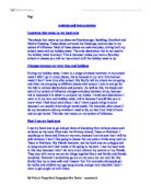
The proposed development will be located in the oldest part of the town, the northwest. Within this area, there are many older buildings, some dating back to the 17th century. The council would look favourably on a new development if some of the local architectural design were incorporated into new builds. A design feature particular to the area, is the construction of the gable-ends of these buildings, the bricks are laid in what is known as 'tumbling bond'. (Fig 1)
Figure 1 example of tumbling course work on the gable-end.
Picture from 'Discovering Cottage Architecture' by Christopher Powell
7:- Preliminary Environmental Impact Assessment
This section provides a preliminary environmental assessment of the affects of the proposed mixed-use development site, identified as WITH 1b on the local development plan. The various environmental elements include:-
* Soil
* Hydrology
* Vegetation
* Habitat
* Traffic and circulation
* Air quality
* Noise pollution
The assessment also considers the visual quality, socio-economics, public services and utilities, and health and safety. The information presented in this chapter is based on a brief site analysis conducted by Mr N. Whiteley on February 9th, 2004.
Aims
Sustainable design assesses both the site and building requirements to determine the site's capacity to support the development without degrading the environment. The preliminary assessment will provide the planning authority with a greater understanding of the proposed development.
General
Preserve natural drainage systems, site buildings, roadways, and parking so that water flowing off the developed site during extreme storm events will not cause environmental damage. Also, consider how drainage systems will be affected during construction.
Hydrology
* Minimize erosion. Locate and design facilities to minimize erosion and impacts on natural hydrological systems.
* Avoid hydrological system contamination. Safeguard the hydrological system from contamination by construction activities and building operation.
Soil
* Minimize excavation and disturbance to groundcover.
* Minimize erosion. Avoid large impervious surface areas and building footprints that collect rain and create concentrated run-off onto site.
Vegetation
* Minimize native vegetation disruption. Avoid cutting mature vegetation and minimize disruption to other natural features.
* Minimize visual impacts. Use natural vegetation and adjust the development plan to diminish the visual impact of facilities and minimize imposition on environmental context.
Habitat
* Law protects bat roosts, badgers and their setts, and nesting birds. If a bat roost or a badger sett is found on the site the council's ecologist or English Nature must be contacted.
Traffic and Circulation
* Construction traffic (50-100 daily trips) would decrease the 'level of service' of roads near the project. All construction traffic would have to traverse the town centre.
Air Quality
* During construction, dust and diesel particulates will be emitted from equipment and vehicles.
Socio-economic
* During construction, there will be a short-term impact on housing in the area.
* The project will need approximately 120 unskilled and skilled workers.
* Local residents will be employed to fill as many as 60 full-time posts.
Noise pollution
* There will be an increase in noise levels near the proposed development.
Hazardous Substances
Several hazardous materials will be used at the development site. The following list summarises typical chemicals currently planned for use at the proposed site:-
* Medium and heavy weight oil, light lubrication oil, generator lube oil, de-greaser.
* Cleaning fluids, detergents and solvents.
7.1:- Mitigating measures
* Consult with landowners and farmers to address field access, re-vegetation, timing, and other sensitive cropping issues.
* Consult with landowners to identify the locations of drainage and irrigation systems.
* Coordinate with farm operators to provide access for farm equipment to fields isolated by construction activities.
* Control dust emissions generated during construction, as necessary, by the control of vehicle speed, by wetting the construction area or by other means; and coordinate with farm operators to provide adequate dust control in areas where specialty crops are susceptible to damage from dust contamination.
* Use water spray as necessary to prevent visible dust emissions.
* Minimize dust emissions during transport of fill material or soil by wetting down or by ensuring adequate freeboard on trucks.
* Promptly clean up spills of transported material on public roads by frequent use of a street sweeper machine.
* Cover loads of hot asphalt to minimise odours.
* Keep all construction machinery engines in good mechanical condition to minimise exhaust emissions.
* The proposed development will include measures to reduce the risk of fire and to contain any spill to prevent contamination.
* A Spill Prevention Control Plan is to be in effect from the beginning of construction and continue throughout the development.
* Diesel fuel is to be stored in areas designed to contain spills such as bunds.
* Hazardous materials are to be stored in structures that meet the requirements of the Work Place Fire regulation.
* Training is to be provided to appropriate workers in materials handling and disposal.
8:- Appendix
8.1:- Health and Safety
A comprehensive occupational health and safety program will be implemented to protect workers during the construction phase of the development. If an accident occurred then there is an accident emergency unit at Withernsea hospital, approximately 1/2 mile from the site. Accidents that are more serious will be dealt with by the Hull Royal Infirmary 20 miles away.
During construction, a health and safety program will be implemented, based on industry standards for accident prevention. Contractors involved with the proposed development will be required by contract to comply with the construction health and safety program.
8.2:- Fire Protection
During construction and operations, facility workers would receive basic fire suppression training to address small fires that could be controlled and/or extinguished with extinguishers. If a fire exceeds the resources available, assistance from Humberside Fire and Rescue Service, (Withernsea Station) would be requested.
8.3:- Further Guidance
* Energy conservation, global warming, and reduction in greenhouse gases (PPG22 on renewable energy, PPG13 on transport and reducing the need for travel).
* Air quality and pollution (PPG23 on planning and pollution control, DETR "Air Quality and Land Use" planning guidance note, issued under cover of DETR Circular 15/97).
* Noise and light pollution (PPG23).
* The need to sustain the character and diversity of the countryside and undeveloped coasts (PPG7 on the countryside, PPG20 on coastal planning).
* Conservation and enhancement of wildlife habitats and species, including the promotion of biodiversity (PPG9 on nature conservation).
* The impact of development on landscape quality (PPG7).
* Policies and proposals for the improvement of the physical and natural environment in urban areas, including maintaining the character and vitality of town centres, making provision for tree planting and open spaces and the general revitalisation of urban areas (PPG6 on town centres and retail developments, PPG3 on housing).
* Policies, which help, conserve the built and archaeological heritage (PPG15 on the historic environment, PPG16 on archaeology).
* Policies for coastal protection, flood defence, and land drainage issues (PPG20 on coastal protection, advice from Environment Agency on flood protection and land drainage issues).
* The need to protect groundwater resources from contamination or over-exploitation (advice available from Environment Agency);
* The environmental effects of waste and mineral extraction, processing and tipping operations (PPG10 on waste disposal and management, and Mineral Planning Guidance Notes (MPG)
* The need to avoid development on unstable land (PPG14), and policies designed to secure the conservation of natural beauty and amenity of the land, including tree and hedgerow protection (PPG7).
8.4:- Site Photographs
View west
View south
View east
Bibliography
EIA Cutting edge for the 21st Century - Alan Gilpin
EIA handbook 2002 - Barbara Carroll
Methods of EIA Peter Morris / Riki Therivel
Guide to Excellence in Development Control - Improvement and Development Agency (IDeA) www.planningofficers.org.uk/page.cp/pageid/32
Discovering Cottage Architecture - Christopher Powell
Local Development plan - www.eastriding.gov.uk
Humber economic development action plan 2003/4 - www.humberforum.co.uk
Humberside structural plan - www.hullcc.gov.uk/jsp/index.php
Sustainable development in regional planning report 7 www.hull.ac.uk/geog/PDF/ykhumb.pdf
Design for residential safety - www.westyorkshire.police.uk/crime_prevention
Planning and building control - www.housingcorp.gov.uk
Building sustainable communities - www.sustainable-development.gov.uk/ areas/subject/sus_comm.htm
Good design - www.odpm_plan_605957
Panning policy statement 6 - www.odpm_source_605981
Environmental impact assessment guide to procedures www.odpm_plan_source_026667
Project management section 3 and 4 www.odpm_plan_source 606200/606201
Mixed use development practice & potential www.odpm_plan_source_606215
Development flowchart - www.odpm_022136
Note on EIA directive for local planning authorities - www.odpm_plan_source_026668
Urban Renaissance - www.cpre.org.uk
www.sustainable-development.gov.uk
ODPM - Planning Policy Guidance 1
www.odpm_plan_source_608222
ODPM - Planning Policy Guidance 3
www.odpm_plan_source_606933
ODPM - Planning Policy Guidance 6
www.odpm_plan_source_6069915
ODPM - Planning Policy Guidance 7
www.odpm_plan_source_6069915
Planning Policy Guidance 9
www.environment-agency.gov.uk/commondata/105385/ppg9.pdf
ODPM- Planning Policy Guidance 10
www.odpm.gov.uk/stellenet/groups/odpmplanning/documents/page/odpm_plan_609570.pdf
ODPM - Planning Policy Guidance 13 www.odpm.gov.uk/stellent/groups/odpm_planning/documents/page/odpm_plan_606930.hcsp
ODPM- Planning Policy Guidance 14
www.odpm.gov.uk/stellenet/groups/odpmplanning/documents/page/odpm_plan_605826.pdf
Planning Policy Guidance 15 www. Planning Policy Guidance 15
www.environment-agency.gov.uk/commondata/105385/ppg15.pdf
Planning Policy Guidance 20 www. Planning Policy Guidance 20
www.environment-agency.gov.uk/commondata/105385/ppg20.pdf
ODPM - - Planning Policy Guidance 22
www.odpm.gov.uk/stellent/groups/odpm_planning/documents/page/odpm_plan_606910.pdf
ODPM- Planning Policy Guidance 23
www.odpm.gov.uk/stellenet/groups/odpmplanning/documents/page/odpm_plan_606911pdf
ODPM- Urban Task Force 'By Design'
www.odpm.gov.uk/stellent/groups/odpm_urbanpolicy/documnets/page/odpm_urbanpolicy_608562-05.hcsp
ODPM-Urban Task Force 'Towards and Urban Renaissance'
www.odpm.gov.uk/stellent/groups/odpm_urbanpolicy/documnets/page/odpm_urbanpolicy_608460.hcsp
References
:- Local development plan - www.eastriding.gov.uk
2:- Local development plan - www.eastriding.gov.uk
3:-Planning Policy Guidance 1 - www.odpm_plan_source_608222
4:-Agenda 21 - www.un.org/esa/sustdev/documents/agenda21/index.htm
5:- www.sustainable-development.gov.uk
6:- Good design - www.odpm_plan_605957
7:- Planning Policy Guidance 1 - www.odpm_plan_source_608222
8:- Good design - www.odpm_plan_605957
N.Whiteley 0300900
N.Whiteley 030090
21