To what extent do beach characteristics change with increasing distance along shore.
Candidate Number:
2514
Centre Number:
8003
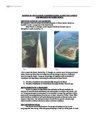
WALTON ON THE NAZE,
ESSEX
Photo1.1
Purpose of investigation
Title: To what extent do beach characteristics change with increasing distance along shore.
Overall fieldwork aim: To investigate changes in beach characteristics with increasing distance along the shore, Walton on the Naze, Essex.
Hypothesis:
. 'As beach height increases sediment size increases'
2. 'As sediment size increases percolation rates increase.'
3. 'There will be significant relationships between percolation rate and beach height.'
In this A Level Geography coursework my coursework is based on the shore of Walton on the Naze. I am aiming to investigate changes in beach characteristics with distance along the shore.
During the investigation of beach characteristics, two sites got investigated by groups of 4 people and total of 4 groups in Walton beach. Each group were carrying same investigation and from straight of 20 metre distance transect beach height, beach percolation, beach sediment of shore got measured by different sets of apparatus.
WALTON ON THE NAZE
Walton on the Naze is situated approximately 80km East of Bishops Stortford. It is a small seaside town, on the Tendring Peninsula, on the Essex Coast by the North Sea about 85 miles North of East London. Part of the town is situated on a headland called the 'Naze'. The Naze is made of soft rocks, which are easily eroded by the sea and since 1963 over 2 hectares of land have been lost to the sea. It is estimated that 2 metres of land are lost very year as a result of erosion. Walton is built on top of low cliffs, the lower half being composed of London clay, red crag above it.
INDEX
. --- Purpose of Investigation --->Pages
2. --- Methodology of data selection, collection and recording ---> Pages
3. --- Data representation --->Pages
4. --- Analysis and explanation --->Pages
5. --- Evaluation and conclusion --->Pages
Section 1: Purpose of Investigation
Background Information
Walton-on-the-Naze is a small retirement town, located near Colchester via the A133 with a population of 40,000. Run by tendering local authority it relies mostly on tourism economically, which is one of the reasons they have a coastal management scheme which has recently been extended to the north to protect the luxurious houses situated there.
Despite of doing some changes along the coast to prevent erosion but coastal erosion, coastal flooding also cliff falls happen on regular basis.
I have decided to study Walton-on-the-Naze for a number of reasons. Firstly it is the nearest place along the coast of Essex which has unprotected cliffs as well as protected ones plus in GCSE I had one day visit to Walton and Clacton which made my mind to choose this topic At Walton the geology is the same and the processes are very similar along with the protection. Also Walton is subjected to much more energy from the sea than Frinton.co
Site Information
Seaside area is 18.6 km above sea level. This area is managed by the Tendring District Council coastal unit, under guidance of the department of the Environmental Food and Rural Affairs (DEFRA). Within this area 17.6 km is protected by highly engineered defence structures. Leaving only 1 km unprotected.
The rest of the area is below 1m above sea and therefore is administrated by the Environment Agency (EA) against flooding-groundbreaking management schemes are being introduced to this area to prevent this.
2514
Centre Number:
8003
WALTON ON THE NAZE,
ESSEX
Photo1.1
Purpose of investigation
Title: To what extent do beach characteristics change with increasing distance along shore.
Overall fieldwork aim: To investigate changes in beach characteristics with increasing distance along the shore, Walton on the Naze, Essex.
Hypothesis:
. 'As beach height increases sediment size increases'
2. 'As sediment size increases percolation rates increase.'
3. 'There will be significant relationships between percolation rate and beach height.'
In this A Level Geography coursework my coursework is based on the shore of Walton on the Naze. I am aiming to investigate changes in beach characteristics with distance along the shore.
During the investigation of beach characteristics, two sites got investigated by groups of 4 people and total of 4 groups in Walton beach. Each group were carrying same investigation and from straight of 20 metre distance transect beach height, beach percolation, beach sediment of shore got measured by different sets of apparatus.
WALTON ON THE NAZE
Walton on the Naze is situated approximately 80km East of Bishops Stortford. It is a small seaside town, on the Tendring Peninsula, on the Essex Coast by the North Sea about 85 miles North of East London. Part of the town is situated on a headland called the 'Naze'. The Naze is made of soft rocks, which are easily eroded by the sea and since 1963 over 2 hectares of land have been lost to the sea. It is estimated that 2 metres of land are lost very year as a result of erosion. Walton is built on top of low cliffs, the lower half being composed of London clay, red crag above it.
INDEX
. --- Purpose of Investigation --->Pages
2. --- Methodology of data selection, collection and recording ---> Pages
3. --- Data representation --->Pages
4. --- Analysis and explanation --->Pages
5. --- Evaluation and conclusion --->Pages
Section 1: Purpose of Investigation
Background Information
Walton-on-the-Naze is a small retirement town, located near Colchester via the A133 with a population of 40,000. Run by tendering local authority it relies mostly on tourism economically, which is one of the reasons they have a coastal management scheme which has recently been extended to the north to protect the luxurious houses situated there.
Despite of doing some changes along the coast to prevent erosion but coastal erosion, coastal flooding also cliff falls happen on regular basis.
I have decided to study Walton-on-the-Naze for a number of reasons. Firstly it is the nearest place along the coast of Essex which has unprotected cliffs as well as protected ones plus in GCSE I had one day visit to Walton and Clacton which made my mind to choose this topic At Walton the geology is the same and the processes are very similar along with the protection. Also Walton is subjected to much more energy from the sea than Frinton.co
Site Information
Seaside area is 18.6 km above sea level. This area is managed by the Tendring District Council coastal unit, under guidance of the department of the Environmental Food and Rural Affairs (DEFRA). Within this area 17.6 km is protected by highly engineered defence structures. Leaving only 1 km unprotected.
The rest of the area is below 1m above sea and therefore is administrated by the Environment Agency (EA) against flooding-groundbreaking management schemes are being introduced to this area to prevent this.