This project tests the theory behind the model of the urban hierarchy.
The urban hierarchy is made up of different types of settlements. Where they stand on the hierarchy depends on a number of factors, the main ones being:
* the size of the settlement in terms of its population
* the range and number of services a settlement has
* the sphere of influence or the size of the area served by the settlement.
The best way to show the urban hierarchy is by using a pyramid, as shown in this diagram.
The most obvious way of deciding where a settlement ranks on the urban hierarchy is by using the population of that settlement. The larger the population, the higher the settlement is placed on the hierarchy.
In the UK, the largest city in terms of population is London, which most people would agree is the most important settlement in the country and so deserves to be placed on the top of the urban hierarchy for the UK.
After that the divisions between what is classified in each layer is a bit more vague. Different sources will have different numbers for how many people are needed for a place to be called a city rather than a town for instance.
The urban hierarchy is made up of different types of settlements. Where they stand on the hierarchy depends on a number of factors, the main ones being:
* the size of the settlement in terms of its population
* the range and number of services a settlement has
* the sphere of influence or the size of the area served by the settlement.
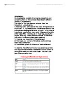
The best way to show the urban hierarchy is by using a pyramid, as shown in this diagram.
The most obvious way of deciding where a settlement ranks on the urban hierarchy is by using the population of that settlement. The larger the population, the higher the settlement is placed on the hierarchy.
In the UK, the largest city in terms of population is London, which most people would agree is the most important settlement in the country and so deserves to be placed on the top of the urban hierarchy for the UK.
After that the divisions between what is classified in each layer is a bit more vague. Different sources will have different numbers for how many people are needed for a place to be called a city rather than a town for instance.