Sasha Zouev
Geography IB, 5/09/05
IB Case Study: Brazil
Population, Distribution, Density
Introduction:
As one of the most commonly studied populous LEDC's in the world, Brazil certainly has very interesting features and patterns regarding its population and distribution. First of all, Brazil is the largest and most inhabited country in South America, and fifth in the world. Its 8,500,000 square kilometer land area borders countries such as Colombia, Venezuela and Bolivia. The aim of this case study is to examine, section by section, the different factors that affect Brazilian population growth and distribution by looking at areas such as geographical positioning, politics, history, and generate some sort of conclusion.
Distribution:
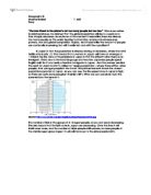
Brazil's population is mostly concentrated alongside the coast. Coastal states, with a sum area of about 35% of Brazil, in fact account for about 87% of the entire population. Brazil can often be divided into clear-cut social, geographical and economic regions (figure 1). Masking half of the country, the Northern area has the dense and tropical basin of the Amazon (largest rain forest and largest river in volume of water in the world). The northeast, which is the most economically handicapped region, relies heavily on agriculture as its main economic activity. The area that is the wealthiest, and contains half of Brazils total population is the South Central region as well as the centres of Sao Paulo and Rio, which happen to be the 3rd and ninth largest cities in the world. The great interior, much of which is still wrapped by the rainforest, remains sparsely settled. Brazil has an overall population density of about 20.5 inhabitants per kilometre square, places such as the Federal District area "Brasilia" (353.5 inh./km2), Rio de Janeiro (328.6 inh./km2) and Sao Paulo (149.2 inh./km2) are the densest areas compared to the bottom sparse places such as the Amazons which only has about 1.5 people per kilometer squared.
Geography IB, 5/09/05
IB Case Study: Brazil
Population, Distribution, Density
Introduction:
As one of the most commonly studied populous LEDC's in the world, Brazil certainly has very interesting features and patterns regarding its population and distribution. First of all, Brazil is the largest and most inhabited country in South America, and fifth in the world. Its 8,500,000 square kilometer land area borders countries such as Colombia, Venezuela and Bolivia. The aim of this case study is to examine, section by section, the different factors that affect Brazilian population growth and distribution by looking at areas such as geographical positioning, politics, history, and generate some sort of conclusion.
Distribution:
Brazil's population is mostly concentrated alongside the coast. Coastal states, with a sum area of about 35% of Brazil, in fact account for about 87% of the entire population. Brazil can often be divided into clear-cut social, geographical and economic regions (figure 1). Masking half of the country, the Northern area has the dense and tropical basin of the Amazon (largest rain forest and largest river in volume of water in the world). The northeast, which is the most economically handicapped region, relies heavily on agriculture as its main economic activity. The area that is the wealthiest, and contains half of Brazils total population is the South Central region as well as the centres of Sao Paulo and Rio, which happen to be the 3rd and ninth largest cities in the world. The great interior, much of which is still wrapped by the rainforest, remains sparsely settled. Brazil has an overall population density of about 20.5 inhabitants per kilometre square, places such as the Federal District area "Brasilia" (353.5 inh./km2), Rio de Janeiro (328.6 inh./km2) and Sao Paulo (149.2 inh./km2) are the densest areas compared to the bottom sparse places such as the Amazons which only has about 1.5 people per kilometer squared.