The Global Positioning System
The Global Positioning System
The low quality training of the US Army showed during the Vietnam War, when it was realised that none of the troops could read a map and work out their position. The US Department of Defence (DoD) decided to try and rectify this problem, using technology and physics, rather than actually teach their troops to read maps.
To begin with, the DoD experimented with 4 satellites, codenamed TRANSIT. These four satellites were in high orbit above the earth. The system was available to both the US military and any marine users. However, the system was flawed, as position fixes could only be made once every 2 hours, in favourable conditions. Obviously, in military applications, this was nowhere near good enough.
In the late eighties, the NavStar system was developed, NavStar standing for Navigational Satellite Timing And Ranging. The system became operational in 1986. However, at this time, NavStar operational capabilities were limited. There were only a small number of satellites in orbit transmitting NavStar data, and so there was only about 3-4 hours coverage every day. Again, this was an obvious limitation in terms of the original specifications of the GPS system. However, the reason for the lack of satellites with NavStar was the explosion of the Space Shuttle Challenger. Challenger was used by the DoD to place NavStar in orbit, and after the disaster, NavStar satellites had no launch mechanism.
However, Saddam Hussein forced the US to upgrade the NavStar system to the GPS system we know today. When the Gulf War began, the US used experimental "Block 2" satellites in the NavStar system, along with the original "Block 1". This gave a usable constellation of 21 satellites. After the war, in late 1990, the DoD made the GPS system available for civilians.
In those days, America understandably didn't want her enemies buying a GPS and having 30 metres accuracy, so a limitation called Selective Availability (SA) was introduced. This rounded the data from the satellite, so that errors of around 100 metres were introduced. How this was actually done will be covered later, briefly, but as of May 2nd, 2000, this is irrelevant. The US turned SA off, saying that the civilian market would benefit from greater accuracy. In the US alone, the GPS industry is worth $300 million, and is a growing industry. The military have been placated by the fact that it is possible to introduce limitations in civilian GPS receivers in specific areas during times of conflict, such as Afghanistan at the moment. This means that all off the shelf GPS receivers can be capable of accuracies of anything up to 3 or 4 metres. Personally, I have had 1 metre accuracy from my receiver, a bottom of the line model. However, atmospheric conditions can affect the GPS signal, either aiding or hindering accuracy. This will be covered later.
In 1995, the GPS system was declared fully operational. All the original specifications set down in DoD and Air Force documents back in the mid seventies were met. Needless to say, many of these specifications are somewhat classified and unavailable to the general public, so I will not go into them. However, from the fact that GPs has been declared fully operational, it is a safe bet to say that the system will no longer be upgraded, only maintained, for a long period of time.
So how does GPS work, and what exactly does it do?
GPS receivers tell the user exactly, with very high accuracy, where he or she is. It can do this in terms of different position giving techniques. For example, in Great Britain, a GPS receiver could give your position as a 10-figure grid reference on the Ordinance Survey national grid, or in terms of old-fashioned latitude or longitude. This means that, even using GPS, the user will still need a map and compass to find his way. It is possible to buy localised maps that can be downloaded into the GPS receiver, and a receiver could then tell you what road you are in, and even what number house. However, maps of this sort can easily cost more than the receiver, and are used mainly for in-car navigation. In other countries, GPS receivers will use the equivalent OS grid for that country. Each GPS can change the way they display the users position, so one GPS receiver will work around the world.
There are several main users of GPS. The first is in the military. Being able to accurately calculate a platoons position on a map is a godsend, especially when the platoon is cold, wet and hungry. While not strictly military users, ramblers and those who enjoy orienteering still do the same sort of activity, so these groups use GPS as well, usually only as a back-up to more traditional map reading skills.
Another large base of GPS users are fishermen and people who regularly work on the ocean. Accurate position fixes are extremely important here, because map reading on the ocean with nothing visible in any direction is impossible. Since SA was turned off, standard GPS units have been able to very accurately give positions. However, when SA was still being enforced, a system called Differential GPS, or DGPS, was used. This will be covered later. Very briefly, it gives a more accurate GPS signal.
Building surveyors also use GPS systems, usually in conjunction with DGPS in order to ...
This is a preview of the whole essay
Another large base of GPS users are fishermen and people who regularly work on the ocean. Accurate position fixes are extremely important here, because map reading on the ocean with nothing visible in any direction is impossible. Since SA was turned off, standard GPS units have been able to very accurately give positions. However, when SA was still being enforced, a system called Differential GPS, or DGPS, was used. This will be covered later. Very briefly, it gives a more accurate GPS signal.
Building surveyors also use GPS systems, usually in conjunction with DGPS in order to get sub 1 metre accuracy. This is can be used in order to settle property disputes between neighbours, and so there can be no complaint about who that 2cm wide strip of grass belongs to. It could also be used in other specialist building surveyor tasks, although it might be better to ask a building surveyor about this. This was an illustration of how a very specialised trade can use something as fundamental as knowing the exact location of something on the planet.
Basic GPS receivers now cost from anywhere around £130 for handheld units, £2 or 3,000 for marine units with DGPS and £40,000+ for very specialised units with 1mm accuracy. With GPS receivers, you really get what you pay for. The more money the unit costs, the better the internal circuitry and timing clock, and the more accurate the unit will be. Even the most basic handheld receivers can not only give the exact position, but can also act as an odometer, recording distance travelled, as an altitude meter, and as an electronic compass. However, in my experience the electronic compass is not to be trusted. The satellites cannot tell which way the receiver is facing, and so the compass isn't the most accurate device ever. Most handheld units can even give information such as daily sunrise and sunset times, to within about a few minutes accuracy.
So how does the whole system work? In the NavStar system, there are 3 components. There are the satellites in space, there are US Air Force control stations, and there are the receivers. The three components, while all are necessary, are not linked together. The control stations simply monitor the GPS signal, whereas the satellites and receiver obviously transmit and receive the signal. In order to deal with transmitting and receiving the signal properly, I am going to detail how the control station works.
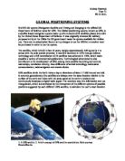
The Master Control facility is operated by the 2nd Space Operation Sqn of the 50th Space Wing, located at Schriever Air Force Base (formerly Falcon AFB) in Colorado (the below diagram is old, and is still labelled Falcon AFB) and there are 4 other control facilities placed around the world.
All of these facilities listen to the signal broadcast by the satellites. When I describe how the satellites are positioned in space, it will be clear that from this distribution of monitor stations, all of the satellites will visible overhead at some point during the day. The data from all monitor stations is relayed back to Schriever AFB, where it is analysed. It is then decided if any corrections need to be made to any satellites. If any corrections are needed, the data is uploaded to the satellite. This new data is saved in the satellites memory, and broadcast to the receivers
If the control stations do not do their jobs properly, and allow a satellite to broadcast a signal that is incorrect, then errors to 100s of metres can be introduced. Therefore, the control segment is very important in maintaining the entire system properly.
It was mentioned before that all the satellites will pass over at least one ground station during a day, and in theory, they should be visible to at least two.
The satellites themselves orbit in 6 planes around the earth. There are 24 satellites in the complete system, meaning that in each plane there are 4 satellites. The planes are inclined at 55o to the equator, and are equally spaced in right ascension, meaning that they are tilting from left to right, looking northwards along a line of longitude. The satellite orbit are not quite circular, but are arranged so that one satellite will exactly orbit the planet twice in one sidereal day. A sidereal day is the time the planet takes to revolve 360o, and is 23 hours, 36 minutes and 4.0954 seconds. The fact that sidereal days do not match 24 hour-long days is the reason why we have leap years every 4 years. From this, we can work out that the radius of orbit is 26,560 km and the orbital speed is 3.899 x 10³ ms-1
While the GPS satellites only orbit at 3.877 x 10³ ms-1, or 1.3 x 10⁻⁵ of c, the speed of light, time dilation (moving clocks run slow, as described in special relativity) occurs, as does time dilation caused by changes in the earths gravitational potential, described in general relativity. General relativity time dilation speeds the clock on the satellite up, whereas special relativity time dilation slows it down. The net effect of this is that the clocks of the satellite run fast, which is corrected by offsetting the clock from the real time prior to launch, and it is maintained by the operating stations. The effects of time dilation on the GPS clocks provide a rare example of both special and general relativity at work.
So far, I have covered the fact that there are satellites floating around in the sky, sending out a signal, which a receiver then translates into a position. However, so far, I have not said how this signal is converted into a signal.
To begin with, we will assume that there is only one satellite and nothing else, and this satellite is broadcasting a time signal. At the moment, it helps to think of the timing signal as saying "my current time is t and my current position is (x,y,z)" If the signal reaches a stationary receiver, it will not be at time t, it will be at time t + ?t. So, for example, if the satellite transmits a signal saying t = 40 seconds, and the receiver detects this signal 80 ms later, when its clock says t = 40.0800 seconds, then logically, the range of the satellite from the receiver is c?t, or the speed of light multiplied by the time taken for the signal to travel the distance. In this case, the receiver is 2.4 x 10⁷ m from the satellite. If we then draw a circle of radius c?t, with the satellite at the centre, then the receiver must be at some point along that circle. (Figure 1)
To obtain a two-dimensional position, then another satellites signal must be used in the same way. The receiver will obviously be on the point where these circles cross. To find where this is, we can use Pythagoras' Theorem, linking (x1,y1) and (x2,y2), the positions of the satellites, their ranges c?t1 and c?t2 with (X,Y), the position of the receiver. From this, we can see that: (Figure 2)
These simultaneous equations can be solved numerically to give a two dimensional position of the receiver. However, only 2 satellites are needed for this.
If it takes two satellites to make a two-dimensional position, then it does not require a leap of genius to realise that three-dimensional navigation requires at least 3 satellites. This is more realistic, because the earth is not flat, and navigating around it as if it was would be unhelpful.
Using three satellites brings us to another set of simultaneous equations, again using Pythagoras. There are no diagrams, as a three dimensional picture would just be confusing.
These equations can again be solved numerically, giving the receivers position (X,Y,Z)
So far, the basic maths being used here has assumed that all the clocks on all the satellites and on the receiver are perfectly synchronised with each other. In reality, this is not true. On the satellites, at least, it is true. All GPS satellites are made with rubidium and caesium, or atomic clocks. We can therefore assume that all the clocks on all the satellites in the whole system are perfectly synchronised, and trust in the USAF master station to negate the effects of relativity in the clocks. However, the clock in the receiver is made from quartz, which is lighter, less expensive and less reliable. The effect of this is that the clock inside the receiver may be running fast or slow.
Say the receivers clock is running ?t fast (known as clock bias error). This means that from each pseudo transit time (the transit time with the clock bias error left in), ?t must be subtracted, as below
However, ?t is unknown, along with X, Y and Z. This is a problem, because there are four equations and only three solutions. To resolve this, another satellite is used in exactly the same way, giving us a fourth equation
As a result of the inconsistency of quartz clocks, a minimum of four satellites are needed. This is not unrealistic, as at any one time there are between 5 and 8 satellites "visible" to any place on earth.
However, the quartz clocks used are still incredibly accurate. To obtain an accuracy of 30 metres, the timing clocks must be accurate to 10-7 seconds (30/108 ms-1)
Every satellite transmits almanac and ephemeris data. The almanac data tells the receiver where to look for other satellites in the sky, given its last known position and the time of day, in order to speed up getting an initial lock on four satellites. The almanac is broadcast from all the satellites in the constellation, all on the same frequency.
The signal available to civilian users is known as coarse acquisition code, or C/A code. This is a binary code, transmitted on the same frequency across the entire constellation. The code is transmitted on a carrier frequency of 1575.42 MHz, which is the frequency drawn from the onboard atomic clock of the satellite. The modulation used is known as phase-shift keying, where the difference between binary 0 and binary 1 is ? radians, or 180o.
The binary code is 1023 bits long, and it repeats itself every millisecond. This means that each bit has a duration of 9.77 x 10⁻⁷ seconds, (10-3/1023) which is 10 times more timing accuracy than is needed for thirty metres. In the receiver, the same binary code is generated that is transmitted from the satellite. However, the clock bias means that the signal produced in the receiver will not be synchronised with the signal produced in the satellite. The signal that is received is time shifted with respect to ?t, and it is this signal that is needed in the above simultaneous equations.
Transmitted Code
0
0
0
0
0
0
0
?t
Receiver Generated Code
0
0
0
0
0
0
0
?t
Received Code
0
0
0
0
0
0
0
To find the value of ?t, the receiver must slew, or "time shift" the receiver generated code along the time axis until there is a perfect match between the two codes. This is known as cross correlating. During this process, the two curves shown above are multiplied together and the area underneath the product is calculated. When the slew time (the distance the signal has to be slewed to be cross correlated) is equal to t then a maximum is established under the curve. Doing this allows transit times to be measured to better than 1/20th of the amount of time it takes to transmit 1 bit of data. This time is 4.88 x 10⁻⁸ seconds, which allows an accuracy of (4.88 x 10-8 x 3 x 108) just under 15 metres.
The satellite code repeats itself every millisecond, which means that the maximum created underneath a correlation peak is not the only peak. There will be other maximums underneath ?t + (integer multiple of 1ms). This creates an inherent uncertainty to ?t, with the effect on the receiver being possibilities of errors in multiples of 300 km. The signal takes 67 ms at least.
The method used to remove this uncertainty is to broadcast additional timing information from the satellite as a telemetry signal. This telemetry is broadcast at a rate of 50 bits s-1, and is superimposed on the C/A code by a process called modulo-2 addition. When a binary 1 in the C/A data is transmitted at the same time as a data bit in the telemetry, the addition will invert the adjacent binary bits, turning 1 to 0 and vice versa. The telemetry code can easily be removed in the receiver.
During trials, the DoD decided that they didn't want civilians having access to GPS with accuracies of 20-30 metres using C/A. As a result, during the 1990's Selective Availability was introduced and used, and this limited accuracy to 100m. SA has now been discontinued, but it may still be of interest to see how the civil GPS can be degraded.
SA can be implemented in two ways. First of all, the satellite clocks were dithered, and made to be less accurate. Since the dithering was different on each satellite, the effect was not the same as changing ?t in the above equations. Secondly, the telemetry data was slightly altered, so that different maximum positions could be used instead of the true maximum position after cross correlation has taken place.
SA could be overcome, however, by the use of Differential GPS, or DGPS. This principle requires an accurately surveyed base station. This base station continuously records its apparent position given by GPS. It then broadcasts the difference between the true position and the apparent GPS position. This difference is transmitted to DGPS beacons, and could provide accuracy of 1-5 metres. However, in the UK, using DGPS required the possession of a license, and an annual fee had to be paid. Limitations of DGPS included the fact that it would only work accurately when the base station was connected to the same 4 satellites as the receiver. Otherwise, the dithering from different satellites would show some inaccuracies, as dithering was different on each satellite.
SA only affected the civil users of GPS, while military users did not suffer from intentional signal degradation. This is because the satellites actually broadcast two different signals. The C/A signal, broadcast at 1575.42MHz is designed for civil use, and it broadcasts on the L1 transmitter of the satellite. The satellite also has an L2 transmitter, broadcasting another signal at 1227.6MHz. This signal is encrypted, and it is designed for military and other authorised users. Differences between the two signals are very small, but they allow for much greater accuracy when using the L2 signal. Instead of using a 1.023MHz bit rate as in the L1 signal, the L2 signal has a 10.23MHz bit rate. L1 has a 1 ms period; L2 has a 7 day period. Information about L2 signal processing is difficult to find, as one can presume that it is encrypted for a reason. It must be very similar to the signal processing that takes place in C/A and L1, but there must be subtle differences.
GPS is not a perfect system. Errors can be introduced into the signal, reducing the accuracy of the receiver. Satellite clock errors caused by Master Control not correcting the clocks can cause errors of the order of several metres. Atmospheric conditions can also affect the signal. The troposphere is the lowest part of the atmosphere, and when temperature, humidity and pressure change, then microwave transmission can be affected. Again, these errors are in the order of several metres.
The ionosphere can introduce errors of 10+ metres. The ionosphere composed of ionised air, which can interfere with microwave transmission in a significant way. Finally, multipath errors can occur. These occur when the signal is reflected around the ground near the receiver, and the receiver picks up both signals. This introduces only small errors, but multipath errors are the only errors that cannot be corrected by some obscure method. The user can make errors, but with the simplicity of GPS receivers on the market now, only technically retarded people could make these errors. And these types of people would not be using GPS anyway - they would brand it witchcraft, and try to burn it at the stake. In this day and age, technology is becoming easier to use, and so nobody should really be making mistakes with a simple, off the shelf GPS receiver. Those using specialist units will obviously have had some sort of training
Bibliography
Physics Education, Volume 34 Number 1 January 1999
The Global Positioning System, AJ Walton and RJ Black
Global Positioning System Overview
Peter H Dana, The Geographer's Craft Project, Department of Geography, The University of Colorado at Boulder, 1994
http://www.colorado.edu/geography/gcraft/notes/gps/gps.html
GPS History
No credited author
http://www.safetrack.com/History.htm
GPS: Theory and Practice, 3rd Edition. 1994
Hoffman-Wellenhof, BH Lichtenegger, J Collins
Advancing Physics A2. 2002
Institute of Physics
Note on sources and bibliography
At times, I found there to be misleading statements within different sources. One major example of this is the way the carrier signal on the L1 channel is carried. Some sources made no differentiation between the L1 and L2 carriers, whereas some others talked at length about only L1 and not L2. As mentioned above, L2 and PPS are military and licensed users only. This means that, while it is still possible to find about the PPS system, it is possible that misinformation may be spread in the public domain. After all, GPS is run by the US Air Force, and it is understandable that they don't want all of their trade secrets known to all. As a result, I have decided to only give L2 and PPS a brief mention.
In other cases, C/A code was also called SPS, or standard positioning system. In cases where sources seem to have confused themselves, I went along with a majority verdict after consulting as many sources as possible. The event of this happening was very rare, but it did happen. However, I am confident that this research is as accurate as it could possibly be.