To condense this, each satellite transmits a message which informs of its identity, current position, and the time at which the message was sent.
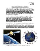
To now determine your position, the GPS receiver compares the time a signal was transmitted by a satellite, with the time that it was received. The time difference then determines how far away the particular satellite is. Through trigonometry, with a minimum of three satellites, the GPS receiver is then able to determine a latitude/longitude position, and with a further satellite, also the altitude. Through constant updates of your position, a receiver can also provide accurate measures of speed and direction of travel.
The accuracy of the GPS system used to be hindered principally by a source of position error called Selection Availability (SA), intentionally imposing inaccuracies of up to 100m on civilian GPS by the US Defense, the idea being that SA would prevent hostile terrorist organisations holding the maximum power of GPS.
Some other factors affect accuracy – the relative positions of each satellite in the sky, multi-pathing (where the satellite reception is blocked/reflected by buildings, obstructions of the like) and propagation delay due to atmospheric effects. Some internal clock errors may also occur.
In order to improve accuracy, one can implement correctional information and computing, as well as using more sophisticated radio reception techniques. A process known as Differential GPS (DGPS) employs a second receiver at a fixed location to compute corrections to the GPS satellite measurements. A number of free and subscription services provide these DGPS corrections, which will considerably improve accuracy. Without the use of DGPS however, accuracy has been measured with a global average error less than 13m.
It was war that was the first to bring GPS to the popular imagination: initially in the Gulf War, and then this year, in Iraq. The US military uses its GPS to deliver bombs, missiles and even individual artillery shells to targes with complete exactitude. This is actually just an extension of the original intention of GPS – to provide guidance and position information to the military.
Now however, the commercial and civilian uses of GPS have outstripped the miliary uses. In 10 years, GPS has proved itself an indispensable tool. It’s predicted that at the end of 2003, as many GPS devices of all kinds will be produced as in the previous 25 years that the satellites have been in orbit, and that in 2004 the number of devices will double again. Indeed, GPS is proving itself a genuinely transformational technology.
Not only is it used by truck drivers, fishermen, hikers and surveyors, but cellular-phone networks are starting their use of the system. Power companies and farmers use GPS, archaeologists use it to return to sites that they have discovered. Two school districts in Pennsylvania with GPS-equipped buses offer families an alert when the school bus is approaching. NASA uses GPS to navigate spacecraft and construction firms use it to navigate bulldozers.
Farming has been one industry to adapt incredibly well to the potential of GPS. Through attaching a GPS receiver to a combine, farmers are able to map which parts of their fields produce best, by recording how much produce was harvested, and linking yields with precise locations on the field. Precise measurements of the fields farmed by GPS have allowed complete accuracy with the application of fertilizer, seed, and nutrients to the soil. Data of activities and distribution of seeds, and the like, can be collected during the day and loaded into computers, providing a realm of accurate information never before available, thus acting as an incredibly useful decision making tool. GPS is even used to steer tractors with more care, completely retracing previous tracks, so that now fertilizer and herbicide applications can overlap less – less is wasted. The next step is tractors that steer themselves, meaning that they would be able to work at night.
GPS is now a doorway, opening up countless possibilities to commercial companies. Delivery companies can now through GPS know their trucks exact location, concrete companies will know where their cement mixers are, as well as when they departed, arrived, started to pour concrete, finished pouring, left the job site, arrived back to the plant etc. Time waste is avoided, production is maximised.
But how can this ‘location awareness’ change the world? How can this ever-growing system impact upon the future? GPS could mean the end of property crime. Anything of value, that has the potential to be stolen, could be relocated through GPS – everything will know its location, and be able to report it.
Insurance companies would be able to sell auto insurance based on how you actually use your car. They then review the GPS information on where you’ve driven, how far, how fast, and can bill you for the risks that you’re taking. A trial has already been performed in Texas using such a system.
Indeed, commercial companies are now using GPS for ultimate knowledge – knowing exactly where their units are, and what they are doing, in the mould somewhat, of Big Brother. Big Brother-esque again, is the fitting of GPS chips into mobile phones. By the end of 2005, all mobile phones sold in the US must be able to report their location. The GPS phone will know where it is and be able to report that information, if it is stolen, in an emergency, if you are lost.
Further GPS research can only further the dominance of this technology, providing a future with greater awareness, greater knowledge, openness and even wider communication, making the world once more a smaller place.