Gradometer
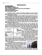
Defences at Sutton on Sea and Huttoft.
Sea wall.
The idea of a sea wall is to put a physical barrier that the waves cannot pass between the sea and the land behind the beach. They are made of heavy concrete and are very expensive. They can be curved on the seaward side so that they throw the waves back destroying there energy. Sea walls can be susceptible to erosion so can be expensive to maintain. This is a hard defence.
Sea wall mostly buried by sand at Sutton on Sea.
Rock armour
These are simply large boulders placed along the beach. So that when there is a raisd sea level and or wave height the waves travel up the beach and hit the boulders which helps to destroy the wave energy so that the waves cannot travel much further up the beach. This is a hard defence.
Rock armour although partially buried by sand.
Ceebees.
These are deep hexagonal blocks which have a whole down the inside. They are placed at approximately a 45degree slope so that a wave breaking upon them will enter the holes and the water will swirl around destroying the wave energy. Because of there hexagonal shape they tessellate so many can be placed together along a slope.
The 1953 Floods
The floods happened at 5:25pm on the 31st of January 1953 after a bad storm surge. There was no flood warning and the sea defences that were currently in place were not good enough to hold back the sea. The floods caused terrible damage with 307 people killed 24,000 houses damaged or destroyed, 150,000 acres of farmland destroyed, which were rendered un-useable for several years afterwards as well as the loss of a lot of livestock. 30,000 people were evacuated and over 200 industrial buildings were destroyed. The overall damage of the floods was estimated at the time to be around £50million.
Devastation of the 1953 floods
Areas Flooded in 1953 Floods.
Beach Nourishment
After the 1953 Lincolnshire realised how tragic a flood could be particularly as Lincolnshire is a very low are of England and is at greater risk from flooding. With the tourism, housing, population and work in coastal areas of Lincolnshire a flood is devastating to the local communities. So in the 1990’s a large scale beach nourishment project was put into place where 20 million tonnes of sand and other material was dredged from 20km off-shore and pumped onto the beaches giving an extra 7.5 million cubic meters of sand. This ment that the beaches were more sloping and the waves would have to travel further and at a steeper angle up the beach destroying a lot of the wave energy. The estimated cost of the entire project was £50 million and took 4 years. There was now more protection for the local communities and there was more beach so tourism increased slightly. One problem Is that before the extra sand was put in place the sea would cleanse the sand when the tide was in or heavy rain, but now that the beaches are longer and steeper the top areas of the beaches are not cleansed, so this has to be done by specialist machinery.
The Layout of Huttoft and Sutton on Sea.
Huttoft
Here you can see that the waves must travel up the beach and then they hit the ceebees and rock armour which will destroy a lot of the wave energy. If the waves get above these then there is an angled carpark and bank which will destroy wave energy as it spreads across them
Sutton on Sea
At Sutton on Sea there is a sea wall at the edge of the beach and straight on the other side is the town and houses. The sea wall is a good sea defence and should stop most waves unless there has been a bad storm surge.
Other sea defences include;
Groynes: These are long wooden barriers placed down the beach perpendicular to the sea. They slow down longshore drift so that there is more sand on the beach. Longshore drift is where waves push large quantities of sand along the beach which can therefore make certain areas where there is a low amount of sand more susceptible to flooding.
Gabions: These are netted wire boxes which contain medium sized hard rocks inside.
Revetments: revetments are slatted and angled low wooden walls parallel to the beach. They act to absorb wave energy and protect soft cliffs. The waves break upon it and water can pass through but they destroy most of the energy. These can be susceptible to rapid erosion.
Dragons teeth
Concrete blocks held together form a powerful sea defence, these are known as dragon’s teeth