Other reason why some places are more a risk than others is because of their prediction and evacuation systems. In poorer countries such as Indonesia they don’t have the equipment or expertise to predict earthquakes and they don’t have the media to broadcast potential volcanoes and this leaves these places more at risk than places such as Iceland which have better prediction, planning and preparation and this leaves them less chance of experiencing a major volcanic disasters.
Another reason why some places are more prone to major disasters is the density of population in the danger areas around volcanoes. An example of this is Mount Vesuvius with a population of 3 million in a very dense area. The higher population density makes major volcanic disaster more likely because it is harder for people to all evacuate safely before an eruption and this makes a disaster more likely.
To conclude some places are more prone to major volcanic disasters for a number of reasons from physical aspects like their geographical position to human aspects such as population density around volcanoes and prediction and planning procedure.
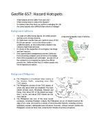
(b) Explain why the Philippines and California multiple hazard spots are affected by disasters in different ways?
The Philippines is a cluster of many islands and they suffer from many hazards within the area. The Philippines situated upon an active destructive plate boundary and this means that they have many highly active and highly explosive volcanoes on these islands (17). As it is on a destructive plate boundary there are also a high number of destructive earthquakes (65 in 400 years) because of the high pressure within the subduction zone. The Philippines also experiences many tropical storms due to its latitude and on average experiences from 4-12 per year with an average death toll of 529 people and an average cost of 90 million US dollars. Also most of the population live on the coast and due to poor land management they have removed most the mangrove which protect the land from tsunamis and this leads to a high potential for hazards. There is also an ever increasing threat from hydro-meteorological hazards and mudflows and landslides are very frequent and often highly devastating. Also events such as el Niña can cause high amounts of flash flooding within the Philippines.
California is situated on the West coast of America and lies on top of a conservative plate boundary (the San Andreas Fault) with the pacific plate moving faster than the North American plate both in a north-easterly direction. This can cause numerous and devastating earthquakes in California an example being in 1989 in san Francisco, which was 6.9 on the Richter scale and caused 62 deaths and caused many buildings and roads to collapse like the Nimitz highway. Also in California there are frequent wild fires because of the high temperatures (especially in El Niña years). Another hazard is photochemical smog with is a man-made hazard, as the dry air descends from the sierra Nevada mountains it traps the emissions in a pollution plume and this can lead to serious health problems such as asthma and respiratory problems in the future.
The two areas are vastly different with the Philippines being a R.I.C (rapidly industrializing country) with a low income and where poverty is a major factor and this can be hugely detrimental to the country as it tries to cope with disasters and it also increases the vulnerability of the people living there. Compare this to California which is a very rich region with a population just over 37 million and because of this it can cope very well as it can implement the 3p’s: Preparation, Planning and protection. This means that despite its high vulnerability to disasters it can cope very well with them with little loss of life, but still high economy losses. This is different to the situation in the Philippines as because of its poverty it struggles to plan and prepare for hazards and is ill equipped to cope with high fatalities and huge economy losses for its people in proportion to their actual wealth.