3. Education : All schools and workplaces need to make sure that they students or employees have undergone an earthquake training so they know how to protect themselves during an earthquake. Here things like “Duck, Cover, Hold” are taught so people remember what to do.
4. Extensive research takes place in California, in this subject where they find new ways in order to predict earthquakes more accurately.
5. Emergency procedures have been also put in place. For example Action plan on what will happen in certain scenarios. Also emergency authorities like hospitals have been informed of routes to take during such an event, this means that more people are saved if this event took place. Thus, perceived risk in California is very low due to such measure put in place.
California has been very successful till now in managing the risk of earthquakes. In the Loma Pieta earthquake on 60 people died in this huge state, and this was due to the collapse of the Nimitz Highway. This shows us how the system put in place has helped reduce the vulnerability of the area.
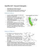
Hazard 1 Earthquake: Philippines
The Philippines has been an earthquake hotspot for years this is because:
- The Philippine plate and the Eurasian plate can become locked together as one moves under the other. This causes pressure to build up. When the pressure is too much the plates jerk past each other, causing an earthquake
-
Earthquakes also occur at fault lines in the area, where the plate has cracked under pressure
- Unlike California, where earthquake rarely occur and usually occur on a much larger scale, in Philippines earthquakes are a daily event, but most can't be felt (they're low on the Richter Scale)
- An earthquake of magnitude 7.8 occurred on Luzon Island in 1990, killing over 1500 people.
Although the Philippines suffers from more hazards than any other country in the world, a lot has been done to reduce the vulnerability of many of the hazards that occur. However, being an LEDC’s, Philippines suffers from lack of capital as a result employs cheaper management strategies than compared to California who spend a lot of money on research for prediction of earthquakes.
For example, when the Bohol earthquake struck the Philippines, rescue personal were immediately deployed in order to search and rescue the people who were trapped under buildings. Although the final death toll was estimated to be 195 people dead and 650 people injured, this shows that the mission was successful. However, it does highlight Philippines weakness in terms of organization. Unlike, California, the Philippines had not planned for emergency services before hand as a result this led to increased death compared to the Loma Prieta earthquake which was one of a larger magnitude but only killed 65 people during 1970 when technology was not as developed as now.
Another low cost management technique practiced in enforcement in education. The education board has made it mandatory for students and employees in the workforce to be aware of what is to be done during an earthquake. Although this is a simple and a low cost approach towards management it has been beneficial. This approach is also followed in California and has proved to be very successful.
Furthermore, under the “Hyogo Framework for Action”, this has been discussed that every disaster should have a disaster management plan. So people know hat exactly should be done during an earthquake. This includes making an action plan with emergency services. It also tries to highlight the probability of the disaster. Under this protocol a “Disaster Action team” has also been arranged for these are people who are trained and exactly know how to rescue people during an earthquake. However the reality is that due to the number of disasters that occurs in this place it is heavily dependent on NGO’s and aid from foreign countries like China, this however is unlike the case in California, who can support themselves during an hazard.
Hazard 2: Volcanoes: California
California also suffers from volcanoes, although these are not as frequent as earthquakes. The last volcano occurs in 1915. The volcanoes occur here due the San Andreas fault. So the magma rises up due to intense heat and pressure from the surface. Some of the volcanoes here are Mount Shasta, Lassen Peak and Medicine Lake Volcano.
Management: A lot has been done in California although there is currently no reported active volcano in this state.
1. Firstly education has been given to communities especially those living near a volcanic area, in terms of the protection they can take to save themselves, including warning systems put in place locally.
2. Insurance has to be taken by all so many will not be affected by an event like a volcano or an earthquake.
3. The California Volcano Observatory has been put in place to continuously monitor the volcanoes and report any unusual findings. This is done by the use of sensors that are put in place on the crater of the volcano. Furthermore, GPS data is used to gather more information.
4. Research has been also put in place in order to be able to predict volcanoes in even greater precision.
5. Lastly, a Hazard assessment sheet has been produces which show if an volcano was to erupt, how the flow of lava will be, techniques that can be used like lava solidification or diversion. The probability of eruption and the risks associated are also important parts of this document.
Since there was no recent eruption it is hard to judge the success of this new scheme.
Hazard 2: Volcanoes: Philippines
Taal has erupted thirty-three times since its earliest recorded explosion in 1572. The 1911 eruption resulted in 1,334 deaths and covered an area of 2,000 sq km with ash and volcanic debris which fell as far away as Manila. The island is small and the population is less than 4,000 people. However, they are relatively prosperous. The economy is based on fishing, fishfarming, agriculture, mining for scoria (volcanic deposits), and tourism. The location of settlements on the island is closely related to the rich fertile soils that are suitable for sweet potatoes and corn. Alarmingly, population growth is rapid - 9.6 per cent per year - more than three times the national average. Moreover, the island could not cope with a major eruption. It contains only 215 boats which could transport less than 2,000 people. Hence, in the event of a very sudden eruption with limited warning, only about half the population would be able to escape. A disaster Management Training Workshop in 1988 found that there was very little anxiety on the part of the population over the risks they faced. This was true even among survivors of the 1965 Taal eruption. The lack of escape boats was also of minimal concern. Islanders referred to a building set up by the Philippine Institute of Volcanology (PIV), as a form of ‘volcanic eruption insurance policy’. They assumed that the PIV would look after them in the event of a disaster. The very presence of a warning station made some feel that the island was therefore safe for them to live on. Thus the local resident population took a view in which Taal volcano was just one of many perceived risks that influenced their decision on where to live and work. By contrast, members of the Disaster Management Training Workshop sought to prevent residential occupation of the island. They adopted a narrow view of risk and vulnerability based on physical processes, and failed to acknowledge the advantages that the area offered. Each side has an entirely legitimate and logical response to the same hazard. However, their views differ because of their different needs, priorities, perceptions, and values
Management:
The rise of magma beneath a volcano may fill a magma chamber and distort the shape of a volcano. Seismometers monitoring earthquakes often pick up large clusters of earthquakes before and immediately after a volcanic eruption. Gases may seep from fissures in the surface known as vents or fumaroles. The temperature of Lake Taal, for example, rose from 33o C in June 1965 to 45o C by the end of July 1965. The water level also rose during this period. In September 1965 the volcano erupted violently.
It is impossible to prevent volcanoes from erupting. In addition, it is virtually impossible to monitor all active volcanoes. However, there are a number of measures that can be taken to limit the damage from volcanoes. Satellites offer the prospect of global coverage from space. Hazard zonation maps can be used to guide decisions regarding evacuation and other responses. Land-use planning is also important. Monitoring of active volcanoes provides early warning of likely eruptions. The most reliable forecasts depend on detailed monitoring of micro earthquake activity in the vicinity of the volcanic cone, which indicates that magma is working its way upwards. Other measures, including preparation of contingency plans can be used to reduce the effects when vulnerable areas cannot be avoided.
As volcanoes are not a frequent feature in the Californian coast, we can argue that the management of volcanoes is more developed in Philippines than in California. In fact, Philippines spends a lot of money on the management of this hazard as it is the one hazard that affects Philippines the most.
Hazard 3: Tsunami: California
Some areas of California are more vulnerable than others for this Hazard. The Long Beach area is a flood hazard zone due to the coastal subsidence linked with oil extraction. The area now is 9 meters lower than it was 40 years ago. While a seawall was built it was not very effective.
Tsunami occurs in California because of the Pacific Coastline near Los Angeles which is proned to tidal waves, triggered by submarine earthquakes or volcanic activity. For example when the Tohuku earthquake took place in Japan, a tsunami (although very small) was generated. Flash floods are also very common in inter when intense rainstorms saturate the ground and wash over bare surfaces.
Management:
Observation centers are put in place to continuously monitor the sea level. For example the Hawaiian Observatory reported than an tsunami could be generated in the Pacific coastline, this led to the people being warned before time leading to only 1 death. Sensors are also put in the ocean to monitor the water level and report any changes.
Education is also provided on government websites in terms of what can be done during the event and before the event (if known).
News stations also make announcements when an event is about to break, to make people aware of the situation, so they can take precautions.
Has it been successful?
I would say yes. This is because tsunamis have almost always been detected before time in California and there have been a very small amounts of deaths due to this hazard. Therefore, he risk is low.
Hazard 4: Landslides and Mudflows: California
The problem is California’s climate, in which most of the rainfall is concentrated into a winter season which typically lasts from November through April. Those sudden torrents of water further destabilize the loose material on the slopes, causing it eventually to give way. The most common type of landslide is a mudslide of the sort that hit Camarillo Springs, in which water-saturated soil and rock fragments form a muddy slurry and then slide downward at speeds of up to 35 miles per hour, taking with them bigger rocks, vegetation and both natural and man-made debris.
Meteorologists say that it takes about 10 inches of rain in a season to loosen the hillsides enough to create the risk of landslides. Once that benchmark has been hit, a brief but intense rainfall — say, 2 inches in 6 hours at lower elevations, or 4 inches over the same period in the mountains -- can trigger a sudden debris flow. The vulnerability is accentuated in places where summer fires have denuded slopes of trees and other vegetation.
Management: A lot has been done in California in order to reduce the impact of Landslides.
1.Hazard Mapping: This is done to show areas that are vulnerable to landslides, government regulation doesn’t allow building in such areas identified as “potential landslides”
2. Cliff regarding: Some areas of California which are made of weak material like clay have been regarded to give more stability.
This diagram shows how cliff stabilization is practiced in California.
3. Land use planning is also a very important part of managing land slide. The government tries to make sure that nothing is built on materials like clay which are vulnerable to landslides as well as liquefaction.
Hazard 4: Landslides and Mudflows: Philippines
-
The Philippines gets a lot of rain. If a lot of rain falls in a short space of time in areas with steep slopes, landslides can occur
- Landslides can also be triggered by earthquakes
- A landslide occurred on Leyte Island in 2006 after it had been raining heavily for 10 days. A whole village was buried (including a school), killing hundreds.\Hazard 4: Landslides and Mudflows: California
Management:
Early warning system for landslide:
The mapping of areas subject to moderate and high susceptibility to landslides is a tool for increasing the awareness of the existing conditions that expose people to landslide. Rainfall advisories are also critical information that people need to understand better and use for early warning.
Assessment of evacuation centers:
Evacuation centers such as schools, churches, and covered courts that communities identified are assessed in relation to carrying capacity and structural safety particularly during strong typhoons and earthquakes. The assessment includes evacuation routes such as bridges and streets.
Mapping of houses and families in areas of moderate to high flood and landslide susceptibility
To determine the number of people (especially women, children, elderly, people with disabilities, pregnant women) living in areas prone to landslide and flood that need to be evacuated, community leaders are conducting house mapping. This will form the basis for distributing families to evacuation centers during intense and continuous rainfall and to monitor their safety.
Overall, I think for this hazard California has done much more. This is due to the funds they have access to. In fact, California is researching on new ways in order to reduce the risk of landslides.
Conclusion:
Overall, I would say some hazards are harder to manage than others. For example, it is much easier to predict an earthquake than a volcano. This is mainly the case as earthquakes do not show any signs like volcanoes show signs of volcanic gases (S04), however a plate slip occurs in few seconds as a result there is less time to prepare for an earthquake than a volcano. Similarly, it is very difficult to predict a landslide, as these are very sudden movements in land along a slip plane. Although what we could do is land use planning by not building in vulnerable areas. Thus, different hazards pose different risks to the state of California. To conclude, due to the funds California has access to to it is reasonable to expect them to have better management strategies compare dot the Philippines.