Discharge is the volume of water that flows through a section of the river at a given time. It is calculated by multiplying the average velocity (ms-1) of the river by its cross-sectional area (m2), giving the discharge as cubic metres per second – cumecs (m3s-1). Downstream at Site 2, I predict that the cross-sectional area will be larger than that at Site 1 because the river will have had enough energy and bedload to erode wider sides and a deeper, smoother bed without large boulders obstructing the flow. The increased area and velocity should together result in an obvious gain in discharge. Although the lack of intercepting vegetation and peaty soil type at Site 1 are typical factors in the increase of discharge, I do not believe that they will be significant enough to make an important difference to my prediction.
Bedload Size: I predict that the size of the river’s bedload will be greater at Site 1 than at Site 2.
This final hypothesis is based on the prediction that a river in its upper course has less energy than at later stages of its journey, so it is less able transport and erode the material in its bedload. The average size of bedload will decrease down river because as discharge, velocity and turbulence increases, more energy is available to break-up material and carry the fragmented pieces in suspension or transport them by saltation and traction.
Methods of Data Collection
Cross-Sections
It was necessary for me to produce a cross-sectional area of the river at both sites in order to calculate the changes in its discharge. From the data gathered I’m able to produce a scale diagram of the cross-section.
The first stage of the process was to measure the bankfull width of the river with a long, waterproof tapemeasure that was stretched taught from one bank to the other, perpendicular to the course of the river. The start and finishing points of the measuring were points where the vegetation and gradient of the bank suggested that he river had reached its maximum capacity. If the water were to rise above this level, flooding of the surrounding area would occur. The ends of the measuring section were determined by observation from directly above the tape at 90° to the ground. Observation from this angle ensured that the margin of error was kept to a minimum.
Having established the width of the river, the next stage was to find its depth at regular intervals across its width. The number of readings taken varied between sites and a compromise was found between excessive work and loss of detail by taking measurements at intervals of 10% of the total width (i.e. 2m width = 20cm intervals). The tapemeasure was used as a guide to ensure that the measurements were taken in a straight line and it was also a convenient way to measure the intervals between readings.
A rigid surveying pole was immersed in the water at each interval until it just touched the bed of the river. A reading was then taken with the aid of a standard 30cm ruler of the depth of the water, the results were then carefully recorded.
Velocity
The technique used to calculate velocity in the river varied between the two sites. At Site 1 the depth was insufficient to take recordings at varying depths. Instead, to find the average velocity for the site, ten measurements were taken with a flow vane in areas of varying speeds of river flow.
At the second site it was possible to take a wider range of recordings due to the increased depth of the river. Using the same intervals that were used for measuring the cross-sectional area, recordings were taken at 10cm, 20cm and 30cm depths across the river. From the results it will be possible to illustrate lines of equal velocity – isovels – and to determine the position of the fastest current.
The flow vane used recorded the revolutions of its screw as clicks. The data collected on the fieldwork exercise was recorded in the form of clicks per minute, but when manipulating and analysing the data it is necessary to transform the number of clicks into metres per second using a simple formula.
To reduce turbulence, the observer carrying out the velocity exercise always stood downstream of the flow vane, otherwise the water would have been disturbed before it flowed over the screw. Also, the vane was always held vertically with the screw pointing upstream to increase the accuracy of the results.
Bedload
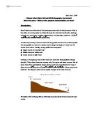
To investigate my third hypothesis, measurements of the bedload had to be taken at both sites. This was done by taking a stratified sample of 50 pieces of bedload and grouping them into five classes from smallest through to largest (smallest being grains of coarse sand and largest being rocks and small boulders between 0.2m and 1m long). Measurements were then taken using callipers of the long axis and the short axis of each item of bedload. Another recording was made of the angularity of the selected bedload. This was done by making a subjective observation using the Power’s Angularity Chart (see right) which uses a set of six pictures to aid judgement in identification.
Analysis
Site 1 Site 2
Cross-sectional Area 0.278m² 2.22m²
Wetted Perimeter 2.12m 9.4m
From the above data, presented in the channel cross-sections (Figures 4 and 5), it is possible to calculate the hydraulic radii at the two sites on the River Bovey. The hydraulic radius is the ratio between the area of the cross-section of the river channel and the length of its wetted perimeter:
Site 1: Hydraulic radius = 0.278/2.12 = 0.131m
Site 2: Hydraulic radius = 2.22/9.4 = 0.236m
The river channel at Site 2 has a larger hydraulic radius, meaning that it has a smaller amount of water in its cross-section in contact with the wetted perimeter. This creates less friction which in turn reduces energy loss and therefore allows for greater velocity. This indicates that the river at Site 2 is more efficient than Site 1.
The river at Site 1 has a smaller hydraulic radius meaning that a larger amount of water is in contact with the channel bed and bank sides. This results in greater friction, more energy loss and reduced velocity. Therefore Site 1 is less efficient than Site 2.
The shape of the cross-section controls the area of maximum velocity in a river channel and the point of maximum velocity at each site varied. The cross-section of Site 1 (Figure 4) shows a slight asymmetrical channel, which is a characteristic of a meandering river in its youthful stage (meandering evident in field sketch (Figure 3)), and the area of maximum velocity was on the right side of the cross-section. The cross-section at Site 2 (Figure 5) shows a more symmetrical channel and the maximum velocity (Figure 6) is nearer the centre of the river where friction is least away from the surface, banks and bed.
Both cross-sections (Figures 4 and 5) also show that the river channel at the two sites is roughly at half the depth of its bank-full level. This is due to river levels being at their lowest in summer, which is when the fieldwork was undertaken, when Dartmoor, and the rest of Britain, receives less rainfall and when evapotranspiration rates are at their highest.
Discharge is the amount of water originating as precipitation which reaches the channel by surface run-off, through-flow and base-flow. It is calculated by multiplying the average velocity (ms-1) by the cross-sectional area (m²)
The formula is usually expressed as: Q = A x V
Where: Q = Discharge (volume measured in cubic metres per second or cumecs (m3s-1))
A = Cross-sectional Area (Figures 4 and 5)
V = Average Velocity (Figures 6)
Site 1: Q = 0.278 x 0.189 = 0.52542 m3s-1
Site 2: Q = 2.22 x 0.46 = 1.0212 m3s-1
The area surrounding Site 2 has heavier vegetation cover than Site1, which usually helps to prevent increased discharge by interception and storing moisture on leaves, but it mainly consists of deciduous trees that shed their leaves in winter and therefore decrease the level of interception.
The main reason though for the difference in discharge is that Site 2 has a much larger cross-sectional area and a larger velocity due to its greater efficiency.
Analysis
The Bed Load Data table (Figure 7) indicates a clear distinction between the samples of bedload taken at the two sites. On the fieldwork exercise it was possible to identify the proportions of different sizes of load on the riverbed.
At Site 1 approximately half of the bedload consisted of ‘large’ stones and rocks (with a long axis greater than 14cm) and the smallest proportion was that of ‘small’ particles that were estimated to be 0.25cm in length and width. At Site 2 though, approximately half of the bedload consisted of particles classed as ’smallest’ (around 0.2cm in length and width) but less than 10% of the bedload was of the ‘large’ variety.
The average length of the long axis at Site 1 was 13.5cm, whereas at Site 2 it was only 4.8cm. This decrease in bedload length between sites is also the same for the short axis; average length of the short axis at Site 1 was 5.9cm, whereas at Site 2 it was 3cm
The angularity of the samples of bedload did not however differ greatly between the two sites. Site 1 had an average power index of 3.05 and Site 2 had a power index of 3.52. But the most frequent, mode, power index at Site 1 was that of 4 (sub-rounded material), whereas at Site 2 it was 3 (sub-angular material).
Conclusions
The analysis of results indicates that the hypotheses made (based on knowledge about the ‘theoretical’ river) before the fieldwork exercise were correct:
- The average velocity of the River Bovey at Site 2 was greater than at Site 1.
- The discharge of the River Bovey was greater at Site 2 than at Site 1.
- The bedload size was greater at Site 1 than at Site 2.
The average velocity increased downstream because the river at Site 2 had a deeper and broader channel than at Site 1. Although Site 1 had a slightly steeper gradient, the channel was shallower, narrower and was filled with larger, more angular material. These factors, along with the channel at Site 1 having a more asymmetrical shape and a larger hydraulic radius, lead to an increase in friction and therefore a reduction in the overall velocity. As there was less resistance from the more efficient and symmetrical shape of the channel at Site 2, the river had a faster flow due to the lack of friction. Also, there was a gain in velocity due to the depth, width and discharge of the river being increased at Site 2.
The discharge also increased downstream because the two factors that affect the discharge both increased; the velocity (as explained above) and the cross-sectional area of the channel. The cross-sectional area was larger at Site 2 because the river had more energy and a larger quantity of bedload to widen the sides and deepen the riverbed mainly through the process of corrasion – the major method by which the river erodes both vertically and horizontally. It occurs when the river picks up material and rubs it along its bed and banks, wearing them away through abrasion, similar to the way sandpaper works.
The size of bedload decreased downstream because the river at Site 1 had less energy and velocity than at Site 2, therefore it was less able to transport and erode the material in its load. The average size of bedload was smaller at Site 2 because as it got transported downstream, boulders and rocks collided with each other and other material leading to impacts that may have resulted in the rock being broken up into smaller pieces – an erosive action known as attrition. Also, in time, this process leads to angular rocks becoming increasingly rounded in appearance. Although, the results from the fieldwork show that there was little difference in rock angularity between the two sites.
Conclusions
Effectiveness of the Fieldwork
Although the data collected was sufficiently adequate to draw sound conclusions that were plausibly explained, the methods used had many limitations and left room for errors in measurement.
I believe the means by which the channel cross-sections were recorded was extensive enough for the level of accuracy that was required. Errors in observation would not have made a noticeable difference to the results as the shape, cross-sectional area, width and depth of the channels varied greatly between the two sites.
When collecting data for the velocities at the two sites, it became apparent that there was a significant margin for error when using the required instruments. The results gathered were however sufficient enough to identify a noticeable difference in average velocity between the two sites. A more systematic sampling method for taking readings at Site 1 would have been useful in calculating a more reliable average velocity and thus a more accurate calculation of the rivers discharge at that site. The measurements of velocity at Site 2 were again sufficient to identify areas of increased velocity and also adequate to work out the average overall velocity, but they were not comprehensive enough to construct accurate isovels on the velocity diagrams (Figure 6).
The most ambiguous results collected were those of the bedload, despite the use of a sampling technique with appropriate classes of strata selected. A stratified sampling method was employed to identify the proportions of bedload size, but it was based on our own personal observations that may have been inaccurate or semi-unintentionally biased towards establishing the hypothesis as correct. A stratified random sampling technique could have been used to make the data collection as fair as possible, which would have meant the avoidance of any bias or misleading results. However, it may have involved considerable time, energy and difficulty in selecting and visiting each area of the riverbed required.
In order to have identified an even greater variation in velocity, discharge and bedload size between points on the river, I believe a site that was further downstream than Site 2 could have been studied. This would have established a more comprehensive understanding of how a river’s form, velocity and load change during its course. Also, if other sites very close to the ones studied had been selected, it would have been quite likely that the results would have differed to a noticeable extent. The same is true if the study had been undertaken during a different, wetter period of the year.
Overall, the fieldwork exercise was extensive and comprehensive enough for the desired level of accuracy required to produce a clear and adequate understanding of the theories and concepts involved. The River Bovey appears to behave how a typical river should – adopting channel form, shape and levels of discharge that best fulfil its two main functions: transporting water and sediment to the sea.