Location 2
Western Exposure, Middle Hope (ST 3245 6605)
Conclusion
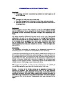
The similarities between both log sections are that both contain tuff. Tuff is consolidated ash from a volcano, which tells me that both beds were near the same volcano. One difference is, location two has more beds of tuff than on location one, which suggests that location two was nearer the volcano. The grain size also backs up this theory. Location two contains more variety of grain sizes, from fine to larger. The larger particles are heavier therefore cannot travel as far with waves or wind. Finer grains are deposited further away as they are lighter and more easily carried (by suspension and solution). Another similarity is both sets of beds contain calcite veins running within them that are precipitated directly from seawater. This suggests both beds could have been submerged in water.
Both sets of beds contain lamination showing at one point or several points in the making of these beds that there could have been some kind of flash floods in the area or possibly they were on the same tidal flat.
Differences include: Location one identifies cross bedding and graded bedding in bed 5 and symmetrical ripples in bed 7. This shows me that there could have been a two directional current as that is what is need to form both symmetrical ripples and cross bedding. However, Location two only shows asymmetrical bedding and unidirectional current is needed for that to be produced. Another difference is Location two has pillow lavas in bed 18. This gives more evidence to show that it is nearer to the volcano. Also in bed 19 there is evidence of a slickenside, which could only be produced if a shelf was present.
In Location two there was more bioturbation in the beds, for example bed 6 and bed 12 than in Location one where it was only located in bed 7. This could have because the environment in Location two could have been more susceptible for burrowing to happen. In general Location two shows more evidence of fossils within the beds, this could imply that it was nearer to a reef or a at the base of a slope where organisms fell from. The reef also could have started growing and then get submerged in ash from the nearby volcano and then re-grow, creating more beds with fossils included within them. Location two in beds 2, 3 and 12, also show more weathering. This could suggest that the rock here was softer than rocks in beds in Location 1 where is seems that harder rocks dominate.
This is a diagram of how I would have expected the locations to be positioned.
The type of explosion that could have protruded from the volcano could have been a Phreatic Eruption. "Phreatic" (or steam-blast) eruptions are driven by explosive expanding steam resulting from cold ground or surface water coming into contact with hot rock or magma. The distinguishing feature of phreatic explosions is that they only blast out fragments of preexisting solid rock from the volcanic conduit; no new magma is erupted. Phreatic activity is generally weak which could explain evidence of a none violent volcano. However, they can be quite violent in some cases, such as the 1965 eruption of Taal Volcano, Philippines, or Mount St. Helen’s April 10th 1980.
Evaluation
The good aspects of the fieldwork were that we collected primary data ourselves making it individual. This also makes sure that it was all collected the same way. The negative aspects were we could have got more detail on some of the rock description, as it would have been easier to produce a more exact log.
The things that hampered my data collection were some rocks were difficult to break as they were so hard, some were also being obstructed by larger rocks and it was difficult to get a proper look. Weathered rocks were sometimes difficult by seeing what colour they were and how big the grain size was.
I found some things difficult to do because of some of the weather conditions it was quite hard to identify some rocks, for example because it was a sunny day at location two, light could have been shining on them differently creating shadows. Some locations were difficult to get to. On one of the last beds on location two, we had to climb over the bed to measure the width accurately and also the dip and strike correctly. You had to make sure that you were measuring the angle that there was most off, not a weathered part of the bed. Weathering also made identifying the sedimentary structures quite difficult, for example Location two, bed 2 I didn’t manage to recognize any sedimentary structures.
The only anomalous result I can really spot was Location two and bed 19 with the slickensides. Slickensides are parallel striations on rock surfaces produced by relative motion across opposite sides of fault planes (suggest a phase of early reverse movement was followed by normal brittle fault movement). I don’t think this really affected my final conclusion, however, because that was the only one I saw in both the locations, maybe further on there would be more evidence of them.
I think my data was as accurate as possible. As I did all the dip and strike, I repeated them all the same. However, I could have repeated them a second time to find out the average dip and strike. I could have been more accurate in how the fossils were placed in the bed. For example the percentage amount in which they took up, if there were a few grouped together and well-preserved then it could be exceptional preservation, conservation.
I think my data is fairly reliable. If I were to go back to the same location I would probably gather the same information. The dips and strikes could vary a little because of the different place I would take them from.
The limitations of the techniques used included bumpy surfaces where we might have no t got the right measurements. Not enough measurements where we could have taken an average on our findings. This would have made it more reliable. On the first day at Location One the weather was fairly cold and sometimes drizzly. This could affect our results by rushing them and not measuring or looking at the beds correctly.
If I had the chance to change my investigation I would make the techniques I used better. For example making my results more accurate, repeating them to make sure they are the same. Also better logging techniques, maybe recording my about the structure of the beds.
If I were to extend my study I would repeat the measurements making them more accurate. I would also include more locations to find out where the volcano did actually sit in the Somerset countryside.
Bibliography
Books used:
Minerals, Rocks and Fossils….W.R Hamilton, A.R Wooley and A.C Bishop
Collins Dictionary Geology….Dr James MacDonald and Dr Christopher Burton
British Regional Geology Bristol and Gloucester District…..G.A Kellaway and F.B.A Welsh
Websites used:
http://www.geos.ed.ac.uk