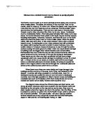
When these occur there are many deaths and huge damage to the buildings and the economy of the area, even if they are prepared for the disaster. Countries with large population in confined areas, even if in a developed country are usually the ones at most risk even in developed countries due to the high population in cities in hazard zones and building on unsuitable land such as floodplains which flood during floods and on low coastal land which can be easily flooded when tsunamis occur.
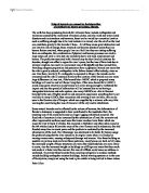
The diagram below shows the different plates and their names, and shows all active volcanoes which have erupted in the last 50years which are identified by the red spots on the map and as can be seen, they occur on plate margins where the magma can rise to the surface. Also the Ring of Fire is pointed out which is an area in the North Pacific Ocean which is prone to lots of tectonic activities. The case studies I will use to discuss whether tectonic hazards are purely a physical process are the Kobe Earthquake, Japan in 1995 and the Izmit earthquake Turkey, in 1999.
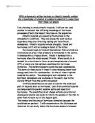
On Tuesday, January 17th 1995, at 5.46 a.m. (local time), an earthquake of magnitude 7.2 on the Richter scale struck the Kobe region of south-central Japan. This region is the second most populated and industrialized area after Tokyo, with a total population of about 10 million people. The ground shook for only about 20 seconds but in that short time, over 5,000 people died, over 300,000 people became homeless and damage worth an estimated £100 billion was caused to roads, houses, factories and infrastructure (gas, electric, water, sewerage, phone cables, etc). So why did the earthquake occur at Kobe? It was because of the three crustal plates which meet near to the coast of Japan. Close to Kobe, the denser oceanic Philippines Plate is being subducted beneath the lighter continental Eurasian Plate at a rate of about 10 centimetres per year. The Japanese island arc has been formed from the molten magma released by the melting Philippines Plate. Earthquakes are very common here and happen because of the friction resulting from the two plates colliding along this destructive margin. [In 1923, the Great Kanto Earthquake killed 140,000 people in this area.] The great destruction which resulted from the 1995 Kobe Earthquake was due to the shallow depth of the focus which was only about 16 kms. Below the surface and the fact that the epicentre occurred close to a very heavily populated area. Seismic shockwaves travelled from Awaji Island (the epicentre) along the Nojima Fault to the cities of Kobe and Osaka. The earthquake that occurred here killed just over 5 thousand people which were greatly reduced from the number killed in 1923. The main reason for this is the increased in awareness and prediction techniques in the country of Japan which is an MEDC. There is clear evidence that the death toll has been reduced here due to the awareness and funding that MEDC’s give to hazard prediction. But still the death toll could be reduced if there were less people living in the city. But there is very little flat land in Japan as it is mainly a mountainous area. Most of the people who where injured lived and worked in structures which weren’t protected from such hazards as earthquakes. As can be seen in the picture, the older wooden buildings collapsed easily under the force of the earthquake as they didn’t have good foundations and anyone inside would be seriously injured or killed which has accounted for the high death toll. This next picture shows a good contrast with the types of building and how money and awareness has help save lives in Kobe after the experience of the first large quake. But even structures which where supposed to be resistant to the quake collapsed causing injury and death. This brings up the issue of whether these features are safe and whether they should have been built in Kobe in the first place knowing that it is in a hazard region.
Kobe Highway which travelled above ground through the city collapsed in several places.
In turkey there was a different situation altogether. The earthquake which struck the Kocaeli province of north-western Turkey on Tuesday, August 17, 1999, at 3:02 a.m. local time was of magnitude 7.4 on the Richter scale. The cause of the earthquake was the sudden breakage, or rupture, of the Earth’s crust along a western branch of the 1,500-km-long North Anatolian fault system. The total length of the fault rupture was about 110 km. The region hit by the earthquake is the industrial heartland and the most densely populated section of Turkey. According to official Turkish government estimates, the earthquake caused 17,127 deaths and 43,953 injuries, and displaced more than 250,000 people. Approximately 121 tent cities were required for emergency housing. Approximately 214,000 residential units and 30,500 business units were lightly to heavily damaged. Most of the collapsed and damaged buildings were of reinforced concrete construction. Their poor performance was due primarily to the poor quality of construction and failure to enforce the local building code. There was major structural damage even to new buildings and structures which could have been made safe and resistant if the awareness and money was there to do so. Although Turkey is a MEDC, there are many regions which are very poor and the region where the earthquake struck one of the poorest in the country. This means that many people would be living in poor quality housing, often overcrowded, with poor services and little if any evacuation procedures if there was to be an earthquake.
Dams, roads and other transport connections, and buildings fell easily due to effect of earthquake, further damaging the already poor economy and forcing many to live in tents and temporary shelter where many stayed for a long time as they couldn’t afford to buy or build new houses.
Looking at the situation of both earthquakes, there are many ways which could have avoided the death tolls. The main problem is that too many people live in small spaces, in Japan they live there because there is little flat land and in Turkey they live there so they can be near industry to provide jobs and income. The buildings in both situations could have could have prevented deaths if older buildings where rebuilt or supported, and if they where on a smaller level because few storey buildings are less likely to collapse than the high rise flats and office blocks which are usually built in confined spaces. These are usually built for poorer people and business but if planning was thought through there would be fewer deaths as these structures could be built in other areas which have a low risk. Even though this is not possible in Kobe due to its lack of low land, there still could be changes to buildings and people have been educated what to do if ever the situation was to occur and this is why the earthquake had only a third of the death toll which was seen in Turkey. This clearly shows that simple things can which humans can do to avoid disasters are effective and protect people from injury. I think that tectonic risk could be severely reduced if populations thought out the places they choose to live and then I believe that many lives would be saved as there would be less risk of people getting caught up in the natural physical tectonic hazards which occur and not try to fight them.