Does Kenya Get the Full Benefit From its Tourist Industry?
My coursework task is to write a report about Kenya to show that I have studied Kenya and its tourist industry and can make a judgement about how much Kenya benefits from the tourists that visit the country.
Kenya is an equatorial country located on the east side of the continent of Africa bordering Somalia, Ethiopia, Sudan, Uganda, Tanzania and the Indian Ocean. Kenya is also bordered by Lake Victoria in the west. Kenya lies between 5°N and 5°S and covers an area of 582,646Km². Kenya has an extremely diverse relief with a low coastal plain spanning 536km, inland plateaux regions and multiple mountain ranges and isolated peaks.
Tourism has become the most important part of Kenya's economy accounting for 38% of industry in the developing country. Kenya's main tourist attractions are the many game parks across the country, including the popular Massai Mara reserve and the more exclusive Tsavo National Park. Kenya also offers Golden beaches and 5-star hotels along its 536km of coastline.
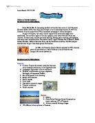
The map below shows the location of Kenya within Africa, Important tourist destinations, Major Game reserves and relief.
Map of Kenya and the Surrounding Countries
Kenya lies on the equator but the annual rainfall is unusually low and varies from year to year. This is due to the seasonal winds blowing the intertropical cloud and rain relatively quickly across Kenya in April and October and the Monsoons taking a track parallel to the coast and passing over large areas of land before reaching Kenya.
You would expect the temperature in Kenya to be constantly high as it is an equatorial and so the sunlight hits the earth vertically and with more concentration than at latitudes away from the equator all year round, but the average temperatures in Kenya are relatively low compared to other equatorial African countries due to the variation in altitude. Only the low lying coastal areas of Kenya experience constant high temperature associated with equatorial locations.
There are two rainy seasons; March - May and November - December and two dry seasons in between. The country's climate can be divided into four regions:
Coastal region
The temperature and humidity stay relatively high all year round but the offshore wind and the long days make the area bearable. It receives some rain all year round mostly in the small hours of the morning.
The Northern Frontier and Lower Inland Plateau
This section of the country experiences a low annual rainfall considering its equatorial location (usually below 500mm). The temperatures are high throughout the year and the humidity low.
The Kenya Highlands
This region to the west of the country is the most agriculturally productive land in the country. As Kenya is a developing country with a huge slice of its industry being primary the region is also the most densely populated.
Kenya's Double rainy season does feature in the region but rainfall is moderate and exceeds 1250mm only on the highest parts of the area. The region experiences its lowest temperatures from June to September, the nights being described as "chilly".
My coursework task is to write a report about Kenya to show that I have studied Kenya and its tourist industry and can make a judgement about how much Kenya benefits from the tourists that visit the country.
Kenya is an equatorial country located on the east side of the continent of Africa bordering Somalia, Ethiopia, Sudan, Uganda, Tanzania and the Indian Ocean. Kenya is also bordered by Lake Victoria in the west. Kenya lies between 5°N and 5°S and covers an area of 582,646Km². Kenya has an extremely diverse relief with a low coastal plain spanning 536km, inland plateaux regions and multiple mountain ranges and isolated peaks.
Tourism has become the most important part of Kenya's economy accounting for 38% of industry in the developing country. Kenya's main tourist attractions are the many game parks across the country, including the popular Massai Mara reserve and the more exclusive Tsavo National Park. Kenya also offers Golden beaches and 5-star hotels along its 536km of coastline.
The map below shows the location of Kenya within Africa, Important tourist destinations, Major Game reserves and relief.
Map of Kenya and the Surrounding Countries
Kenya lies on the equator but the annual rainfall is unusually low and varies from year to year. This is due to the seasonal winds blowing the intertropical cloud and rain relatively quickly across Kenya in April and October and the Monsoons taking a track parallel to the coast and passing over large areas of land before reaching Kenya.
You would expect the temperature in Kenya to be constantly high as it is an equatorial and so the sunlight hits the earth vertically and with more concentration than at latitudes away from the equator all year round, but the average temperatures in Kenya are relatively low compared to other equatorial African countries due to the variation in altitude. Only the low lying coastal areas of Kenya experience constant high temperature associated with equatorial locations.
There are two rainy seasons; March - May and November - December and two dry seasons in between. The country's climate can be divided into four regions:
Coastal region
The temperature and humidity stay relatively high all year round but the offshore wind and the long days make the area bearable. It receives some rain all year round mostly in the small hours of the morning.
The Northern Frontier and Lower Inland Plateau
This section of the country experiences a low annual rainfall considering its equatorial location (usually below 500mm). The temperatures are high throughout the year and the humidity low.
The Kenya Highlands
This region to the west of the country is the most agriculturally productive land in the country. As Kenya is a developing country with a huge slice of its industry being primary the region is also the most densely populated.
Kenya's Double rainy season does feature in the region but rainfall is moderate and exceeds 1250mm only on the highest parts of the area. The region experiences its lowest temperatures from June to September, the nights being described as "chilly".