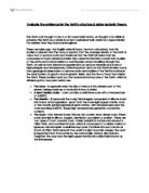
The crust of the earth is not very thick, (refer to figure 1), it is only 5 to 70km thick. Therefore, the knowledge of the crust is far greater & more widely known. As science has improved so has our concept of the Earth, in the late 1960’s, people had begun to notice how the continents either side of the Atlantic Ocean seemed almost to fit together. As the evidence built up it allowed Alfred Wegener to publish his theory in 1912 suggesting that the continents were once all joined together in an ancient supercontinent he called Pangaea. He proposed that the continents had drifted apart (later called continental drift) & have occupied their current position on the globe. This theory seemed to support the idea that the continents were once joined.
This evidence includes:
-
Continental Fit– some continents (such as the western seaboard of Africa & the eastern seaboard of South America) seem to fit together if placed beside each other.
-
Geological Evidence – rocks of the same age and type and those which display the same formations are found in South-East Brazil & South Africa; also the trends of the mountains in the Eastern USA and north-west Europe are similar when they are placed in their old positions. There are similar glacial deposits which are found in Antarctica, South America & India (from the last ice age); now they are many thousands of kilometres apart.
-
Climatological Evidence – places as far apart as Antarctica, North America, Svalbard & the UK all contain coal deposits of a similar age, which were formed in tropical conditions. Yet they are not in tropical zones anymore & must have drifted since the Carboniferous period.
-
Biological Evidence – findings have shown that there have been similar fossil formations on either side of the Atlantic. For instance, the reptile Mesosaurus, are only found in South America & Southern African sediments of the Permian age (around 280 million years ago)
Although, Wegner had convincing evidence that continental drift was occurring, there was a flaw in this theory. The flaw was that there was no explanation of the mechanism by which the continents could move over an obviously solid Earth. It was not till the end of the Second World War that major discoveries began to take place. In 1948, a survey of the Oceanic (Atlantic) floor revealed a continuous ridge (later called Mid-Atlantic ridge) running largely North to South. It proved to be around 1,000km wide, reaching heights of 2.5km, & was composed of volcanic rocks. Similar submarine mountain ranges were later found in the Pacific Ocean extending over 5,000km. Further surveys of the ocean floors during the 1950’s showed surprisingly regular patterns of palaeomagnetic striping about the ridges. When lava flows out of the mouth of a volcano, the magnetic domains within the iron-nickel minerals in the lava are aligned with the magnetic field of the Earth (at that time). Without any major disturbance these rocks can accurately continue to record the Earth’s polarity at the time of the eruption. According to studies, the Earth’s polarity changes about every 400,000years, these show up on the rocks as they are in bands or stripes of normal and reverse polarity rocks are mirrored on each side of the mid-ocean ridges. This suggests that new rocks are being added equally on each side. This kind of plate boundary is called a constructive as it is creating material (by bringing it up from the Asthenosphere). As a result, this theory provided a reasonable explanation for landforms such as the Hawaiian Islands (ring of fire); fold mountains (the Himalayas) & oceanic ridges (the Mid-Atlantic ridge).
An example of this is the mid-Atlantic ridge where the North American Plate is moving away from the Eurasian Plate.
Other than claiming that the oceanic floor was getting bigger and bigger, the theory did not explain that if this is true then why is the Earth not getting bigger? There was no evidence that pointed towards the planet growing in size as the ocean floor builds up, therefore, oceanic crust must be consumed elsewhere. This led to new questions, such as how & where is this happening? These questions led to the discovery of huge trenches where large areas of the ocean floor were being subducted, such as those around the fringes of the Pacific Ocean.
-
Subduction zones (convergent boundaries) occur where one plate is much denser than the other one & is forced down when the two plates collide and one is force under the other due to pressure building up and the lighter material on top of the lighter material.
- These zones there are often noted for their high rates of volcanism, earthquakes, and mountain building. This is because Subduction processes result in melt of the mantle that produces a volcanic arc as relatively lighter rock is forcibly submerged. i.e. Indo-Australian Plate under the Eurasian Plate, which has led to December 26, 2004 that devastated the areas around the Indian Ocean
Consequently, a new theory about the structure of the Earth was in dire order. Subsequently, Plate tectonics comes into the picture it claimed that the crust was a colossal jigsaw puzzle, which is devised of seven major plates. Yet the true picture is far more complex, with over 50 plates moving at different rates and in different directions. All these plates are in motion (on average 5-10cm/year), but some move faster (up to 18cm/year).The crucial difference here was that not all of the plates were colliding and producing landforms (which are visible today). The centre of this theory lies in the idea that the higher temperatures at the centre of the Earth’s core, and heat released by radioactive decay of elements within the mantle, help create convection currents. These currents cause zones where there is hotter, more liquid magma, which is thought to cause continuous circulatory motion in the asthenosphere that causes the crustal plates to move.
The third type of plate boundary is Conservative plate boundaries, which are also often referred to as passive or slip margins; the reason for this is that (where these two plates meet) the motion of the plates is either parallel or nearly parallel. (An example of this is the San Andreas Fault in California). They are referred to as being slip margins because when these plates rub against each other sometimes the friction in between them builds up to a point where they stop moving entirely. When this usually occurs the plates have become jammed & an immense amount of pressure is needed to separate them again. Once this pressure is released in the form of earthquakes but is not associated with active volcanism.