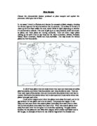
The theory states that Earth's outermost layer, the lithosphere, is broken into 7 large, rigid pieces called plates: the African, North American, South American, Eurasian, Australian, Antarctic, and Pacific plates. Several minor plates also exist, including the Arabian, Nazca, and Philippines plates. This is due to convection currents which cause the plates to move. Convection occurs because the density of a fluid is related to its temperature. Hot rocks lower in the mantle are less dense than their cooler counterparts above. The hot rock rises and the cooler rock sinks due to gravity.
These plates may consist of continental crust, of oceanic crust, or a combination of the two. Most are a combination, with the exception of the three 3 major oceanic plates, which are the Pacific, the Nazca and the Cocos. The remaining major plates are all combinations of oceanic and continental crust, and are named after the land embedded in them - Eurasia, Africa, India-Australia, Antarctica, South America and North America. Continental crust protrudes above sea level as land. It is composed primarily of granite, so is relatively light. Continental crust is a permanent feature of the Earth's surface - it can be created, but it cannot be destroyed. Areas of oceanic crust comprise the deep, relatively flat, sea floors. These are made of basalt and are relatively thin.
The plates are all moving in different directions and at different speeds (from 2 cm to 10 cm per year--about the speed at which your fingernails grow) in relationship to each other. The place where the two plates meet is called a plate boundary. Boundaries have different names depending on how the two plates are moving in relationship to each other.
Places where plates crash or crunch together are called convergent or destructive boundaries. Plates only move a few centimetres each year, so collisions are very slow
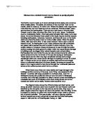
and last millions of years. Even though plate collisions take a long time, lots of interesting things happen. For example, in the drawing above, an oceanic plate has crashed into a continental plate. Looking at this drawing of two plates colliding is like looking at a single frame in a slow-motion movie of two cars crashing into each other. Just as the front ends of cars fold and bend in a collision, so do the "front ends" of colliding plates. The edge of the continental plate in the drawing has folded into a huge mountain range, while the edge of the oceanic plate has bent downward and dug deep into the Earth. A trench has formed at the bend. All that folding and bending makes rock in both plates break and slip, causing earthquakes. As the edge of the oceanic plate digs into Earth's hot interior, some of the rock in it melts. The melted rock rises up through the continental plate, causing more earthquakes on its way up, and forming volcanic eruptions where it finally reaches the surface. An example of this type of collision is found on the west coast of South America where the oceanic Nazca Plate is crashing into the continent of South America. The crash formed the Andes Mountains, the long string of volcanoes along the mountain crest, and the deep trench off the coast in the Pacific Ocean.
Places where plates are coming apart are called divergent or constructive boundaries. As shown in the drawing above, when Earth's brittle surface layer (the lithosphere) is pulled apart, it typically breaks along parallel faults that tilt slightly outward from each other. As the plates separate along the boundary, the block between the faults cracks and drops down into the soft, plastic interior (the asthenosphere). The sinking of the block forms a central valley called a rift. Magma (liquid rock) seeps upward to fill the cracks. In this way, new crust is formed along the boundary. Earthquakes occur along the faults, and volcanoes form where the magma reaches the surface.
Where a divergent boundary crosses the land, the rift valleys which form are typically 30 to 50 kilometres wide. Examples include the East Africa rift in Kenya and Ethiopia, and the Rio Grande rift in New Mexico. Where a divergent boundary crosses the ocean floor, the rift valley is much narrower, only a kilometre or less across, and it runs along the top of a midoceanic ridge. Oceanic ridges rise a kilometre or so above the ocean floor and form a global network tens of thousands of miles long. Examples include the Mid-Atlantic ridge and the East Pacific Rise. Plate separation is a slow process. For example, divergence along the Mid Atlantic ridge causes the Atlantic Ocean to widen at only about 2 centimetres per year.
Places where plates slide past each other are called transform or conservative boundaries. Since the plates on either side of a transform boundary are merely sliding past each other and not tearing or crunching each other, transform boundaries lack the spectacular features found at convergent and divergent boundaries. Instead, transform boundaries are marked in some places by linear valleys along the boundary where rock has been ground up by the sliding. In other places, transform boundaries are marked by features like stream beds that have been split in half and the two halves have moved in opposite directions.
Perhaps the most famous transform boundary in the world is the San Andreas fault, shown in the drawing above. The slice of California to the west of the fault is slowly moving north relative to the rest of California. Since motion along the fault is sideways and not vertical, Los Angeles will not crack off and fall into the ocean as popularly thought, but it will simply creep towards San Francisco at about 6 centimetres per year. In about ten million years, the two cities will be side by side!
Although transform boundaries are not marked by spectacular surface features, their sliding motion causes lots of earthquakes. The strongest and most famous earthquake along the San Andreas fault hit San Francisco in 1906. Many buildings were shaken to pieces by the quake, and much of the rest of the city was destroyed by the fires that followed. More than 600 people died as a result of the quake and fires. Recent large quakes along the San Andreas include the Imperial Valley quake in 1940 and the Loma Prieta quake in 1989.
When continental plates collide head on with other continental plates, the result is upheaval! With both having similar density, neither plate will be forced downwards as happens at the destructive margin. This is known as a collision zone. Movement is slow, in the order of just a few centimetres a year, so there is no massive and sudden collision shock (as might happen in a road accident).
Instead, the gradual forward movement of each plate creates extreme pressures within the leading edges. Over a period of time (long in our human terms, but relatively short in the time scale of the planet) the rock strata deform and become folded (plastic deformation), rising to create mountain ranges.