Tilting (epeirogeny) of the land has led to submergence of several ancient ports in the Mediterranean. Southeast England and the Netherlands have increased risk of marine flooding. The emergence of mid Atlantic ridge could have resulted in a eustatic rise in the sea level.
Changes in Sea Level Affect:
- Shape of the coastlines and formation of new features by increased erosion and deposition.
- The balance between erosion and deposition by rivers resulting in drowning of lower sections of valleys and rejuvenation of rivers.
- Migration of plants, animals, and humans.
Landforms Resulting From Submergence
- Rias - these are drowned river valleys, which are sheltered, winding inlets, and occur in the southwest of Britain at the river Fal. Here the sea goes in 18km to Turo and then it deposits sediment due to balance rejuvenation, E.g. The Loe was a ria before a bar blocked it across its mouth.
- Dalmatian Coastlines - these are drowned river valleys, which are parallel to the coast, E.g. The Dalmatian Coastline, Yugoslavia.
- Fjords - these are drowned glacial valleys which are deep, long, narrow inlets with steep and often straight sides E.g. Sogne Fjord which is 100km long and the mouth is a shallow seaward entrance known as a Threshold.
The threshold causes many things to happen like:
- When the glacier began to float it stopped eroding.
- The glacier had a thin snout and this was less erosive.
- Large terminal moraine.
- Some thresholds are solid rock and some are morangle (deposited material.)
- Fjards - these occur when low land pre-glacial areas are flooded and they become shallower, wider, and they have less branches, E.g. Oslo, Norway, The Boltic Coast, Sweden, and Strangford Lough, Northern Ireland
Landforms Resulting From Emergence
- Following the global rise in sea level and still occurring in several parts of the world today there was an isostatic uplift of land as the weight of the ice sheets decreased. Landforms created as a result of land rising relative to the sea are raised beaches and erosion surfaces, E.g. Dyfed the Gower Peninsula, South Wales, Cornwall. All of these places had flat upland surfaces normally between 45-200m above the sea level.
- Raised Beaches / Shorelines - as the land rose former wave cut platforms and beaches were raised above the waves, E.g. In west Scotland it degraded cliffs and wave cut platforms, old cliff line which contained arches and stacks.
- E.g. At Kings cave, Arran, 8m of raised beach with former notches and caves. Isostatic adjustment is not constant and is in fact slowing down due to it nearly finishing rebounding. The amount of uplift is decreased from the centre of the ice caps.
Coastal Deposition
Deposition occurs where the inputs exceed the outputs.
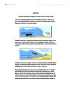
Spits
- A long narrow accumulation of sand with one end jointed to mainland and the other projecting out to sea or across an estuary. E.g. Spurn Head / Hirst Castle (South Coast) Blakeney Point.
Different Types of Spits
- Sandy Spits - formed by constructive waves.
- Shingle Spits - formed by destructive waves.
- Composite Spits - shingle deposited before the finer sand (made of both).
- Spits are formed by longshore drift, which carries material along the coast and continues in the same direction when the coastline retreats E.g. Estuary.
Spurn Head, Holderness Coast
- A drift lined spit formed when longshore drift occurred to the south. The spit receives sediment drifting south as far north as Flambrough Head. It receives glacial deposits that are as easily eroded and a abundant sediment supply. The wind is from the north and northeast and that is why the drift is to the south. It is projecting into a Humber Estuary. In the slack water the finer sediment is stored. Due to the projection into the estuary the Humber is diverted south. The spit has moved west due to the eroding coastline.
Hooked or Re-curved Spits
- As spits build out into deep water they require increasing volumes of sediment to build above the high mark. The tip or distal turns towards the land where it's shallower. If it built out in deep water it would be eroded. Once formed hooks are sheltered from the dominant waves by the spit and become permanent curves also formed by the second dominant wind.
Double Spits
- Are spits, which extend from an embayment this may be due to two dominant winds. Due to a spit extending across a bay (bar) and it gets breached E.g. Christ Church Harbour in Bournemouth Bay at one point the southern spit spreached right across the harbour.
Forelands
- A cuspate foreland is a complex depositional feature formed when longshore drift is from two directions, which meet to produce a series of ridges at right angles to each other. This forms a low-lying triangle area E.g. Dungeness.
2000 years ago when the sea level in southeast England was 2m lower than it is today, the coastline at Dungeness was 15km inland. The wind and the fetch were both over 500km from the southwest. Beach material is carried by Longshore drift from west to east along the channel coast. Some fiercest storms are when the wind blows from the northeast the second greatest fetch is 600km in storms shingle is carried east to west. Storm waves have built up shingle ridges each ridge protects the one behind it. The triangle feature is a site for Lydd Airport and power stations.
Bars
- If a spit extends across a bay it links two headlands and straightens the coastline. E.g. Chesil Breach off the Dorset Coast smoothes 30km of coastline.
Tombolo
- This is when a spit joins an island to the mainland E.g. Chesil Links, The Isle of Portland and Llanddwyn Island.
Barrier Beaches and Islands
- The most extensive extends from New Jersey down the east coast of the USA to include Cape Hatteras and Florida Miami beach is easily identified. The beaches form as offshore bars of sand, which accumulate below the low tide mark and move inland. The shallow water generates constructive waves, which transport material landwards creating a long smooth coastal feature topped by sand dunes and separated by a lagoon.
Sand Dunes
- Longshore drift may deposit sand in inter tidal zones. As the tide ebbs the sand dries out when the wind blows from the sea the sand will move up the beach by saltation. This occurs when the prevailing winds come from the sea and large tidal range, which exposes more sand at low tides. Sand can become trapped by seaweed and driftwood on berms and high spring tides. Plants colonise the area stabilising the sand and encouraging accumulation. The regolith has a high PH due to the calcium from the seashells.
Embryo Dunes
- Likely to develop and the surface becomes arid due to percolation in the sand. Marram grass is featured it has long roots to tap underground water supplies. Spinifex has long growth which reduces transpiration in strong winds these are the first plants to colonise the sand dunes. As more sand accumulates, embryo dunes join up to form Foredunes, which can reach a height of 5m due to the lack of humus colour = yellow dunes. These are grey as humus and bacteria from plants and animals are added and become acidic and vegetation covered. They reach 10-30m before their increasing distance from the beach cuts off the supply of sand. There maybe several parallel ridges of old dunes separated by low-lying damp slacks. Health plants dominate the area as acidity humus and moisture contents increase. Paths expose areas of sand the wind funnels along these paths and blowouts may form.
Salt marches
- Where there is shelter in river estuaries or behind spits, silt and mud are deposited by the rising and falling tide or the river. Plants like algae and salicornia can tolerate the submergence and the high levels of salinity. They trap more mud around them allowing the slope zone to remain exposed for longer periods between tides. Spartina grows all year round and has colonised most estuaries. The land at the side is marked by a cliff above it is the sword zone which maybe covered by sea for less than one hour. Seawater collects in hollows, which increases following evaporation and enlarging into saltpans. As the tide retreats water drains into creeks.
Headlands & Bays
- These are alternating bands of more and less resistant rock and are exaggerated and destroyed by wave action (may not be a large difference but will show after a long period of time).
- Hard Rock erodes slowly = headland.
- Soft Rock erodes faster = bay.
Due to wave refraction energy will be less concentrated on the hard rock (headlands) and this will slow down the erosion of the bay.
Case Study - Wilworth Cove, South coast of England.
It has a narrow entrance due to hard rock been resistant to erosion (Portland Beds). Also featured is a circular bay due to the Wealdon Beds that are soft and easily eroded. Chalk is relatively more resistant to erosion and this is slowing down the northward erosion movement. The bay will enlarge in the east and west directions due to this been soft rock (Warbarrow Bay).
Wave Cut Platforms
- Waves erode the base of cliffs by hydraulic action, abrasion and solution. This results in a Wave Cut Notch at the high tide line. The cliff is undercut by stress and tension on the cliff so therefore it will crack and collapse. This is repeated and the cliff retreats landwards leaving a gentle sloping wave cut platform. The platform cuts across no matter what type or structure the cliffs have. Some pools may form where solution occurs on dissolvable and if there’s a crack in the rock. The wave cut platform is covered in debris. As the platform widens the waves break further out to sea so they have to travel over a wider area and so the energy is dissipated therefore erosion at the headland is reduced.
- There is a hypothesis that wave cut platforms can’t exceed over 0.5km in width. Instead wave energy is used for attrition to reduce the size of debris on the platform. Abrasion lowers the platform level and erosion of the headland continues again.
The Erosion of the Headland
- The headland is made of resistant rock (chalk / granite). The base of the cliff is eroded to form a wave cut notch or an abrasion notch. A Geo may form if the sea cuts inland along a joint by hydraulic acts and abrasion. A Geo is a narrow steep sided inlet. A cave is formed by a wave cut notch eroded backwards and side wards to form a cave by hydraulic action and abrasion. These are best formed in a macrotidal environment with storm waves and resistant rock.
- Caves - will not form in weak and unconsolidated rock, E.g. Bolderclay because the land will slide down. In resistant rock with vertical faults blowholes may form. A blowhole is when the sea enters the cave and water and air are shot up the vertical joint.
- Arches - Arches are formed as the cave wears backwards along a fault by hydraulic action and abrasion right through the headland.
- Stacks - These continue to erode at the arch and weathering at the top, it cracks and falls into the sea and this leaves the tip of the headland.
- Cave E.g. Flambrough, Swanage (Chalk).
- Arch E.g. Flambrough (Chalk).
- Stack E.g. Old Harry needles, Flambrough (Chalk), Old man hoy (Old red sandstone).
Coastal Transportation
There are four different types of transportation and each one carries a different size load.
- Trachon - these are large boulders that are rolled along by the currents.
- Saltation - pebbles are bounced along by the waves and current.
- Suspension - small stones and sand carried within the water by currents and waves.
- Solution - particles dissolved within the seawater.]
Currents
Currents help to remove sediment from river estuaries and costal erosion; E.g. If there is no current at the end of a river a Delta might form. There is three types of currents;
- Longshore drift on the beach
- Longshore drift off the beach
- Rip Currents.
Longshore Drift on the Beach
- Beaches where waves approach at 90 degrees are called Swash Aligned Beaches and therefore there will not be much of longshore drift. Instead the material is transported up and down the beach. E.g. Storm Bay in Tasmania. Swash aligned beaches are rare and Longshore drift is the movement of sediment along the beach. When a wave breaks the swash carries the material up the beach in the direction of the wind. This is a diagonal movement up the beach then the backwash pulls material back down at a right angle due to gravity. This results in a zigzag migration of sediment along the beach by the processes of Saltation and Trachon called longshore drift. Material that is carried a long distance becomes smaller, rounder, and sorted according to its size. Longshore drift is dependent on the wind direction E.g. On the south coast of Britain the maximum fetch and prevailing wind are from the southwest so the drift is easterly.
- At Holderness Coast the maximum fetch and prevailing wind are from the northeast so therefore it moves south.
Longshore Current
- Is a current in the water beyond the influence of the waves where material is carried in suspension (mud and clay) along the coast in the same direction as the prevailing wind.
Rip Currents
- These are submarine currents formed where a ridge (sand / rock) runs parallel to the shore but contains gaps. As the tide retreats the water is funnelled through the gaps that are deepened and widened by abrasion and hydraulic action. Over time the rip currents will decrease in strength as the gap becomes wider and deeper.
Coastal Deposition
- Deposition occurs where the inputs exceed the outputs. Most features are shown below.
Cliffs -
Material is weathered from the cliffs and it then falls into the sea. If it is removed from the slope base by the waves then the cliff is vulnerable to erosion and therefore the waves energy is used for attrition to break material down so it can be transported away this occurs when there is;
1 Mass wasting -
This is where large amounts of material slump down the cliff and the cliff becomes less steep.
If there is a lot of wave energy, abrasion occurs at the foot of the cliff. In a macrotidal range (Britain) an abrasion notch is formed i.e. an undercutting of the cliffs at the high tide line.
2) Plunging Cliffs -
These descend directly into deep water and therefore are hit by unaltered sea waves. Wave energy does not erode but is instead reflected away. The advancing of reflected waves interferes to give a standing wave (Clapotis). This makes it appear as if the wave doesn't advance.
3) Wave Reflection
4) Slope Over Wall Cliffs
- A slope is formed in periglacial conditions i.e. if a cold climate occurs there will be a lower sea level subject to mass wasting.
- Sea level rose. Erosion at the base of a cliff, which first removed debris, then commenced erosion forming the vertical cliff (wall) E.g. Devon and Cornwall.
5) Rock Lithology and Structure -
Strong control over the profile and plan of the cliff. Profile - controlled by the angle of the bedding plain. Plan - is due to the general tectonic trend. If the faults are at 90 degrees this equals headlands and bays - Atlantic Coastline. But if the faults are running parallel to the elongated coast this equals a Dalmatian coastline. Resistant rock = slow erosion. Soft and less resistant = faster erosion. Many faults = friable. No faults = massive.