The top of the sea wall is a flat area that has been built up by beach nourishment and so the pebble roundness and size have no link. The pebbles in this area have been transported from the east end of the beach where they were deposited by longshore drift. Longshore drift moves material form the west end of the beach to the east end of the beach; this means that material builds up at the west side of the beach. This material is then redistributed due to beach nourishment.
The defence has the second largest pebbles and the largest gradient. The bigger the pebbles on a beach the steeper it becomes. This is because the pebbles take up more room and that there is a bigger space between them.
The foreslope has the largest pebbles and theory, as outlined previously, states that it should therefore have the largest gradient. However it only has a gradient of 2° downward, this unusual as the larger the pebbles the more space they should take up. But at this part of the beach the pebbles were not as deep as they were at the defence. The defence was also the slope of the sea wall, which would give it a steeper gradient.
The backslope has quite a large gradient of 8° downwards and it follows the theory by having quite large pebbles at 21.8mm.
The sand and shingle has the smallest pebbles and a gradient of only 2° downwards, the pebbles were quite sparse here as they were near to the sea.
The results that were taken do not match the pattern that is expected from a shoreline investigation such as this. According to the theory and preliminary work that was completed before the fieldwork, the pebbles should become smaller and rounder nearer to the sea due to attrition. Attrition is when waves make rocks and pebbles on the beach collide and break up into smaller pieces.
The pebbles are also smaller closer to the sea due to the tide and wave action on the beach. The swash of the wave pushes material up the beach and the weak backwash can only pull smaller pebbles back with it. These are constructive waves. Destructives waves have a weak swash that does little beach building and a strong backwash, which scours the beach of sand and shingle.
The bigger the pebbles are the weaker the backwash. This is because the waves lose energy as it flows between the spaces in the pebbles. The bigger the pebbles are the bigger the spaces between them so more energy is absorbed.
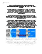
The beach is arranged in steps due to both natural and human activity. The sea wall and defence have these gradients due to human activity. The pebbles there cover the old sea wall. The foreslope, backslope and sand and shingle have this form because of natural, tidal activity. The tide would push pebbles and material up the beach and less would be pulled back by the backwash, some would be out of reach of the backwash.
5a.Two cliff locations were visited on the field trip to show the difference and speed of erosion on different materials.
The cliffs at Cliff End are mainly made of clay. They have eroded in a curved shape, the middle has receded faster, clay is easily eroded and it has formed a bay. The cliff has sunk slightly due to a fault in the sandstone, it has sunk about 4m. There are around three faults running through the cliff at this point but only one is visible.
The cliffs at Fairlight Cove are a clay and sandstone mix, but mainly sandstone. There has been a landslip which was graceful, one section of the cliff has simply moved down. It is a low cliff with not too much to erode and is about twice the height of a house. Fairlight Cove also has many houses along the cliff edge. Below one cottage, Haddocks cottage, runs another geological fault, in fact Fairlight Cove sits between two geological faults.
5b.At Cliff End the top of the cliff is no longer eroding because grass and plants can be seen to be growing and overhanging. These plants cause freeze/thaw erosion because their roots crack the rock and then water collects there. The water freezes and expands, cause the cracks to expand and sometimes chunks of rock break off. Rock is also blown away as the loose bits become exposed and weakened. The cliffs at Cliff End have eroded unevenly due to the fact that they are a clay and sandstone mix, this means that the clay has eroded faster then the sandstone and so creates a jagged effect.
At the foot of the cliff there is a wave cut platform and undercutting which has been formed by abrasion. Abrasion is when the waves use debris and pebbles to erode rock faces. This abrasion can form caves over a long period of time, which is what has happened at the base of the cliff. Most of the base of the cliff protrudes because it is a stronger, more resistant layer of sandstone.
Beach construction does not occur at this point because of longshore drift. Material is not deposited here because it is carried further up the beach where the sea wall and groynes are. There is some shingle here but it is quite narrow at this point. The wave cut platform extends further out then the beach.
The cliffs at Fairlight Cove at much further back then the ones at Cliff End. Erosion has been fiercer and the cliffs have retreated faster. There are houses at the top of this cliff which are in danger.
6. At Pett Level human activity has concentrated on preventing floods from happening and also to prevent longshore drift. The first measures were taken during the 1930s. In 1931 the first coastal protection plan was drawn up. A wave screen was built to absorb the energy of the waves as they hit the beach at high tide and thus prevent more beach erosion. Preventing beach erosion prevents flooding, as there is more land for the water to cross. The waves were made of timber and have begun to disintegrate now because they have been left to rot. To prevent longshore drift the groynes had been constructed prior to 1931, groynes stop longshore drift by trapping material before it can be moved from one side of the beach to the other.
The old sea wall was constructed in the 1950s when it was decided that the current defences were inadequate, an improved scheme had begun in 1947. The sea wall descends steeply and the face of it is covered in concrete squares, which are secured with bitumen, this allows the wall to give when hit by strong waves. The inside of the wall is clay, which was excavated from he nearby marshes creating three vast man made lakes. The grass on the side of the wall, which faces the road, protects the clay, the steps up the wall were built to stop people from walking on the grass and wearing it away. If the grass was worn away it would expose the clay to the wind and rain and cause the sea wall to collapse from the inside. Along the top of the sea wall is a stony path, which has recently been resurfaced. The groynes were renewed but the wave screen has been allowed to wear away. This scheme prevented Pett Level from flooding but did not stop shingle from being lost at the west end of the beach.
In the mid 1950s it was decided that beach nourishment was a better way of preserving the beach. . Access ramps to the beach were built up the side of the sea wall. Approximately 25,000 cubic meters of shingle was added to the west end of the beach and there has been continual beach nourishment of 20,000 cubic meters a year.
In the mid 1960s it was decided to concentrate on beach nourishment, as this was the best way of stopping damage to the coast behind. Shingle was taken from the east end of the beach, where it had been transported by longshore drift, and placed at the west end of the beach where the process would be repeated again. This winter the shingle has been built up more then normal.
In the 1980s the sea wall was extended to Cliff End. The sea wall at Cliff End is made of pre-cast concrete. The top of it is covered in paving slabs, which have holes in them to trap pebbles and water when the waves throw them up. It is constructed in steps as is shown in the diagram.
The cliffs at Cliff End are made of a mixture of clay and sandstone, mainly sandstone, and were retreating at a rate of 1m a year. The cliffs at Fairlight Glen are mainly made of clay and were retreating at a rate of 1.4m a year, it was retreating faster because clay is a weaker material then sandstone and easier to erode. The erosion was intermittent, a large part of the cliff could collapse, every 8 or 9 years, and then nothing would happen while the sea removed debris from the bottom of the cliff.
The district council responsible for sea defences was not doing anything to protect the cliffs o the houses and road at the top of them. Erosion had been worsening since groynes were built at Hastings and were preventing eastward movement of shingle, this meant that the foot of the cliff had no protection. Three schemes were put forward by a consultant engineer. The cheapest was a temporary plan, which would result in the loss of 11 houses. The most expensive cost £9m and was permanent with extensive sea defences.
The winter of 1987/88 was very bad and early 1988sea road was closed to cars, two houses had to be abandoned and five were untenable. In 1989 permission was finally given to begin to build the defences and by July five houses had been abandoned and Rother’s health committee accepted the proposal by the Fairlight Cove Coastal Preservation Society. This was for a 550m barrier of interlocking concrete blocks of about 7m high along the base of the cliff. 70% of the cost was funded by the government, 12% by the County Council and the remaining 18% by Rother District Council.
The scheme was altered to so that a reef of granite rocks was constructed instead, these blocks trap shingle between them and absorb the energy of the waves. They also prevent the waves from reaching the base of the cliff. It can be seen that the high tide does not reach the base of the cliff because there are plants growing there. The granite was imported from Scandinavia, as this was the cheapest option. Granite is very resistant and so will not erode easily, however the boulders at the bottom have been smoothed by attrition. This shows how much force the cliff was exposed to.
The houses at Fairlight Cove which have moved or were at risk from the erosion of the cliffs are, Windover, Bishopsgarth, Dormers, The Ark, Greengates, Grey Wings, Merrylands and Haddocks Cottage.
Until the end of the 1980s The Ark was a very expensive house with nice gardens. In 1987 there was a bad storm and overnight the cliff eroded up to their backdoor. The owners could not sell it or live in it and could not claim insurance, since it does not cover erosion. Greengates has stayed where it was, 10-12ft from the edge,