Analysis
Caswell Bay
Caswell Bay lies on the south coast of Wales, just southwest of the city of Swansea. The Lower Carboniferous rocks along this coast are responsible for the impressive scenery of the Gower Peninsula. These rocks, part of the Carboniferous Limestone Group, are well exposed on the raised beach platform on the east side of the bay
Rock Type 1 – Caswell Bay, below the Café
The rocks we found at our first locality were mid grey, predominantly thick-bedded, fine- to coarse-grained, burrowed, skeletal packstones, with thin beds and partings of shaly dolomite mudstone and siltstone. The base is taken at the sharp erosional contact between the underlying mudstones and the overlying coarse skeletal packstones forming the lower part of the Formation in South Wales. From all this information, we concluded that this rock was the High Tor Limestone.
Rock Type 2 – Caswell Bay, just south of Rock Type 1
The rocks we found at our second locality were grey in colour, had thin beds, laminations, and were very finely grained. This rock has the High Tor Limestone sitting on top to the north. From this we concluded that the rock was the Caswell Bay Mudstone.
Rock Type 3 – South of Rock Type 2
The third rock type we saw during the trip was dark grey in colour, contained cross bedding and consisted of tiny beads of lime about the size of a pin-head. These are formed around a central nucleus (such as a fragment of shell, or a sand-grain). The layers of lime are concentric, like the leaves of an onion. Some of them appeared rough, this is due to weathering. Ooliths are characteristic of shallow carbonate sandbanks close to the zone which is affected by wave-action at surface. This continual agitation moves the ooliths about and wears the precipitates that form on its exterior into a perfect, bead-like sphericity. From the oolitic texture of the rock we concluded that it was an Oolite, and named it Caswell Bay Oolite due to its location in Caswell Bay.
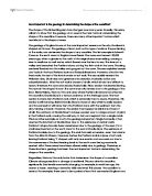
Caswell Bay Thrust
In Caswell Bay, there’s a small thrust known as the ‘Caswell Bay Thrust’ the formation of this is explained in the above diagram.
Eastern side of Caswell Bay towards Whiteshell Point
Whilst still maintaining a fair distance from the cliff, we walked on to the 'corner', where the bay opens out suddenly. Then pause and look back towards the 'angle'. There, picked out by the narrow bedding of the mudstones, we saw a tight little syncline.
On the southern limb of this little syncline, the beds bend steeply upwards, to become vertical as they rise toward the crest of the next upfold.
The neighbouring upfold is a very "tight" anticline, so-called because the angle between its limbs is small. Dolomites lie in its core. There is a deep gully, floored with pebbles, across which the facing strata change from being northerly to southerly dipping. The beds on both sides are very close to vertical. This upfold is the Langland Anticline.
Three Cliffs Bay
Three Cliff Bay is one of the most photographed areas of Gower and is also commonly known as Three Cliffs.
Three Cliffs is breathtaking. Frequented by horses and their riders who enjoy a good gallop on the beach. Three Cliff itself is a common feature that many climbers head for too. Spectacular views but not for the feint hearted. Walks up and down steep sand dunes from Pennard and Penmaen, or through the valley bottom from Parkmill. When the tide is in, it becomes impossible to cross the river heading towards Parkmill, so if you can't climb the sand dunes, take care not to get cut off as the tide sometimes comes in around the sides of the beach and leaves a sandy island in the middle - but not for long.
At three cliffs bay we looked at all the modern sedimentary environments being formed in the area. These included beaches, point bars, flood plains, sand dunes, storm beaches and salt marshes.
At the storm beach we took clast measurements to show the direction of current when the rocks were deposited. The results can be found in the rose diagram below.
Conclusion
All the rock types present at Caswell Bay are carboniferous, and were formed in the same conditions as we currently have in the Bahamas, very warm, tropical, marine, shallow environment. There would have been a lot of animal and plant life at the time, this is shown in the High Tor Limestone with it being very fossiliferous. The mudstone and Oolite were formed around the same location during the same period in time, but they would’ve had slightly different pressures during their formation. The trip to Three Cliffs Bay was also helpful, it showed us what modern sedimentary environments are in the United Kingdom, and more specifically South Wales. It gave us an idea about how rock formations are going on right under our nose, and how there can be so many different environments in an extremely small space.