How useful are urban models to the modern geographer and urban planners?
An urban model is a simplification of a real city. They are used to help us understand more about real cities by showing patterns or processes which in real life may be complex and difficult to identify. They are applicable to a large number of cities rather than one particular city. They are based on the idea that there are similarities between cities.
Geographers use these models to try and identify and explain urban spatial patterns and variations in their structure. Where as urban planners use the models to deal with real life situations such as deciding where to place a new motorway or deciding where to build a new business park.
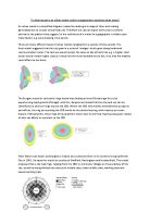
The first urban model to be produced was by Burgess in 1924 he attempted to explain the outward expansion of the city (Chicago) and the socioeconomic groupings of it inhabitants. He did this by splitting the city into five concentric zones: the central business district, transition zone, low class housing, medium class housing and high class housing. He devised these zones by the theory that individual compete with each other for the most favourable locations within the city. This competition was founded on the market for buildings and land: those who can afford the highest prices will get the best and most favourable land.
An urban model is a simplification of a real city. They are used to help us understand more about real cities by showing patterns or processes which in real life may be complex and difficult to identify. They are applicable to a large number of cities rather than one particular city. They are based on the idea that there are similarities between cities.
Geographers use these models to try and identify and explain urban spatial patterns and variations in their structure. Where as urban planners use the models to deal with real life situations such as deciding where to place a new motorway or deciding where to build a new business park.
The first urban model to be produced was by Burgess in 1924 he attempted to explain the outward expansion of the city (Chicago) and the socioeconomic groupings of it inhabitants. He did this by splitting the city into five concentric zones: the central business district, transition zone, low class housing, medium class housing and high class housing. He devised these zones by the theory that individual compete with each other for the most favourable locations within the city. This competition was founded on the market for buildings and land: those who can afford the highest prices will get the best and most favourable land.