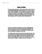
The clinometer registers the angle of the slope, and this is recorded by person A. the distance between person A and person B is then measured using a tape measure, this information is recorded too. Person A then moves to stand exactly where person B was standing. Person B moves to the next break in the slope, and the whole process is repeated again and again until the entire length of the beach is covered.
The data is recorded by making graphs drawn to scale. The graph is drawn by using the angle and length of the slope. This gives a clear cross-section of the beach investigated. Slope profiles provide reliable data which can be used to compare beach sizes, and whether they are prone to erosion or deposition. The graphs will give an overall picture of the type of beach and its formation and what process are affecting it.
The prediction is that the coastline to the west of the harbour arm, where the waves are broken by the harbour arm, will be made up of long, gently sloping beaches with very little cliff erosion. This is because the material is deposited but not removed because the harbour arm prevents material being carried further along the coast to the east. The area of coastline to the east of the harbour arm, the Seaford and Birling Gap coast, will have small, short beaches and considerable cliff erosion. This is because the waves that hit this area have no load to deposit, as the process of longshore drift has been interfered with. The waves remove material from this area of coastline and carry it further along the coast.
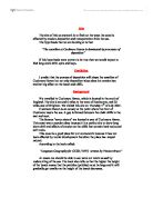
The slope profiles have been to drawn to scale, 1centimetre represents 2metres
The slope profiles reveal what was expected, the beaches on the western side of the harbour arm are longer and have been subjected to more deposition than the smaller beaches on the eastern side of the harbour arm.
Point 1 shows an unmanaged, gently sloping beach 13.4 in length, with a steep chalk cliff. This area appeared to be affected by normal coastal processes.
Point 2 shows a longer beach of 19.4m, with a chalk cliff. At its steepest the beach angle is 16°, levelling out towards the base of the cliff. This area appears to be affected by the harbour arm.
Point 3 shows a beach of 219m long. The beach at the edge of the sea is at an angle of 15°. Sections of the beach drop below sea level. The cliff is no longer being eroded so vegetation has had time to develop, the area of beach leading up to the cliff has now become one with the cliff.
Point 4 shows a shorter beach than point 3, but still quite long at 34m. It slopes gently away from the sea, rising steeply to a level platform leading to the cliff. This stretch of beach has had to be artificially replenished.
Point 5 shows a long beach of 41.2m in length, gently sloping away from the water’s edge and then rising sharply to a level platform. This beach is artificially replenished with imported material.
Point 6 shows a much shorter beach, only 25.8m in length. It is fairly steep, with an angle of 20° at its steepest point. The cliffs here are steeper and have been subject to more coastal erosion.
Point 2 and 3 are longer because the harbour arm is slowing down the process of longshore drift. Longshore drift is the process by which material, such as sand and pebbles, is transported along the coast by waves. Waves approach the shore at an oblique angle, not at right angles. The backwash is at right angles to the shoreline.
The harbour arm prevents longshore drift from carrying out its normal process, so that when it deposits sediment at point 3 it is not able to retrieve it. This causes a build up of beach sediment and in turn longer beaches. Points 1 to 3 show how the harbour arm has slowed down the affect of longshore drift and causes an increase in the length of the beaches.
Points 4 to 6 show a reversed process to points 1 to 3. Because of severe erosion occurring at points 4 and 5 the beaches have to be artificially replenished. If this type of coastal management was not carried out, the beaches would disappear and the sea would begin to erode further inland.
The results of the slope profiles are favourable in support of the hypothesis that “You cannot change one part of the coastline without affecting another”. The harbour arm has had an effect on the beach and cliff formation at Newhaven, Seaford and Birling Gap.