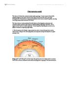
3.2 OCEAN TRENCHES
A trench is formed where two converging plates meet and one slides under the other. The area where the two plates meet is know as the subduction zone. The diagram below shows the two plates meeting, the currents under the plates and the trench being formed.
3.3 VOLCANOES
There are two movements of plates that volcanoes can be formed by, Converging plates and Diverging plates. Here are two examples of converging plates and then two examples of diverging plates.
Here is a diagram of how an Island arc is created. As the downward moving plate sinks deeper it slowly melts. The molten Basalt is lighter that the surrounding mantle material and rises up to reach the surface as a line of volcanoes.
Volcanoes are built on land as the descending plate slides beneath, the continent melts and rises through the continental rocks to reach the surface. This happens on the western side of South America where the Nazca plate slides beneath the South American continents. As it does so volcanoes are produced all along the Andes some of which are still active to this day.
Here are two examples of diverging plates.
Where rising convection currents spread sideways beneath the crust they pull the plates apart and the molten basalt is forced upwards from the mantle cooling at the surface along the plate edges to form new ocean crusts. Between the plates there is a mid ocean ridge which can stand up as high as 13 000 feet from the sea bed. Occasionally the ridge breaks the ocean surface to give an oceanic island such as Island and the Azores which have volcanic features associated with rifting.
The longest ocean ridge is the mid Atlantic ridge from Iceland to Antarctica. As the basalt fills the gap between the plates it solidifies and adds new rock to the edge of the plate causing it to spread outwards. This new crust is continually being created by eruptions of Pillion lava on the sea bed.
Mount Saint Helens
Mount St Helens is in the state of Washington to the north of California. It erupted on May 18th 1980 causing widespread local destruction. In the diagram you can see the evolution of the volcano. The oceanic plate meets with a continental plate. The oceanic plate goes under the continental plate and melts. The molten plate rises and causes a volcanic eruption.
3. PLATE MOVEMENTS
3.1 EUROPE
Look at figure 4 (fig 4) it is a picture taken from a NASA satellite system using a system called SLR (satellite laser ranging) it measures the movement of plates from space. The movements that were measured are represented by the white lines. The blue lines represent the predicted movement of the plates, they are predicted by a system called NUVEL-1. The uncertainties of the velocities range from better than 2 mm/yr to 20 mm/yr are shown as pink error ellipses centred at the tip of each vector. The size of these error ellipses is decided by the number of observations and length of time that the observations were taken. Note that the lines in the Greek and Turkish areas are not very well aligned with those predicted by the NUVEL-1 model. This is because of a dramatic deformational action occurring across this area. We can get a better understanding of the deformational process by using a simple experiment. Imagine a line connected to the tip of a blue line with the tip of the white line. This imagined line shows the motion of the site which would be relative to fixed Europe (this is not true for the three sites in the lower right hand corner of the map since the blue vectors for these sites represent motions of other plates). In another explanation, if we were to "nail-down" Europe, these imagined lines would show the deformational motion.
Aegean Tectonics
Referring to fig 5 the lines shown on this map of Greece are now relative to fixed northern Europe. This shows how the crust in the Aegean is literally stretching from north to south. The block of crustal material along the arc of islands in the southern Aegean is crossing over the African Plate. This is repeated in the south-westward motions for the SLR sites across the region. This is why the Aegean area had a very rounded stretched shape.
3.2 FAR EAST, AUSTRALIA AND THE PACIFIC
As before the white lines on the map represent the movements of the plates measured by the SLR and the blue lines on the map representing the NUVAL-1 prediction. The text refers to fig 6.
Simosato, Japan
The results for the SLR at Simosato, Japan is of interest, because of the recent earthquake in nearby Kobe, Japan. Unfortunately, fig6 doesn't show the SLR lines very clearly as it is hidden below the circle which represents the site, but within this area it is moving south-south-westerly at about 2 mm/yr. If, we do the thought experiment which we did in the previous section, of imagining what the line would be relative to NUVEL-1 simulation for Eurasia (as shown by the blue line), we see, by imagining the line between the tip of the blue line to the tip of the SLR line, we get a line moving north-west at about 30 mm/yr. It can be shown that the Pacific plate and Philippine plate move in similar directions in the area. The SLR results tell us is that Simosato is under a large amount of strain from the offshore collision of the Philippine plate with Japan and the Eurasian plate. This strain is being carried through the area around Simosato to a point further inland where it is building up. This is thought to be the cause of the earthquake in Kobe.
Shanghai, China
At Shanghai, the motion shown in the SLR analysis divides that expected from the NUVEL-1 model for Eurasia motion. The uncertainty for this result is rather large which at this time shows a definite tectonic interpretation. The SLR system at Shanghai is a neighbour to a VLBI system which has been a very successful.
Yaragadee and Orroral, Australia
There are two SLR sites on both coasts of Australia. These are Yaragadee in the west and Orroral in the east. The SLR results for both of these sites shows motion that is very similar with that predicted by the NUVEL1 model for Australia.
Huahine Island, French Polynesia and Maui Island, Hawaii
The SLR movement at Huahine is also very similar to NUVEL-1. Maui is used as one of the base-sites in the analysis where the reference frame is defined. The north component of movement for the Maui site is adopted at the outset to be equal to it's Pacific motion given by the NUVEL-1 model. Additionally, a site in North America is constrained as well. However, the east/west movement at Maui is free to be estimated from the SLR tracking.
3.3 NORTH AMERICA
As before the white lines on the map represent the movements of the plates measured by the SLR and the blue lines on the map representing the NUVAL-1 prediction. The text refers to fig 7.
Sites West of the Pacific - North America Boundary
These involve four sites, two in Mexico, and two in southern California. At the southern tip of the Baja Peninsula is Cabo San Lucas. Here SLR shows a motion which is 52 mm/yr, similar with that predicted by the NUVEL-1 model for Pacific motion. There is an 8 degree difference in the direction, which can bee explained . Further north, at Ensenada, the SLR is very similar to the Pacific NUVEL-1 motion. To the north-east of Ensenada, we cross to the United States and we see that the motions shown by the SLR for the sites at Otay Mountain and Monument Peak are slower than the NUVEL-1 model prediction and differ approximately 10 degrees in direction. This is best explained when it is recognised that the accrual of strike/slip motion of the Pacific plate relative to North America is distributed over a large area rather than a single fault. In other words, as we travel westward across the boundary of the North America and Pacific plates, the change between North American and Pacific motion is fast. As we get further onto the Pacific plate, the plate motion will grow to full rate. There are several faults to the west of the Otay Mountain and Monument Peak these two SLR sites are said to be in the western edge of the plate boundary deformation zone.
Other North American Sites
Working eastward, the motions estimated for Bear Lake, Utah, Platteville, Colorado and McDonald Observatory, Texas all show some slight division from the geologic model. These divisions may be due to a localised surface process. Along the east coast of the United States there are sites in Richmond, Florida, Greenbelt, Maryland and Westford, Massachusettes. The site in Richmond is visited by one of the SLR satellites. It has no uncertainty ellipse because both the north and east areas of it's motion are shown by the NUVEL-1 model The motion of Westford shows general North America plate motion.
3.4 NAZCA AND SOUTH AMERICA
As before the white lines on the map represent the movements of the plates measured by the SLR and the blue lines on the map representing the NUVAL-1 prediction. The text refers to fig 8. There are 3 SLR stations shown on this map. They each are in interesting regions of the world. Beginning with the site at Easter Island, which sits on one of the fastest moving plates, the Nazca plate, the SLR estimate of motion is generally slower than that expected from the NUVEL-1 model. This is because there is a very gradual slowing of the some of the plate velocities over time. The NUVEL-1 model of plate motion is based on geological evidence, particularly, the "speed" of the plates is derived from studying the patterns of a specific magnetic anomaly on the ocean floors. There has been some evidence of a small amount of slowing of the rate of the Pacific/Nazca boundary (along which are the fastest relative plate rates in the world) over the last 3 million years.
Tectonic Motion in South America
The two sites in South America, Arequipa and Santiago, are located in the deforming collision boundary zone between the Nazca plate and the South America plate. The Nazca plate subducts beneath South America and, like the case at Simosato, a bit of the subduction motion is being transferred into a bit of the over-riding plate. This explains why the motions for these two sites appear twisted to the east, when shown with the NUVEL-1 model.
4. REFERENCES
1. Microsoft Encarta
2. Class work sheets
3. Tectonic Page Motion page (http://cddis.gsfc.nasa.gov/926/slrtecto.shtml)