MEANDERS – these are the sweeping curves found in the river’s natural course. They are mainly formed by the sweeping nature of the thalweg in the river. As the thalweg goes from meander to meaner it swings from one side of the channel to the next. The thalweg is always situated towards the edge of the meander. This causes the erosion to be most concentrated at this point and would lead to a river cliff being formed. On the inside edge of the meander where the velocity of the river is not so great deposition would occur, leading the formation of a point bar. Over time the meander tends t become more sinuous until when the normal level of discharge is breached then the river will cut across the meander forming an ox bow lake and the channel would become straight again. Downstream meanders move forwards and outwards
CASE STUDY – RIVER CONWY, WALES.
BRAIDING – this is when the river splits into several smaller streams, between these streams small island forms of deposited materials. A braided channel is the result of extremely erratic river regime. This means the discharge varies greatly over time. When discharge is high then the river is able to hold much more load but when low this material will get deposited and thus the braided channel. They also result from beds with loose sand etc, those which are easily eroded. The overall river is often inefficient as the wetted perimeter is large, the smaller streams allow the river to become more efficient as their individual hydraulic radius is larger and so the smaller rivers erode their banks and the deepening of these smaller rivers can occur.
CASE STUDY – RIVER RHONE, SWITZERLAND.
FLOODPLAINS – These are the flat areas that border a river. They are mainly made up from deposits in the river, silt and sand. This happens when the river floods, it looses a lot of it energy so it will deposit most of its loads to its surrounding areas leaving a fresh new covering of alluvium. Levees will from immediate around the river as the coarser more heavy material gets deposited out of the river. If sea level falls then the river will cut into its own bed. This will cause the river then cut downwards and result in a river terrace, with area less likely to flood.
DELTAS – as a river reaches the sea t velocity greatly reduces. The load that it is carrying then gets deposited as delta. Over time as more and more load is deposited then the deltas will eventually break the surface. The river will then break up as it tries to cope with the change in gradient and sediment loads and so distributaries will form. There are two main types of delta, arcuate (NILE DELTA, EGYPT) and bird’s foot (MISSISSIPPI DELTA, USA)
RIVER CHANNEL MANAGEMENT
How are rivers interfered with?
- building dams
- Reductions in bank side vegetation.
- Irrigation taking water away from the channel
- Dredging to make the channel more efficient
- Making the channel straight in order to reduce flood risk and aid navigation
RIVER BANK EROSION- as talked about before rivers erode and deposit on the bed and banks within its channel. The erosion pat of his can be a significant problem, e.g. people living on the edge of the banks may find that their homes are at risk.
But the advantages
- Adaptation of species to the erosion of the river banks, sand martins.
- Greater diversity of species
- A lot of different habitats
The intervention of humans to the river could increase the amount of erosion to the banks. E.g.:
- reduction in bank side vegetation
- farmers allow animals to drink from the side and so they trampled the side of the river and so they erode away the banks
- recreational overuse
An increased amount of bankside erosion causes more sediment to be added to the water. In turn this could cause;
- Blockage of gravel i.e. fish can’t use the ravel for spawning ground.
- Leaching and eutrophication could occur
- The sediment could block up smaller rivers and so increase the risk of flooding, i.e. it reduces the hydraulic radius.
- Habitats destroyed
- Larger rocks could cause scouring downstream
To stop this we could;
- Provide alternative watering holes.
- Have a buffer zone#
- Provide alternative walks and pathways
River restoration works in reverse to erosion. We often call it sustainable management as the use in present day doesn’t threaten the existence of the river.
CASE STUDY: Kissimmee River, Florida.
River ran slowly and meandered a lot. This meant it was very prone to flooding. After WW II the place became heavily colonised and this meant that more of the floodplain had to be utilised for the use of housing. To prevent a flood risk, the US Army Corps decided to make it less meandering and into a canal. They have trenches in the floodplains to allow the water to drain. The results saw a loss in animals, the fish in the slow flowing areas died because plant would grow there. The government then decided to restore the river and the want to restore the ecological diversity of the area.
COASTAL EROSION
Erosion is one of the foremost processes that shape a coastline. There are many interacting factors;
WEATHERING PROCESSES
As we know, salt weathering, frost shattering, wetting and drying, solution and biological weathering are all prominent here. We find that because of the large amounts of salt and water this happens more effectively at the coastline.
MASS MOVEMENT
Rock falls landslips and rockslides are all common place at the beach. These landforms cause erosion of the beach.
MARINE EROSION PROCESSES
This is the main way in which a coast is eroded. The waves contribute a lot. They are made by the frictional drag of wind on the surface of the water. The fetch, wind speed and wind direction all effect the type of waves tat is created. There are two main types of waves;
- Constructive – the break of these waves is weaker. These waves have a strong swash and a weak backwash. This means that the profile of the beach becomes steeper
- Destructive waves have a strong break. They come down on to the beach meaning that they have a weak swash but a strong backwash which takes the beach sediment back with it creating a shallower beach profile.
This is an example of negative feedback because when the beach becomes steeper the waves are forced to become destructive as the wave orbit is changed by the shape of the beach. But when the beach becomes shallower then the orbit of the wave then causes the wave to become constructive.
Tides also have a big part in the erosional processes of the beach. The tidal range is what affects the amount of erosion that occurs at the beach. Narrow ranges of tide height result in greater amounts of concentrated erosion and deposition.
HUMAN ACTIVITY
Constant walking can wear down rock etc.
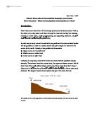
CASE STUDY: LULWORTH COVE
Lulworth cove is a great example of coastal erosion. We find many features in the stretch of the Dorset coastline commonly associated with erosional features. The factors that control the landforms found here the most is the geology of the rock. The rocks here mainly run parallel to the coastline with a lot of variance in respect to the resistance of rocks.
The foremost rock is a limestone called Portland stone. This is an extremely resistant rock and forms a barrier for marine erosion. Like all limestone it is heavily jointed and the cracks in the rocks are exploited by weathering and gradually these will be big enough so the sea can weather and erode the rock behind it, i.e. forming caves.
Stairhole is where the sea has broken through the Portland stone and worked at the shales and clays behind it. We see here that there is an almost vertical wall of Portland stone. The Purbeck beds are heavily folded and have crumbly look.
Durdle door is an impressive arch which has been formed by the sea finally cutting through the rock and forming a hole in the rock. After time the arch will get weathered and finally collapse. It could then leave a stack. This is an isolated outcrop of rock. Overtime these to would get weathered and they would form stumps which are isolated outcrops of rocks exposed only at low tide. As the cliff line retreats all left will be a wave cut platform which is formed by the weathering of waves at high tide and low tide. Again the wave cut platform is only visible at low tide.
As erosion continues on the rocks now exposed with the removal of the Portland stone a bay or cove could be formed.
The coastline at Lulworth cove is heavily indented this could cause wave refractions. This is an important factors as it can located areas of high energy and low energy and therefore we would easily be able tell if erosion or deposition were occurring.
COASTAL DEPOSITION
With coastal deposition the sediment comes from three main sources, fluvial sediment, cliff erosion and offshore sediment.
BEACHES
Berms – these are ridges in up the shore off about 1-3m high. They are formed by storms and extremely high tides, i.e. the spring tides. They are subject to much change.
Beach cusps – these are found between high and low tide marks. They vary greatly in size are formed by the powerful swash and backwash.
Spits – a bank of sand or shingle protruding from the coast into to the sea. They are formed by longshore drift. They are breached easily as they are not protected by soil or land. They usually develop where there is a change in orientation from the coast. The tip of the spit is usually curved due to wave refraction of powerful waves forming a lateral. Over time the spit grows usually with the formation of many laterals and the sediment deposits allow for vegetation to grow i.e. a salt marsh. Often spits can grow very far often covering a bay, this is then called a bay bar. Were a spit links the mainland to an island it is called a tombolo.
Forelands – often in the coast to sediment cells will converge to form a triangular shaped headland, i.e. deposition between the two cells.
THE IMPACT OF CHANGING SEA LEVEL
There are two main types of changes that can undergo land.
Eustatic change is the change in the level of the sea in relation to the land so for example during the ice glaciers locked up a lot of the water in the sea so sea levels would drop.
Isostatic change is the change of sea level in relation to the land. It is when the height of the land sinks i.e. the pressure exerted by the glacier on the land caused them to sink and so the sea levels would rise.
What could happen?
Well with rising sea level we could see chain of islands becoming wiped out also we could find that river estuaries would become larger and wider these features are called rias. Deltas, spits and beaches would all get wiped out. Fjord would be formed when the sea level rises so that a valley is surrounded by straight cliff faces.
With falling sea levels raised beaches not combed by waves would form. New cliffs would also form with the former cliff becoming weathered and a degraded cliff formed here as no undercutting would be taking place.
We must also understand the processes behind vegetation succession. The main principles behind vegetation succession is that
An uninhabited area is fallen upon by highly adapted seeds which grow, e.g. marram grass in a psammosere. These are called the pioneer species. They can cope with the harsh abiotic factors that are experienced here. As the marram grass continue to live and die, they release nutrients from there one decomposing parts i.e. N locked up in the compounds can be used. This in turn results in more humus added to the soil and so the soil will become more fertile. This will allow secondary colonisers to come and inhabit that land, the pioneer species being pushed to the outskirts. As more humus is released into the soil from the plants already growing there more nutrients are available for uptake and the quality of soil increases. This allows the diversity of the area to increase as the oil is able to support many species. This process will reach a point at which no new species would colonise the area again and this community is called the climax community.
There are three main types,
Halosere – this is the succession caused by a harsh semi-aquatic with saline soils e.g. a salt marsh. The pioneer species here are adapted with large stout stem and adaptation to excrete excess salt e.g. eel grass which can also trap debris and silt sediment between their roots. Cord grass then grows on the salt levees which are loose trapped silt and soil. As we travel from the marsh condition in the soil get less saline and drier as the tide can’t reach it. This allows a lot more plants to survive. Here the climax species are shrubs and trees.
Psammosere – the vegetation succession that occurs mostly on sand dunes. They are hostile environments with strong winds blowing slat around, sea spray so sand is quite saline. Soil here develops extremely slowly. The first thing to grow is sea couch grass, the condition become less harsh, increasing pH of soils, marram grass then grows and then the same vegetation succession occurs and the climax community here is the shrubs and trees.
Hydrosere – the vegetation succession occurring in fresh water environment. The pioneer species must be able to cope with the ability to live completely submerged in water. Then other plants that can survive in the shallow water e.g. lilies. These then trap sediment and debris which added to the soil on the bottom of the making is more fertile and thus diversity of plants increases.
RIVER BASIN MANAGEMENT.
The environment agency is responsible for the all of the water present in the Wales and England. They have three main tasks,
- control water resources
- flood prevention
- pollution control in rivers and other water bearing bodies e.g. lakes
Having said this most rivers run through private land meaning that they are the responsibility of the owner but they are advised to consult the environment agency before doing anything to the channel. We also can’t overlook that rivers runs through different counties or even countries, for this a watershed approach is used. This means that the whole basin is managed, i.e. the states in which the water basin falls all work together to sustain the river and make plans together.
Extremes of discharge
The discharge of a river is hardly ever constant. Often antecedent condition means that the amount of water is high so to will the discharge is high. Often after prolonged times of rainfall a river may breach its banks and cause a flood.
1 - Flooding
A river flood is the land inundated with water that is not usually submerged in it; usually the river cannot sustain the amount of water running through it. Either by rapid through flow or overland flows does flooding occur. What causes flooding?
- antecedent condition = prolonged rains
- intense rainfall event
- snow melt
- impermeable bedrock
- steep valley sides
- lack of vegetation
- urbanisation
- Silting up of river banks e.g. after bankside erosion.
Flooding is usually made worse by the activities of man. Most of our activities are usually on a floodplain meaning that they must be constantly monitored. How can we deal with floods?
- basin and channel management
- Reservoirs and dams
- Controlled flooding to prevent intense flooding downstream
- By pass channel to divert water
- Creating embankment so river can sustain more water.
- Channel dredging so river become more efficient and thus can remove water quickly from a basin.
- Channel straightening again to speed up the water flow.
2 - Low flows
These flows are mainly concerned with the discharge of the water being low. River then tend to dry up and fish die etc.
CASE STUDY: River Wylye, Wiltshire.
This river experienced extreme low flows. The water in this area is managed by Wessex water. They examined that trout population in the water were falling and less water meant the river dried up. The cause was the boreholes drilled by Wessex water for abstraction. This caused more water to be taken out of the water table (river runs over chalk [aquifer]) so this caused the water table to fall. They were told to then monitor the aquatic environment, increase river augmentation, a constant rate of abstraction as opposed to more abstraction in the summer.