In deciding which locations the readings are to be taken from, stratified sampling can be used, this means selecting a point from each of the main parts of the course of the river, we selected upper, middle and lower.Due to hidden dangers and potential accidents we had to make safety a major issue so we took many safety precautions including going to the river when water levels weren't dangerously high, choosing a calm day - avoiding hazardous weather. We made sure that we all stayed together. It was essential that we wore warm comfortable clothing with a first aid kit always at hand.
I will assemble the following information by visiting three sites: Chesham Moor, Chenies, and Scots-bridge Mill. Where I will assess the following things :
The Gradient- using a clinometers
The Width – using a tape measure
The Depth- using a meter ruler
The Cross Sectional Area
The velocity- using a Float and Hydro-prop
The Discharge
The Wetted Perimeter-using a tape measure
The Hydraulic Radius
The Manning’s
The Averages
Whilst I am at each site I will take brief notes as well as detailed diagrams of each river and it’s habitat to illustrate a more vivid investigation. I will also read into different sources to help me with my investigation such as the journal the Geographical Review. In addition to this I will be relying on computing resources to help me analyse data.
Before we set out on our investigation we had several aims to consider.
Does the river discharge increase the further from the source?
Is there a relationship between river width and stream velocity?
As the wetted perimeter increases, river velocity decreases.
In my analysis of the River Chess I selected three areas within the river study. They were the Upper, Middle and lower part of the river. I accomplished this by stratified sampling. The readings I received from theseareas
The highest means have been highlighted in the table above, there are a few anomalies in the table above, for example the mean water depth at site three is extremely high to the rest this could be due to the other groups getting their measurements wrong, or it could be due to the water levels rising.
Site’s mean float time again seems high compared to the rest.
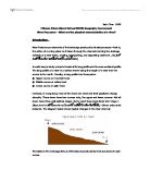
The first site we visited was Chesham Moore; at this site I found that there were a few conflicts that could be examined such as how humans affected the area by building roads and houses. As the river was along side a road, though it was built lower down so there was no risk of a flooding which would harm the habitat. On the other side of the river was much grassland, were a few people brought their pets to leave free, which meant that if the river did flood it would not cause damage as the soil would sink in the water. I noticed that in the river was a fallen tree which added to the inconsistence at this site. This river was shallow as the floor surface could be seen (full with pebbles)
Chenies, the second site that we visited at this site I found that the river was deepest. This river was situated by a field. There was also a farm near by which would explain the few animals there
The third site we visited was Scots bridge Mill, which again was close by to a large field, though there was a fence, along side the river acting as a precaution.
I will compare my hypothesis with my actual results to see if there are any anomalies. The gradient prediction did not match my actual results though this may have been due to the weather changes, as we were taking our measurements the wind was increasing it was only inevitable that there would be a few anomalies. I predicted that the gradient would increase though my result show it stating off fairly high then decrease but then only to increase again.
Although my predictions about the width and the depth were correct as they increased downstream. My predictions about the velocity of the river also were correct as I presumed that the velocity would decrease which it did because the river became deeper and wider. I was also correct about the cross-sectional area as it increase due to the increase in water. The discharge increases downstream as the availability of water increases.