My aim in this investigation is to find out how the variables of the stream vary in accordance with various variables, the main one being increasing distance downstream. Other variables include gradient, velocity, discharge, load size, and angularity and so on. This investigation is being carried out to establish the general character of the river on its course from its source to it confluence with the River Ballinderry at ‘The Point’.
The trip to River Ballymully was worthwhile because I gained geographical knowledge on the topic of “Rivers” and discovered why river characteristics change as you travel downstream. I learnt that at the source of the stream the river’s energy is focussed downwards which creates vertical erosion. This type of erosion causes the channel to become deep and narrow. Further downstream, due to the formation of meanders, the rivers energy is focussed outwards in the form of lateral erosion. This occurs on the outside of the bends. At different stages of a river there are various processes which produce different landforms For example, v-shaped valleys in highland regions and deltas in lowland regions. Knowing this information enables me to understand the hypothesis because each statement involves vertical and lateral erosion in explaining why each characteristic occurs. Another example is stream velocity. Water flows faster through smaller spaces, therefore, because vertical erosion narrows the channel and lateral erosion widens the channel the water flows at different speeds.
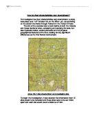
Sites I chose along the River Ballymully
When I decided to study the River Ballymully, I had to make out a list of everything I wanted to investigate, and after deciding on 6 stops along the river, I made out a data collection sheet.
The River Ballymully flows for 14m’s therefore there Sites with the following features were used:
● Varied in the surrounding land use,
● Varied in size and depth,
● Had been changed by mans activities,
● Were natural and unchanged by mans activities,
● Had distinctive erosion and deposition qualities.
List of Sites
Below is a list of sites that we investigated and conducted our experiments at during our investigation:
N.B. These sites were chosen in accordance with their accessibility (as most parts of the river is covered by scrub and vegetation), safety (a class of pupils were involved – very strict safety measures were to be obeyed), and so that each stage of the river’s course was equally covered in our investigation. This will further be discussed in the section of this project called ‘Limitations’.
Limitations
Although the field trip was fairly successful there were many limitations. These included:
- The study sites were all within the same drainage basin
- The different sites were only visited once, on one day, and in one season
The equipment used to take the measurements was very basic and did not enable us to gain precise results. Also, we had no experience of using the Gun Clinometers, which was used to measure the gradient. Therefore the results could not be relied on as being accurate.
The method we followed allowed us to obtain some inaccurate results. For example measuring the velocity. The cork was dropped into the river at point A and the time it took to travel to point B was recorded. If on the third run the cork became caught between dead branches, the time would obviously be slower than if it passed straight through. Under normal investigation conditions the odd result would be discarded but because we were restricted to the amount of time we could spend at each site we were unable to repeat the experiment and the inaccurate result used to calculate an average time.
To improve the work further I would repeat the measurements taken using the following changes:
- Allow more time to undertake the investigation
- Visit more than one drainage basin
- Because river characteristics change at different times of the year, the sites would need to be visited during different weather conditions.
- Use more modern equipment
- The methods used at each site would ideally be repeated at least 50 times and if possible 100 times in order to gain the most accurate results.
Hypothesis One
Gradient
Equipment List:
- Tape Measure
- Range/ Surveying Poles
- Clinometers
- Clip Board
- Pencil/Pen
- Results Table
Method:-
To find the gradient I will need to:
- Place a pole at the bottom of the river a further 10m upstream I will place another pole.
- I will then place the clinometer onto the pole and look through up
- I will line the clinometer up with the other pole and record the reading
I will then move the first pole a further 10m from the second and repeat step c.
Drawing of Method
Table of Results
Hypothesis Two
Velocity
Equipment List:
- Tape Measure
- Range/ Surveying Poles
- Five Stop Watches
- Five Table Tennis Balls
- Clip board
- Pencil/Pen
- Results Table
Hypothesis:
I hypothesise that as the distance from the source increases, the velocity also increases.
Null Hypothesis:
I hypothesise that as the distance from the source increases, there is no considerable increase in the velocity of the river.
Method
To measure the velocity of a river I will need to:
- Measure out a 10m stretch of river,
- At the beginning of the 10cm I will drop the table tennis ball into the river and start the stopwatch,
- When the table tennis ball reaches the end of the 10cm stretch I will stop the stopwatch and collect the table tennis ball.
-
I will then repeat steps b and c a further, two times.
- I will then average out the three speeds.
- Once I have the results I will use the following equation to work out the speed of the river:
Stretch of river = speed in metres per second
Average time in table tennis ball
I think the velocity of the river will increase with increasing distance downstream. I expect to find this because of the growing tributaries joining the River Ballymully as we move downstream towards the mouth.
We can find the velocity by the following equation:
Velocity (m/s) = Distance (m)
Time (sec)
To find the true velocity:
True Velocity = V x 0.85 = **m/sec
Analysis:
Put in no.is a positive correlation from my spearman’s rank test. I can now say there is a slightly strong relationship between the distance downstream and the depth of the river. My hypothesis was correct. Although the correlation wasn’t as strong as I first anticipated.
Interpretation:
A result of put in no. is a positive correlation. This time, I don’t think man’s interference had much impact on the results. I believe this correlation is quite accurate and I am satisfied with my findings. In an ideal river velocity should increase, and I have now proven this.
Sub-Conclusion:
From the Spearman’s Rank Correlation of put in no., and from the theory of an ideal river, I will accept the hypothesis; that velocity increases with increasing distance downstream. From my result I have obtained a quite strong correlation showing my hypothesis, the velocity increasing with increasing distance downstream, to be correct.
As you can see from graphs on the following pages my findings were correct and there is a positive correlation between increasing velocity and increasing distance.
Hypothesis Three
Discharge
Equipment List:
- Tape Measure
- Meter Stick
- Clip Board
- Pencil/Pen
- Table of Results
Method:
To find the discharge I will need to find the width and depth of the river. To do this I will:
- Width: I will measure across the top of the water between the two banks
- Depth: I will then take the depth at 10 equal intervals across the river. Once I have the information, I will average out the depth.
- Once I have the depth I will use the following equation to workout the cross-sectional area:
Width (in metres) X av depth (in metres) = Cross- Method
To measure the discharge I will need to take the results from the velocity and cross-sectional area and use the following equation:
Velocity X cross-sectional = discharge
Drawing of Method
Table of Results
Graph
Hypothesis Four
Load Size
Equipment List:
- Measuring Tape
- Measuring box
- Rubber Gloves
- Rake
- Clip board
- Pencil/Pen
- Table of Results
Method:
Drawing of Method
Table of Results
Bar Graph
Hypothesis Five
Angularity
Equipment List:
- Measuring Tape
- Measuring box
- Rubber Gloves
- Rake
- Clip board
- Pencil/Pen
- Table of Results
Method:
To find the stones angularity, I will need to:
- Select ten stones at random from the bottom of the river.
- I will then select how angularity the stone is using the table below.
- I will then need to find the:
Mode ~ most frequent
Mean ~ the average
Drawing of Method
Table of Results
Pie Charts
Background Knowledge
A river basin is an area of land drained by a river and it tributaries. The higher land which forms the boundary of the river basin, and which separates two river basins, is called a watershed. Most rain falls in mountainous areas. Rain falling on higher land near the watershed will flow slowly downhill either over the surface or through any topsoil. In time the water will collect in a channel to form a small stream, which, as it continues downhill, will increase in size to form a river.
The point at which the river begins is called its source. At first the channel will be small but it will increase rapidly as the river is joined by its many tributaries. A tributary is a small stream or river flowing into the main river. The place where a tributary joins the main river is called its confluence. The river valley, in highland areas, is usually steep and the channel widens. Most rivers flow into the sea, although a few end in lakes. The end of a river is known as its mouth. The start of the river is its source.
Water running over the surface is conveyed to the sea or lake through a multitude of channels, known as its river system. Each river system has its own catchment area divided from the next river system by its watershed or divide.
A river source is the place at which the river begins to flow. This may be the melt waters of a glacier or in a lake or in a spring or in a region of steady rainfall. A rivers mouth is the place where the river ends. This is usually in the sea, lake or in a salt swamp.
A river does three types of work, It Erodes, Transports and it Deposits.
Erosion:
Erosion is the wearing away of the land. This causes rivers to carve out valleys in the highland out they produce peaks, ridges, hills, spurs etc.
Transportation:
The river carries this material that it erodes from the highland. This is usually called the rivers load; the load usually slows down the rate of the river.
Deposition:
The rate or flow of the river slows down and the river begins to deposit some of the material. The material deposits because the river has not enough energy to keep it in suspension or to move it along the river bed.
Processes of Erosion
Attrition- material is moved along the bed of a river, collides with other material, breaks up into smaller pieces.
Corrasion- fine material rubs against the riverbank, the bank is worn away by sandpapering action called abrasion, and collapses.
Corrosion- rocks forming the banks and bed of a river are dissolved by acids in the water.
Hydraulic action- the sheer force of the water hitting the banks of the river.
Processes of Transportation
Traction- large rocks and boulders are rolled along the bed of the river
Saltation- smaller stones are bounced along the bed of a river in a leap frogging motion.
Suspension- fine material, light enough in weight to be carried by the river. It is this material that discolours the water.
Solution- dissolved material transported by the river.
Catchment Areas
Each river has its own catchment area divided by the next river system by its watershed. Within a catchment area a river system has a hierarchy of channels, from small to large to larger. The smallest streams are called first order. When two of these first order streams meet a second order stream is created. When two the of these meet a third order stream is created and so on.
River features of the middle and lower stages
The middle stage has meanders, the river now has a large discharge, gentle gradient and lateral erosion. It develops a more winding pathway with large bends- these bends are called meanders. The river twists like a snake over time the course of the meanders migrates downstream.
The current is fastest on the outside of the meanders curve because the river channels is deeper there- on the inside it is shallow so the current is slower. River cliffs are found on the meanders outer edge where the river causes more erosion, point bars are on the inner edge where the river is deposited by the slower moving river- above river level they are sip-off slopes.
Ox-Bow lakes are formed from wide meanders loops: meander loops can become so wide the river can’t maintain its flow around the bend, instead it beaks through the narrow neck of land in between. The outer part of the loop is left isolated from the river as an ox-bow lake.
The lower stage has several important features. The river now has its greatest discharge and velocity- it has a really big cross sectional area.
Alluuium:
is the term for all material deposited by the river. It is usually very fertile.
The Flood Plain:
is the wide valley floor which the river regularly floods. Its flat and covered by alluuium; making it good farmland.
Levees:
are raised river banks, made of coarse river load material deposited during floods.
Estuaries:
are funnel-shape river-mouths. Most are found where an existing river has had its lower reaches flooded after changes in the sea level.
Deltas:
Form when the river deposits silt too fast for the sea level to remove it- because the sea is tide less, or the load is too big. There are three main types;
Arcuate- triangle shaped with a rounded coastline e.g. Nile
Cuspate- evenly spread material either side of the channel e.g. Tiber in Italy
Bird’s foot- the distributaries stretch like birds claws e.g. Mississippi.
River channel variables
Downstream changes in river variables (above)
Discharge
Discharge is the volume of flow of water per unit time. It is often measured in cubic metres per second (known as cumecs). In general, discharge increases with distance from the source to the mouth of the river, as more water from tributary streams, surface runoff, throughflow and baseflow enters the river.
There are, however, several reasons why there is not a steady increase in discharge with distance from the source:
-
Characteristics of Tributaries- the exact point of discharge increase depends on the point at which the tributary meets the main river.
-
Rock Type Structure- the surface runoff component of discharge is lower in drainage basins or permeable rock than impermeable rock.
-
Land-Use- discharge is higher in un-vegetated, un-banished and deforested basins because there is greater surface runoff.
-
Direct Human Influences- humans may add water to a river and increase and discharge (e.g. sewage at outfall) or they can remove water and decrease the discharge (e.g. abstraction of drinking water).
Velocity
The velocity of a river refers to the rate of water movement. It an be measured in meters per second, since velocity varies with depth and with distance from the banks, the mean flow velocity is calculated. Mean flow velocity increases slightly with distance from the source.
River velocity is determined by the efficiency of the river in overcoming friction with the bed and banks. Approximately 95% of a river’s energy is lost to friction under normal flow conditions. Velocity increases as a river becomes more efficient in its lower course. There are two major reasons:
- Hydraulic Radius- the hydraulic radius of a channel is calculated by dividing cross-sectional area by wetted perimeter. The river is deeper, wider and has higher discharge in its lower course. It has a higher hydraulic radius than in the upper course. Relatively less water is in contact with the wetter perimeter.
- Channel Roughness- river’s do not have a smooth bank and beds. Where there are large rocks in the bed, energy lost to friction is increased. In the upper course, where erosion is dominant over deposition, angular boulders reduce the efficiency of the river. In the lower course, there is less resistance from the smooth silt and clay banks and bed.
Gradient
The gradient of a slope is its steepness. It is expressed as the ratio between vertical change over horizontal distance. For rivers, the gradient of the bed is most commonly measured. Gradient changes are found throughout a rivers long profile.
The long profile of a river is a longitudinal section of the course of a river drawn along the thalweg (the line or maximum depth along the river channel) from source to mouth. It is drawn as a graph of distance from source against altitude.
The ideal long profile for a river in a humid environment is a downward concave curve. There is a gradual decrease in slope gradient. The lowest level to which a river flows is called its base level. In practise, this is often sea level.
Changes in gradient are related to changes in discharge. Discharge is higher in the lower course. Since gradient decreases as discharge increases, a river can transport the same quantity and size of sediment load in the gentler lower course as it can in the steeper upper course.
Observations from rivers in arid environments provide more evidence for a strong negative correlation between discharge and gradient. These rivers have a downward convex long profile. Since there is a rapid rate of evaporation, the river experiences a net loss of discharge downstream. The steep downstream gradients are produced by deposition during rare flood events.