A succession of falls or rapids, where the river traverses a hard series of black rocks, is called "". From a point immediately below this to its mouth, the Tees forms the boundary between the traditional counties of Durham and almost without a break, although since much of it lies wholly in Durham. The dale becomes bolder below Cauldron Snout, and trees appear, contrasting with the broken rocks where the water dashes over . These materials are materials that are weathered or eroded from the side of the valley.
The evidence that the River Tees has a upper course is that there are many v-shaped valleys these are formed when the vertical erosion creates a steep narrow gorge, the sides of the gorge are attacked by weathering and broken down. The sides of the gorge are made less steep by the weathering creating a V shape. The river channel is rough and shallow because there are large stones, rocks and boulders in the river channel.
Rapids occur when it past a series of alternating soft and hard rock. There would be sudden fall of water along parts of the river and the speed of the river is usually fast due to the change in gradient. The more resistant hard rock would not be eroded as fast as the soft rock and therefore, there is a different in level.
Energy of the river is used to overcome the friction between the water and the rock particles. There is little or no erosion that take place. However, when there is a heavy downpour, rain would flow down the steep-sided slope of the valley and enter the river. The rain would erode the steep-sided valley and also enable vertical erosion to occur.
In the middle course the river channel is much wider, deeper , the volume of water is bigger and gradient is less than the upper course.
Evidence that there is a lower course is that the river channel is deepest, widest, largest volume of water , water runs at slower speeds and there is very gentle gradient.
The river channel is deep and wide. It has the largest volume of water and load because the river brings these down from the upper courses. It flows over land with very gentle gradient
River Valley
- Broad
- Flat
- Bounded by bluffs
The type of the erosion that takes places here is lateral erosion. Vertical erosion has almost stopped. Its main activity is transporting and deposition.
Other evidence that there is a lower course to the river tees is ox-bow lakes these are formed when two concave banks of the meanders erode and become joined together. The river would then flow straight. Deposition takes places and cuts the river from the meanders loops. As more Deposition takes place, the meander loop becomes independent and is called an ox-bow lake. An ox-bow lake is a horseshoe shaped or
crescent shaped lake.
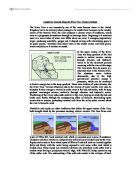
Waterfalls and V-shaped valleys on the upper course of the River Tees
Meanders and the mouth of the river tees on the lower course of the river Tees