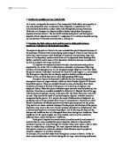
It is the process of hydraulic action that has the most erosional effect on the outside bend of a meander and after repeated erosion on the bank of the river channel, river cliffs form which in due time collapse. On the inside bend of a meander, deposition takes place and so slip-off slopes form. It is the repeated procedures of erosion and deposition that cause the meanders to migrate downstream, laterally eroding as they do so.
- Explain why there are large variations in the size, type and amount of load in rivers.
(10 marks)
The size, type and amount of load in a river are dependent upon many factors that affect a river and its load. The amount of discharge, the velocity, the course of the river and the rock type over which the river is flowing all affect the conditions of a river’s load. Although a river has various ways of using up surplus energy, such as meandering in the middle course of the river due to the gentler gradient, some of a river’s energy is used in transporting the eroded material downstream, and can be transported in one of four ways.
In the three courses of a river, there are perceptible differences between the size, type and amount of the river’s load as the river, this being due to the distinct erosional processes that take place in different courses of the river. In the upper course of the river, vertical erosion takes place due to the steep gradient and so the water cuts in a downward direction. As the river is keen to reach sea level as quickly as possible, it uses its energy on eroding vertically and so the river channel itself is quite shallow as well as being narrow. As a result of the water cutting vertically through the rock, large boulders are often left strewn in the middle of the river channel.
In the middle course of the river, lateral erosion takes over and the main erosional process at this point is the hydraulic power of the water. Hydraulic action is the force of the water on the river channel and the resulting frictional drag of the water on the particles of rock lying on the riverbed. Hydraulic action is extremely efficient and where lateral erosion takes place, erodes sideways and creates meanders, on the outside bend it has the ability to undercut the bank leaving a river cliff. In the middle course, the processes of transport are traction and saltation, where varying sizes of load are moved gradually downstream, dependent on the velocity and discharge.
As a river reaches its lower course, the river basin increases in complexity. A larger amount of load is available as you go downstream. This is due to the erosional process of attrition, where by the size of the material is reduce by the rocks and pebbles banging into one another and chipping pieces off. Over time, the particles reduce in size, becoming smoother and rounder and eventually turn into much smaller particles. The load is therefore increased in size as it is broken down and effectively has a larger surface area. It is in the lower course of the river that most of the load is carried in the form of suspension, where finer material is carried along in the flow of the water. The suspended load is often makes up the a large proportion of the total load and due to it’s overall large quantity, often causes the water to look murky or brown in colour.
The amount of load that a river can transport is dependent upon many factors. These include the discharge, as the greater the amount of water, the more load that it can carry, as well as the velocity, as a fast flowing river has more energy to transport a load as well as being capable of moving larger particles. The local rock types, over which the river is flowing, also have an influence, as softer rocks such as shale, are more easily eroded than other rocks, such as granite. The ability to transport is also dependent on the material available, in terms of the amount and location available. The character of the material also influences the amount that can be carried, as finer particles such as silt and clay will be transported further in the state of suspension, than boulders or gravel. The Hjulstrom graph is model that shows different velocities are needed to erode, transport and deposit different types of material.
The rock type of the land over which the water is flowing also has a lot to do with the size, type and amount of bed load found in a river channel along its course. Acidic water in the river channel has the ability to erode softer rocks such as Limestone and Chalk as the minerals in the rock are dissolved by the acidic components of the water. When the water is capable of eroding in this way, the minerals of the rock are carried by suspension and are moved along in the flow of water in a dissolved state. However, if the rock that the river is flowing over is of a much harder property, such as Granite, then corrasion will erode such rock and the transporting process of traction moves the larger rocks and boulders of Granite along the river bed. In certain circumstances, the larger of the boulders will only be capable of being moved in times of flood due to their size and the fact that a specific velocity is needed to transport them.
Similarly, the factors of discharge and velocity play an important part in shaping the size, type and amount of load that a river carries. Discharge is the volume or flow of the water within the river channel, passing a particular point in the river at a specific time. Discharge therefore has an influence on the load that is carried by the river, as the greater the discharge, the larger the river’s capacity to carry load. The velocity is the speed of the water’s flow in the river channel and so has an effect on the load that the river can carry as the higher the velocity, the higher the amount of energy that the river potentially has to erode and transport. Discharge and velocity both increase in a downstream direction. The discharge increases because the size of the river channel increases as the river flows downstream, allowing a larger volume of water to fill the channel. As the channel increases in both width and depth in the middle and lower courses so does the velocity, which is due to the increase in the amount of discharge in the channel not touching the banks or bed, therefore lessening the overall amount of friction. A river’s capacity increases downstream and also in extreme events such as floods.
Human activity is an influential factor on rivers and the load that they carry. For example, the River Tees runs through an industrial area in its middle and lower courses. As a result, the pollution from the industrial sites is discharged into the rivers and affects the load in that a high amount of chemical load affects how much load can be dissolved and therefore transported in suspension. River management also affects the amount of load, such as the building of a dam. A dam may alter the state of a load as it could restrict the load from being carried downstream.
- Explain where and why depositional landforms occur along the course of a river.
(10 marks)
There are several main depositional features that are formed along the course of a river. The occurrences of these depositional landforms are due to particular influences upon a river, such as the velocity, the amount of amount of load and the weight of the load. Although depositional features are only found in the middle and lower courses, certain landforms are specific to the different courses of the river. For example, slip-off slopes would be recognised in the middle course of a river, whilst features such as deltas, eyots, levées and wide floodplains are typical to the lower course.
In the middle course of the river, the river erodes laterally because of the surplus energy is has and so forms meanders. The strongest current in the water generally hits the outside bend of the meander, continually eroding and undercutting the riverbank, leaving a river cliff that will eventually collapse into the channel. However, on the inside of the meander, the water’s velocity is much slower by comparison and it is here that the river tends to deposit its load. The load builds up over time and the result is gentle slip-off slopes.
In the lower course of the river, depositional landforms are much more common due to the greater amount of discharge, and therefore larger amount of load that has been transported to the this course of the river. As the river nears the sea, the floodplain, the proportionately flat expanse of land on either side of the channel are developed, forming a valley floor. A floodplain’s width is determined by the rate of meander migration along with the level of lateral erosion taking place, because as the river erodes laterally, the meanders migrating downstream, the valley floor itself widens. The floodplain is made up of alluvium due to frequent flooding of the lower course, however, other much courser sands and fine gravel also help to make up the composition of a floodplain due to point bar deposits and meander scars that are combined with the floodplain. In times of flood, the water’s velocity decreases as it flows over the banks, allowing for deposition to take place, adding further grains of rock and clay to the floodplain’s alluvium. Frequently flooding rivers that have a substantial load will build up a thick level of alluvium on the surrounding floodplain, such as the Ganges Valley in Bangladesh.
The process of repeated flooding also allows for levées to form in the lower course of the river on the riverbanks. Levées are high banks of silt near the river channel itself and are recognised as natural embankments. Levées are most common along the banks of rivers that carry a considerable sand and silt based load, that flood frequently. During times of flood, when the river channel overflows, the friction between the overflowing water itself and the floodplain is increased. The water left on the valley floor and riverbanks is of a low velocity and so the result is deposition of the load carried by that water. The heaviest, most coarse material of the load is deposited first, nearest to the river channel, helping to build up the embankments. When the river is at low flow, it is likely that the river will also deposit in the form of building up the riverbed, which not only raises the river but also in certain circumstances, may cause the level of the water to be above that of the floodplain.
In some situations, in order to act as defence to flooding, levées have been artificially raised, an example being the Mississippi. As the river deposits some of its load on the actual riverbed, the level of the bed raises and so the level of the water increases, sometimes flowing above the level of the floodplain. This has disastrous consequences as when the river needs to flood naturally, pressure is put on the artificial levées. Over time, the levées will eventually give way and cause much more damage than if the river had been allowed to flood naturally in the first place. A way to prevent this is by dredging the riverbed to lower the level of the water and so reduce the pressure put on the embankments.
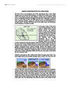
Deltas are expanses of land that form in the mouth of a river, formed by deposition by the river. Deltas are generally flat and are crossed by small streams known as distributaries that are fringed by levées. Lagoons form on deltas when levées join with the help of spits and bars, sealing off shallow areas of water. These lagoons eventually turn into marshes which over time dry up and become vegetative land. Certain conditions are necessary of a river for a delta to form in its mouth. Firstly, the river must have an ample load and secondly, the rate of deposition must be greater than it is removed by the tide of the water. Deltas generally occur in calm, tideless seas such as where the Rhône enters the Mediterranean Sea. The periodic flooding of the river, which deposits further amounts of alluvium helping to build up levées, helps the formation of a delta. Finally, the process of flocculation, where river water meets the salt of the sea water has an electrical charge which causes molecules to stick to one another, increasing their mass and so causing them to deposit on the riverbed, helps to form the depositional feature known as a delta. There are two main types of deltas, and their shapes distinguish them. One known as a ‘bird foot’s delta, such as the Mississippi delta and the other is recognised as an ‘arcuate’ delta such as the Nile delta.
A braided stream is a stream that has islands of build up deposited load within the river channel, known as eyots. Braiding tends to take place in streams where the load is made up of much heavier, coarser material such as sands and gravel’s. The channel itself is generally straight in this course of the river, however, the eyots and smaller channels within this one river channel go through many changes in both shape, size and position.
A characteristic of streams and rivers that have a varying discharge is the process of braiding and they tend to be very common in semi-arid areas or glacial-fed streams. Streams with high velocities and heavy loads are resultant of torrential downpours of rain, causing substantial overland flow, are typical of semi-arid areas. Evaporation and infiltration following the storm, lessening both the volume and velocity of the stream, cause the deposition of the load. Glacier-fed rivers have increased discharge due to the ice melting during hours of sunlight, however, at night and during winter, the discharge is noticeably less. During times of high flow, the river is capable of carrying and transporting a large load, though, when a stream’s competence and capacity falls due to the decrease in velocity, the result is the load’s deposition and over time, the formation of eyots.