In MEDCs, beyond the central business district is the manufacturing zone, complete with high density, low quality terraced houses to accommodate the workforce. Factory owners built these houses close to their factories, despite the high land costs, but they were small consequently. These houses were later occupied by working class people due to their need to be close to their employment in the CBD because they could not afford the high price of transport. However, one aspect of invasion and succession that Burgess did not take into consideration is the process of gentrification. Middle class workers later moved back into and invested money into the low quality houses, so they had high quality housing near to the CBD.
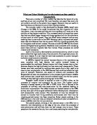
Burgess’s model cannot be applied to cities in LEDCs either, as the processes of invasion and succession do not occur. The highest quality housing is located nearest to the CBD in LEDC cities. This is because of the processes of self-help and auto-construction by the residents leading to continuous improvement. The oldest houses are located nearest to the CBD, as they were part of the original settlement before development, urbanisation and consequently urban sprawl. This benefactor of time has allowed the owners to improve their living conditions continuously over their lives by investing earned money into these properties. Richer people working in the CBD also live in the inner cites, as transport networks are poor compared to in cities in MEDCs were the rich can commute.
The poorest people, working in the informal sector in the CBD, live in relatively new shantytowns on the edge of the city, where the processes of auto-construction and self-help have not had enough time to occur. These people are the newest to the city, from rural areas, searching for new jobs after mechanisation has left their jobs redundant. This movement of people at childbearing age from rural to urban areas has lead to urbanisation: an increased percentage of people living in urban areas.
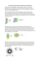
Hoyt (1939) emphasised the importance of transport routes. Sectors develop along important routeways from the CBD outwards, due to the increased transport amenities. In addition, certain land uses, for example, sectors of high-class residential and manufacturing industry areas deter other land uses, meaning adjacent sectors would have similar land prices. High status residential areas are located away from industry. Eastern sides of towns often developed as the industrial side of town. This was partly because of the prevailing wind conditions. In MEDCs, early industrialists located their factories in areas of cheap land, while wealthy people were concentrated to the west of town. Once started, these basic east-west divides were difficult to change.
Hoyt’s model suggests that all of these sectors radiate directly from the CBD. In reality however, this is not the case for all cities. Communication networks could encircle one outer side of the city. This would cause sectors of high quality housing in the case of boulevards, or industry in the case of rail or river networks to develop. Some cities, such as Milton Keynes, are planned. This means that the natural process of invasion and success put forward by Burgess could not be applied to this situation, as high quality housing could be situated near the CBD, and to estates of low-quality housing positioned in pockets within the suburbs. Sectors shown in Hoyt’s model would not develop either as the different land uses would be pre-decided by town planners, rather than being caused by transport links or prevailing winds.
Historical patterns of ownership in conjunction with Government ownership, such as army barracks, seen in Colchester, can also determine the pattern of urban land use. They both prevent the construction of a certain commercial, residential or industrial buildings that would develop otherwise, and directly affect the adjacent land ownership. Low quality residential rather than industrial or commercial buildings would be seen next to army barracks for example, as wealthier people would rather live away from barbed-wire perimeters.
Physical factors, such as rivers providing good transport links, required for the development of industry, can also affect the urban land use patterns, limiting the applicability of models to do not consider or allow for consideration of these factors.
We have seen the limitations associated with urban models, however all geographical models have inadequacies. This is because they serve to only to simplify, in the representation of, the complex geographical processes occurring in today’s world, in the hope to improve our understanding.
Burgess’ and Hoyt’s models can fall pray to being over-simplified representations of urban land use patterns. However, when they are combined with other models or cities similar to the one it was based on, Chicago for Burgess’, urban models can prove to be a valuable tool in the geographical assessment of urban land use in MEDCs and LEDCs.