
Effects of Climate Change on monsoon in Bangladesh
Climate Variability and Change in Bangladesh The global climate is changing and it is likely to change further over coming decades due to increasing concentrations of 'greenhouse gases' in the earth's atmosphere caused largely by human activities. This will result in greater variations in weather patterns, a greater frequency of extreme weather events such as floods, droughts and tropical storms, and gradual rises in average temperatures and sea-levels. Bangladesh is extremely vulnerable to climate change impacts because of its geographical location, high population density, high levels of poverty, and the reliance of many livelihoods on climate-sensitive sectors, particularly rural agriculture andfisheries. These impacts will be falling more heavily on the women and girls of Bangladesh. Climate change therefore threatens both previous achievements and future efforts to reduce poverty in Bangladesh to date, particularly by reducing water and food security and damage to essential infrastructure during more frequent disaster events. Bangladesh has always been vulnerable to climate variability. This is due to its geographical features and location, high influence of monsoon and regional flow patterns, too much water in monsoon and too little water in the dry season, etc. These have significant effects on the socio-economic realities, i.e. population density, inequity
Flooding In Bangladesh.
.FLOODING IN BANGLADESH. Bangladesh is in southern Asia, bordering the Bay of Bengal between India and Burma. Bangladesh is an extremely poor and a country that is prone to extreme devastating floods. The geography of Bangladesh does not help either. The population of Bangladesh is 131,269,860 and the total area of the country is 144 thousand square kilometres this works out to be a 900 people to a square kilometre. 82 percent of these people are distributed in rural areas and 18 percent of these people are distributed in urban areas. Bangladesh's terrain is mostly flat and slightly hilly in the southeast. The climate in Bangladesh is normally mild in the winter months (October to march) and hot and humid in the summer months (march to June) then in the months of June through October the climate is humid and warm with lots of rain, this is the time of the year that the monsoon takes place. The land in Bangladesh is used in 4 main ways. Arable 73%, permanent crops 2%, permanent pastures 5%, forests and woodlands 15% and the other 5% is in other ways. 31,000 square kilometres of Bangladesh is irrigated. Bangladesh is prone to many natural hazards such as; cyclones, draughts and of course floods. The floods in Bangladesh are due to a few main factors, which are coastal flooding, river flooding, tidal surges, deforestation, erosion and the monsoon. The annual rainfall in
Flooding in Bangladesh.
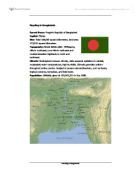
Flooding in Bangladesh. Formal Name: People's Republic of Bangladesh. Capital: Dhaka. Size: Total 144,000 square kilometres, land area 133,910 square kilometres. Topography: Broad deltaic plain. Chittagong Hills in southeast, Low Hills in northeast and modest-elevation highlands in north and northwest. Climate: Subtropical monsoon climate, wide seasonal variations in rainfall, moderately warm temperatures, high humidity. Climate generally uniform throughout entire country. Subject to severe natural disasters, such as floods, tropical cyclones, tornadoes, and tidal bores. Population: Officially given at 109,963,551 in July 1988. Bangladesh is trapped between two sets of floods: one caused by tidal surges and a rising sea level, and the other by rivers. > Silt, deposited at the mouth of the Ganges and Brahmaputra, has formed a large delta. This eventually created many flat islands. They attracted large numbers of farmers for rice growing. Further deposition of silt blocks the main channels and increases the flood risk by raising the beds of the rivers. Flooding is most likely to occur in late summer following the seasonal monsoon rains. > Water is pushed northwards by tropical cyclones up the Bay of Bengal. Silt deposits cause the Bay of Bengal to become narrower and the sea shallower. The water builds up to form a storm surge. The total height of the water can reach 8

The Bangladesh Floods
The Bangladesh Floods. Is Nature or Human Activity to blame? What can be done to prevent a repeat of the 1998 flood disaster in the future? Bangladesh is a small less economically developed country situated in Southern Asia. It is mostly surrounded by its neighbour India although it does share an Eastern border with Myanmar (Burma) and to the south it faces the Bay of Bengal. It is the world's largest delta with a total area of over 148 000 square kilometres which is just slightly smaller than England and Wales. Its population however is more than double that of the whole of the UK at over 126 million people. This makes Bangladesh's population density over 850 people per sq km. The main use of the land in Bangladesh is for farming with 75% being arable farmland producing mostly crops of rice and wheat. 5% of the land is pasture, while 15% is forest meaning that only 5% of Bangladesh is actually urban. This is because Bangladesh is a relatively young country gaining independence from Pakistan on 16th December 1971 making it only 32 years old. It has one main international airport at Dhaka although there are others around the country. E.g. in Sylhet. Bangladesh is generally very flat which is perfect for farming. It has one of the world's longest beaches at Cox Bazaar and the climate is very hot for most of the year. Bangladesh has 6 seasons every year. For most of the year
Flooding in Bangladesh
Geography Coursework Flooding in Bangladesh By ... Intro Bangladesh is located in southern Asia; India borders Bangladesh to the west and Myanmar (Burma) to the east. Nepal and Bhutan are north of Bangladesh. The Bay of Bengal is situated south of Bangladesh. Bangladesh is roughly the same size as the UK; however the population in Bangladesh is superior with 110m to the UK's 60m. Dharker is the capital and the most populated region of Bangladesh. The GNP of Bangladesh is only 180$ which is a staggering difference with the UK's, which is 20500$. Most of the terrain in Bangladesh is flat and low-lying, although there are still hills in the north-east that rise to 200m and hills in the south east that are 600m. The three main rivers in south Asia, the Ganges, the Meghma and the Brahmaputra have formed Bangladesh from depositing sediment; they all flow from the Himalayas in different countries and meet in Bangladesh, as they flow through Bangladesh they split up into a giant area of Delta. Bangladesh is one of the poorest countries in the world; a reason for this is because they mainly export ready made garments and primary goods like shrimp, leather and jute. Bangladesh has a tropical monsoon-type climate, with a hot and rainy summer and a dry winter. January is the coolest month with temperatures averaging near 26 deg C and April the warmest with temperatures from 33 to 36
Bangladesh Flooding
Introduction In this assessment I'm going to be writing about the flooding in Bangladesh. First I will look at the causes of flooding, including human and physical causes. I will also be writing about the effects of these floodings and how people cope with these disasters, including some pictures and images. In addition, I will include a short story about a lucky survivor as well as how human activity is making the flooding worse. Furthermore, I will be talking about the conflicting demands and what I think will happen in the future. Data UK Bangladesh Population (millions) 55 18 Area (sq km) 245000 44000 No. of people per sq km 241 909 Average annual income (£) 2000 50 % of people living in rural areas 0 82 Length of roads per 1000 sq km of land 500 30 Phone lines per 1000 people 488 2 Radios per 1000 people 429 47 TV's per 1000 people 488 2 Causes of Flooding (Human & Physical) There are lots of different of the Bangladesh flooding and they can be split into two sections; human causes and physical causes. Human causes are when humans do things to cause the flooding but a physical cause is what happens naturally to cause the flooding. Human Causes Cutting down trees causes increased run-off (water flowing over the surface of the earth).This is called Deforestation. Rain water reaches rivers faster which means flooding becomes more likely.
Geography Bangladesh Coursework
BANGLADESH COURSEWORK To what extent does the Physical Environment of Bangladesh determine its level of development? What efforts could be made to reduce the country's problems? The aim of this coursework is to investigate how Bangladesh's Physical environment is affecting the rate of the development of the country. Furthermore, to explore what efforts could be made to reduce the country's problems. [Section 1] To what extent does the Physical Environment of Bangladesh determine its level of development? Bangladesh is situated in South Asia. It is surrounded by India, and borders Burma. The population is roughly 150 million people; 45% of it's population is in poverty. The minority of the population of in Bangladesh are located in Dhaka, the capital city, Chittagong and Khulna; most of the population are located in rural areas. The main river running through Bangladesh is the Ganges-Brahmaputra. This river is the main cause of the issues in Bangladesh. Monsoons occur every year, without fail, causing the country even more problems. Only 40.1% of the adult population are literate, and only 21.6% of children have secondary education. The government are continually trying to solve the problems, but this is unsuccessful as a result of the country's poor wealth. Bangladesh is 49.8% below the poverty line referring to its wealth, and its rapid population growth hinders the

Bangladesh floods.
Bangladesh is an economically developing country in south East Asia (See map). The capital city of Bangladesh is Dhaka, which has a population of 8.5 million. Bangladesh has a dense population. Its population is 129 million. Its annual growth is 4%. Its inflation is 7%. Its major industries are Jute manufacturing, cotton textiles, food processing, steel, fertilizer's, rice, tea, wheat, sugarcane, potatoes, beef, milk and poultry. Its major trading Partners are Western Europe, US, Hong Kong, Japan, India, China and Singapore. It has an area of 143,998 sq km. Most of Bangladesh's population live on the floodplain and delta of the Ganges and Brahmaputra rivers. 50% of the land lay 15m below sea level. Bangladesh has a monsoon climate, therefore it receives between 1400-1480mm of rain per annum most of which falls between May and October. It has a beautiful land scope with a lot of history and a variety of attractions. It has the longest beach and the largest littoral mangrove forest in the world. Flooding is a common problem, which occurs annually and affects large areas of the country. In 1998 a flood lasted 65 days and destroyed crops, houses, roads and railways and left many people dead. Flooding may be a result of natural or human activities. In this article I will find out if the floods were from a result of natural or human causes and if anything can be done to prevent

Implementation of national adaptation programs of action in order to provide immediate and urgent support to start adapting to current and projected adverse effects of climate change in Bangladesh.
PROJECT TITLE: Implementation of national adaptation programs of action in order to provide immediate and urgent support to start adapting to current and projected adverse effects of climate change in Bangladesh. ESTIMATED TOTAL BUDGET: US$ 250,000 ESTIMATED STARTING DATE: January 2008 DURATION: 18 months . Background of the Project: Bangladesh is a country situated on the northeastern side of South Asia bounded by India on the west and the north, by India and Myanmar on the east and by the Bay of Bengal on the South (see Map). Numerous rivers, small channels and backwaters intersect the country's plain lands. Much of the present plain was originally an estuary, which was filled up by the combined drainage system of the Ganges, Brahmaputra and Meghna rivers (total length of drainage channel is estimated at more than 200,000 kms). These rivers continuously enrich the alluvial soil of the plains with heavy silt deposits. Thus, the rivers are of utmost importance in developing the country's vast flat alluvial land and in directly and indirectly influencing the economic activities through their impact on agriculture. The country has a typical monsoon climate as the monsoon wind, to a large extent, determines the country's rainfall and temperature. There are 3 distinct seasons: winter (November to February), which is relatively cool, sunny and dry; summer (March to

US methods in Bangladesh
Introduction and background info Hosting a population of around 140 million people, Bangladesh is the most densely populated agricultural country in the world. Physically, it is a small, low-lying, riverine country which is situated in South-East Asia (it is 55,599 sq miles large). It borders the Bay of Bengal, between its neighbours Burma, in the in the South-East and India, in the North-East. Its terrain is mainly flat, with hills scattered sparsely in the South-East. Bangladesh is located in the world's largest flood plain and delta-the Gangetic Delta. This is made up by the confluence of the Ganges (Padma), Brahmaputra (Jamuna), and Meghna Rivers and their tributaries which empty into the Bay of Bengal for irrigation purposes as well. In addition, 90% of landmass less than 10 m above sea level, which makes the country very prone to flooding- in fact it's one of the most flood prone country's in the World. The climate of the country doesn't help Bangladesh's situation, infact it plays a major part in hindering it. The climate's typically tropical, hot, and humid in summer (March-June), cool, rainy monsoon (June-October), and cool and dry in the winter (October-March). Bangladesh has many regular occurrences of cyclones, storm surges, and therefore floods, due to the climatic conditions. Aside its flood prone geographical position, the other natural,


