
The characteristics of Bangladesh and the possible causes of flooding.
The characteristics of Bangladesh and the possible causes of flooding. Bangladesh is situated between 22° and 27° North, either side of the tropic of cancer. It is bordered by India to the West, North and East, and by Myanmar to the South East. It is South of the Himalayas and North of the Bay of Bengal. Bangladesh Is very flat (all less than 200m ASL [above sea level], with 15% of land being less than 15m ASL. There are two main rivers in Bangladesh, The River Ganges and The River Brahmaputra. There are 230 river and tributaries in Bangladesh in total, which all drain southwards. The quality of life in Bangladesh is low, as both the population density and the death rate are high, and both Life expectancy and adult literacy are low. The land in the Delta (towards the Bay of Bengal) is vastly used for arable crops, as it is so fertile and flat. Most people in Bangladesh earn their living through farming, so they have to grow lots of food. The silt in the delta was eroded by the surface runoff picking up soil from fields, and by abrasion of the riverbed. It is transported by the sea waves, and by longshore drift. The flooding in Bangladesh is due mainly to the low-lying, flat ground, which makes the water spread out easily. The drainage density is high, so there is lots of water to create a flood, and coastal cyclones can sweep across the low-lying coast.

Letter to the World Bank - What are the causes and effects of flooding in Bangladesh?
Cross unit task What are the causes and effects of flooding in Bangladesh? World bank, My name is Corrina I am writing to make you take notice of the horrific times Bangladesh has to face. At least once a year they suffer from a serious flood, which have awful effects. They have a huge amount of crops ruined, which means no food for the hungry young children and the adults. Having no food maybe bad but seven million homes are damaged or totally destroyed. So means people in Bangladesh are made homeless. One flood causes 2,379 deaths. So people loose loved ones. After reading this I hope you offer Bangladesh help. Bangladeshis is in Southeast Asia. Its latitude is between 20'34 and 26'39 and its longitude is between 88'00 and 92'41 east. It has a high population of 118.000.000 and an area of 144.000 sq km. This makes it one of the most densely populated countries in the world. It has a population density of 824 people per sq km. Bangladesh is boarded by India on the north, west, and east, Myarmer on the south-east, and the Bay of Bengal is to the south. The capital city is Dhaka, which is 1,400 km from India and roughly 600 km from Mandalay. The 3 main rivers are the Ganges, the Jamuna, and Bramaputra. The Brahmaputra being in the north the river Ganges being northeast and the river Jamuna being in the centre of them all. Land is located on the delta of the Padma River.
Describe and explain the physical and human causes of flooding and the possible solutions that may be undertaken to prevent flooding and to deal with it.
Flooding Essay. Describe and explain the physical and human causes of flooding and the possible solutions that may be undertaken to prevent flooding and to deal with it. There are many factors that contribute to the causes of flooding. These causes can either be human, (things that happen due to human life and civilisation) or physical, (things that happen naturally to cause flooding). Physical causes: The drainage basin is the area of which the river drains its water from. The boundaries are marked by the watershed. There are many different ways of which water can enter the river channel. Some ways are quicker that others. The quickest are examples like surface run-off. This happens when the rate of precipitation exceeds the rate of infiltration, so it flows over the top of the surface and into the river. The slowest ways for water to travel are groundwater flow. Precipitation has to infiltrate through the soil then pass horizontally through permeable rock and into the river. These can increase the risk of flooding as the water is getting to the river quicker. This will cause a mass excess of water to run into the river and flood its banks. Groundwater flow will stop water getting to the river channel quicker but it will eventually get there. Also if storage of water is held somewhere this can increase the risk of flooding. For example surface storage occurs when the
Bangladesh Flooding
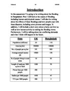
Introduction In this assessment I'm going to be writing about the flooding in Bangladesh. First I will look at the causes of flooding, including human and physical causes. I will also be writing about the effects of these floodings and how people cope with these disasters, including some pictures and images. In addition, I will include a short story about a lucky survivor as well as how human activity is making the flooding worse. Furthermore, I will be talking about the conflicting demands and what I think will happen in the future. Data UK Bangladesh Population (millions) 55 18 Area (sq km) 245000 44000 No. of people per sq km 241 909 Average annual income (£) 2000 50 % of people living in rural areas 0 82 Length of roads per 1000 sq km of land 500 30 Phone lines per 1000 people 488 2 Radios per 1000 people 429 47 TV's per 1000 people 488 2 Causes of Flooding (Human & Physical) There are lots of different of the Bangladesh flooding and they can be split into two sections; human causes and physical causes. Human causes are when humans do things to cause the flooding but a physical cause is what happens naturally to cause the flooding. Human Causes Cutting down trees causes increased run-off (water flowing over the surface of the earth).This is called Deforestation. Rain water reaches rivers faster which means flooding becomes more likely.

Flooding: Bangladesh
Flooding: Bangladesh Flooding is a major problem throughout the world, sometimes it costs many lives. In Less Economically Developed Countries (LEDCs) the effects of flooding can be disastrous, it can ruin people's lively-hood, their homes and their family. This is the reason why people must be protected from floods, the effects of them, and the causes of them eliminated. Bangladesh is a LEDC and suffers from severe floods regularly which results in many deaths and immense destruction on both, a geological and psychological level. The causes for these floods is Bangladesh's situation in the world, its sits on the confluence of three major rivers, two being the Ganges and the Brahmaputra. Bangladesh is also extremely flat, 80% of the country is flood-plain or delta. This, heavy monsoon rain and melting snow flowing down into the rivers of Bangladesh from India and Nepal, make flooding extremely likely. Adding to these physical causes are the human causes, such as highly densely populated areas around rivers, lack of education and funds as well as deforestation limiting interception and transpiration. As life is always valued the people of Bangladesh must be protected. There are many suggestions about what can be done to protect Bangladesh from it's unfortunate state. The biggest problem that Bangladesh has concerning flood protection is the funds that would be needed to
To what extent are the recent flooding problems in the UK a product of natural or human causes?
Flooding in the UK To what extent are the recent flooding problems in the UK a product of natural or human causes? Introduction A flood is an overflow or deluge of water that comes from a river or other bodies of water and causes or threatens or damages. "Floods are one of the most dramatic interactions between man and his environment, emphasising both the sheer force of natural events and mans inadequate efforts to control them. (Ward, R 1978)" Since the early 20th century we have seen flooding increasing through out the UK. In the last 10 years flooding has become more obvious and dangerous to populations around the UK. Flooding can be seen to have a number of causes, some natural in origin and some a result of human intervention, the question is how has flooding increased and what factors have caused it to do so. Natural effects A natural effect is a cycle or systems reacting to an input and giving feed back. This can be vegetation taking up more carbon dioxide and growing bigger to cope with CO2 emission or as in this case it is the rivers and seas releasing water to the land to deal with increased quantities of water at any given time. The main natural effect towards flooding is changes in climate mainly from precipitation. Looking at studies you would assume this was from increased precipitation but as shown in Figure 1 it is more likely that occurrences

Rainfall and Flooding
Rainfall and Flooding The flooding in York was due to the great amount of rainfall in the area, for example, in one year the average total rainfall for Folkestone is 740 millimetres but during the floods in York there was over 220 millimetres in just three weeks, that is almost a third of what Folkestone get in one year. The River Ouse rises in the Pennines and carries the Rainfall down the side of the mountains. When this reaches the foot of the mountain and the flat land, it overflows onto the flood plain. Because of the great amount of rain, the flooding spread to nearby cities such as York. Causes of Flooding, Aim 1: To investigate the causes of flooding in York. Hypothesis 1: York is situated in a place that is prone to flooding Causes of the floods: In York in the early months of 1982 there were severe floods. There are several explanations for the floods and as to what caused them and many people say that there should have been more done to have prevented them. However, they have past and a lot of the 2 million pounds damage has been rebuilt. All that the people in York can do now is to work at prevention methods to stop any flooding as bad as the last, in the future. The cause of the floods was mainly the great amount of rainfall which fell during the months around the time of flooding. In three weeks over 220 millimetres of rain fell. This is over one

The Boscastle Flooding
The Boscastle Flooding Heavy storms on Monday 16th August 2004 hit the area of Boscastle and Crackington Haven in North Cornwall, causing 6cm (2ins) of rain to fall in two hours in the Boscastle area, see the radar image below. Accentuated by the steep-sided topography surrounding the Boscastle area, such high rainfall falling in such a short time could not be absorbed into the ground and a 3-metre high flood rushed through the village (travelling up to 40mph) The flash flood at Boscastle, north Cornwall, on Monday 16 August, was the consequence of a violent four-hour downpour over the small catchment of the Valency river. There was no obvious culprit: some newspapers suggested that Hurricane Bonny was responsible, others blamed global warming, but in truth there was no evident external influence on the meteorological events of that afternoon In this essay, I will be investigating why the Boscastle flood occurred (including the effects and responses) and how we can limit the damage that flooding causes. In this essay I will also be investigating alternative ways to carry on with everyday life and still be able to keep the rivers from flooding. IMAGES OF THE BOSCASTLE FLOODING What were the causes, effects the response of the Boscastle flood? Rivers flood because of many reasons. Some reasons are deforestation. This causes flooding because the trees and plants cannot

Flooding in Yorkshire.
Page No: Title Introduction 2 Flooded Areas 3 Map of Yorkshire 4 Causes of flooding 5 Effects of flooding 6 Management of flooding 7 Conclusion In the past few weeks the whole of the United Kingdom has been hit by floods. The worst part hit was Yorkshire. Yorkshire is a big county in the North East of the United Kingdom. Yorkshire has been split up into four small county's which are : North Yorkshire South Yorkshire West Yorkshire East Yorkshire Yorkshire has some big cities like Leeds,York and Hull. York has been hit the worst by the floods. They have put flood defences in York and the river water is going to Barbly near Haywood. On the river Ouse in York there are 15,000 sandbags have been put on the river banks involing the emergency service,army and the local people. Much of York remains underwater after a week of rain. There will be three sections to explain about the floods : Causes of the floods The effects of the floods The mangament of the floods. Page 1 There are two types of effects of flooding in the Year 2000. They are: Immediate effects Long term effects Immediate effects Insurance Company has to pay millions of pounds to the damaged and flooded properties. The floods have hit businesses very hard. They have lost millions of pound in a few days. Some small shops have gone bankrupt. Years of hard work for some shopkeepers have gone down
Flooding in Bangladesh
Geography Coursework Flooding in Bangladesh By ... Intro Bangladesh is located in southern Asia; India borders Bangladesh to the west and Myanmar (Burma) to the east. Nepal and Bhutan are north of Bangladesh. The Bay of Bengal is situated south of Bangladesh. Bangladesh is roughly the same size as the UK; however the population in Bangladesh is superior with 110m to the UK's 60m. Dharker is the capital and the most populated region of Bangladesh. The GNP of Bangladesh is only 180$ which is a staggering difference with the UK's, which is 20500$. Most of the terrain in Bangladesh is flat and low-lying, although there are still hills in the north-east that rise to 200m and hills in the south east that are 600m. The three main rivers in south Asia, the Ganges, the Meghma and the Brahmaputra have formed Bangladesh from depositing sediment; they all flow from the Himalayas in different countries and meet in Bangladesh, as they flow through Bangladesh they split up into a giant area of Delta. Bangladesh is one of the poorest countries in the world; a reason for this is because they mainly export ready made garments and primary goods like shrimp, leather and jute. Bangladesh has a tropical monsoon-type climate, with a hot and rainy summer and a dry winter. January is the coolest month with temperatures averaging near 26 deg C and April the warmest with temperatures from 33 to 36


