'Evaluate how the Box Hill area is influenced by human activity'.
The title for this piece of coursework is 'Evaluate how the Box Hill area is influenced by human activity'.
The 'influence by human activity' reflects the way that humans utilise the Box Hill area and the effect that leisure and tourism have on the surrounding environment.
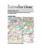
Location Map:
Box Hill is located in Dorking, Surrey, England.
OS map showing route and reference points
Scarp slope path:
Dip slope path:
_________________________________________________________________
. 225 MY : Weathering and erosion of very old folded rocks on an area of land.
_________________________________________________________________
2. 175 MY : Continued weathering and erosion on land in the north; deposition of weathered rock in the sea covering the area to the south.
________________________________________________________________
3. 120 MY : Continued erosion of the land as it is slowly uplifted and deposition in the sea as the basin gradually deepens. The size of the weathered rock fragments has varied- clay or sand at different times.
_________________________________________________________________
4. 50 MY: Deposition over the whole of this area, which has become submerged under water- including the deposition of chalk.
_________________________________________________________________
5. 25 MY: Alpine earth movements (Orogeny). The movement of the earth 's crust, which formed the Alps, also folded these rocks (but much more gently) and exposed them as land.
_________________________________________________________________
<Chilterns> <London Basin> <North Downs> <South Downs>
Vale of Holmsdale. Leith Hill. Low Weald. High Weald.
6. Present : Continuing weathering and erosion of the rocks since the folding and uplift. The clay (which forms valleys and low ground) has been eroded more than the sandstone and chalk, which form hills.
The importance of Chalk to the Box Hill area:
Over many hundreds of years, there has been a constant build up of rocks in the south-east of England, including,
> Clay,
> Sandstone,
> Weald Clay,
> L.R. Greensand,
> Gault clay,
> Chalk, and
> London Clay.
However, due to synclines, anticlines and present weathering, these layers of deposited rocks have been eroded and exposed, forming hills.
Box Hill is an area which lies on a layer of exposed chalk, meaning that the importance of chalk here is essential.
755:
We have chosen to study grid square 1755, as it contains Box Hill Country Park and its surrounding area. It is a popular area, which is frequently visited and can be easily accessed by the A24 and by the local train line. The peak of Box Hill, also indicated in the grid square, is a place where people come to see the incredible views of the downs.
Another reason why we chose this particular grid square was because of all the possible tests that we would be able to do, and all of the things there are to measure.
What we decided to measure:
> Primary Data:
Test
Reason
Noise pollution
We have chosen to measure noise pollution because of the vast amount of noise that emerges from the A24.
Traffic survey
We have chosen to measure traffic due to the A24 being visible from the mid-point of Box Hill, thus making the number of vehicles easy to measure.
Footpath Erosion
We have chosen to measure footpath erosion, as there is a long footpath in the area, travelling from the bottom of Box Hill, to the top of Box Hill.
Bi-Polar Landscape assessment.
We have chosen to assess the landscape because of the fantastic view which is visible from the top of Box Hill.
> Secondary data:
Test
Sources/information:
Accessibility
OS maps
Management
-Websites (www.nationaltrust.org.uk/learninganddiscovery)
- leaflets
- Textbooks.
The aims of my investigation are to study the Box Hill area in order to answer the following questions:
> What happens to the levels of noise as we travel further up Box Hill?
> What is the volume of traffic on the A24?
> What effect does trampling have on the main footpath?
> What is the landscape like at the top of Box Hill?
> How accessible is the area?
> How is the area managed?
Noise Pollution:
Method:
Using the sound level indicator, we recorded the average noise level on a chart, and also took down the highest and lowest reading for each location. Three readings were taken:
. At the bottom of Box Hill by the A24;
2. Halfway up Box Hill;
3. At the top of Box Hill.
Type of data:
Primary Data
Effectiveness
This technique was quite effective, as it was simple and easy to follow.
Problems:
Other noises, such as the wind blowing may have affected the results and made the reading higher than it actually was.
Limitations:
Everyone has to be silent, as any other noises that are picked up will affect the results.
Traffic Survey:
Method:
For a period of 10 minutes we recorded, onto a chart, all of the vehicles passing Ryka's Diner on the A24 and then worked out estimates for the amount of traffic per hour and per day.
Type of data:
Primary Data
Effectiveness:
The method was quite effective as we had a good view of the A24 from the mid-point of Box Hill, and we could see the numbers of vehicles that passed us. However, getting the results were difficult.
Problems:
Cars we going too fast, and were therefore difficult to count.
Limitations:
Because the A24 is such a big road, we could only count vehicles going on one side of the road at any time. This meant that we had to exchange results with someone who was measuring the traffic on the opposite side of the road.
Also, our traffic survey was done in the afternoon. More surveys were needed to be conducted in order to achieve a more accurate outlook of traffic that passes Box Hill per day. E.g. there would be more traffic travelling on the A24 at 7:00am than perhaps 1:00pm.
Footpath Erosion:
Method:
In small groups, using quadrats, a ruler and tape, we recorded the vegetation types, vegetation cover, vegetation height and footpath depth on each side of the footpath in 7 locations. This was done in 5 positions, from the beginning of the footpath to the top of Box Hill.
Type of data:
Primary Data
Effectiveness:
Quadrats only give you a % vegetation result for a certain part of the footpath; therefore, it does not give you an accurate result for the footpath as a whole meaning that the method was not that effective.
Problems:
This test took too long to complete.
Limitations:
Because there were so many positions that needed testing, we had to split up in small groups. This meant that we had to exchange results with one another, and other people's results may not have been as accurate.
Bi-Polar Landscape assessment:
Method:
We must complete the Bi- Polar landscape analysis sheet by carefully observing the landscape off and around the viewpoint at Box Hill. We must then put numbers in the suitable boxes in the table depending on our views. Our results as ...
This is a preview of the whole essay
Problems:
This test took too long to complete.
Limitations:
Because there were so many positions that needed testing, we had to split up in small groups. This meant that we had to exchange results with one another, and other people's results may not have been as accurate.
Bi-Polar Landscape assessment:
Method:
We must complete the Bi- Polar landscape analysis sheet by carefully observing the landscape off and around the viewpoint at Box Hill. We must then put numbers in the suitable boxes in the table depending on our views. Our results as a whole year group will then be combined, calculating an average score for each factor. A combined average total score for Box Hill can then be calculated.
Type of data:
Primary data.
Effectiveness:
I didn't think that this test was effective, because all of our results are based on opinions. Because many people have different opinions, results may not be accurate.
Problems:
Many people have different opinions. This could affect our year group results.
Limitations:
We only had a certain time limit at the top of Box Hill. This made it hard for us to gather our opinions about the view carefully.
Accessibility of Box Hill:
Method:
Using an OS map, we tried to answer the question, 'Are people attracted to Box Hill because it is easily accessible?'
To do this, we will...
. Measure the distances from junction 8 and junction 9 of the M25 to the car park at the bottom of Box Hill with a mini trundle wheel or an elastic band.
2. Count the number of train stations within 2km of the peak of Box Hill and name them,
3. Count the number of roads within a 16km area around Box Hill.
We will record our results in a table.
Type of data:
Secondary data.
Effectiveness:
The techniques were effective, as OS maps give an exact scale, meaning that we could measure the exact numbers of roads, stations and distances easily.
Problems:
Because the maps that we used were laminated, the mini trundle wheels kept slipping, and wouldn't give an accurate distance of the road.
Limitations:
There were only enough maps for us to work in small groups.
The management of Box Hill:
Method:
Using Secondary sources of information, we found out about how the Box Hill area is managed in order to preserve it.
Type of data:
Secondary data
Effectiveness:
The method was not that effective, as we were using secondary sources of data, as opposed to finding out for ourselves.
Problems:
Information about the management of Box Hill was hard to come by.
Limitations:
Secondary data could have been data that was collected many years ago, and could be out of date now. This could have affected our findings.
These are the results that I collected from each of my tests while at Box Hill.
Noise pollution measurements:
Results Table:
Location
Sound Levels (decibels)
. By A24
Average - 71dB
Lowest - 67dB
Highest - 78 dB
2. Halfway above Box Hill
Average - 62 dB
Lowest - 57 dB
Highest - 67 dB
3. Top of Box Hill
Average - 50 dB
Lowest - 47 dB
Highest - 55 dB
Graph of data:
I have chosen this method of presentation, as it would enable us to see the results as 3 parallel lines on a graph. These lines would be able to give us the range (difference between the highest and lowest) of results that we recorded, as well as the average results.
Traffic survey:
Results table:
Type of vehicle
Traffic going right.
Traffic going left.
Total traffic.
Estimated traffic per hour.
Estimated traffic per day.
Car
IIII IIII IIII IIII IIII IIII IIII IIII IIII IIII IIII IIII IIII IIII IIII IIII III
IIII IIII IIII IIII IIII IIII IIII IIII IIII IIII IIII IIII IIII IIII IIII IIII
63
978
23,472
Taxi
II
2
2
288
Bus
0
0
0
Coach
0
0
0
Motorcycle
I
III
4
24
576
Bicycle
0
0
0
Van
IIII IIII IIII IIII IIII IIII
IIII IIII IIII IIII IIII III
58
348
8,352
Lorry
IIII IIII I
IIII IIII IIII IIII
31
86
4,464
Other
II
2
2
288
Graph of data:
I have chosen this as my method of presentation, as it is a simple way to show the total numbers of a specific vehicle passing on the A24, as well as showing the different totals going left and right.
Footpath trampling measurements:
Theory work:
There are many ways in which footpath erosion and trampling could occur. For example;...
. There are different soil and rock types: Some types of soil and rock types are weaker than others. This causes them to erode to a greater extent as time goes by. This means, that if you compare two types of soil (one strong, and one weak), which have had the same conditions and the same amounts of trampling; the weaker soil may have been affected more than the stronger soil.
2. The pressure of use: Some people and some species of animals are heavier than others. Some animals even have smaller feet than others, meaning that they leave a greater pressure on the ground, as their great weight is spread out along a smaller area. Bicycles have the same affect, since the weight of the person is spread out along the area of the small wheels.
3. Slope angles: When people and animals walk up hills and slopes, they use a greater effort to walk. This means that they leave a greater pressure on the soil.
4. Type of vegetation: Some types of plants resist trampling more than others. For example: Mat grass, bents and fescues resist trampling best.
5. Climate: Places with heavy rain, strong winds and frost will erode rock types. For example, an aquifer rock such as chalk will absorb a lot of water from the rain, but will expand and break if the water absorbed turns to ice. Also, strong winds could cause weaker rocks to chip.
6. Animals and wildlife: Some animals such as rabbits and badgers make burrows to live in. This damages the soil by making holes in the ground, which will later fill up with water and cause the soil to be washed away.
Effects of trampling:
) Minimal trampling/ undisturbed:
The soil and rocks absorb Rainwater easily. The roots from the vegetation bind the soil together and keeps the soil aerated.
Good vegetation cover.
Roots binding soil particles together.
2)
> Trampling compacts soil and reduces the infiltration rate.
> Water starts to run on the surface.
> Some vegetation types are very poor at withstanding trampling, therefore the vegetation dies.
> Roots binding the soil together wither and die.
> Bare soil exposed.
Soil compacts, reducing infiltration rate of rainfall.
Forms shallow gully.
Rainwater washes away soil.
Vegetation dies away.
Fewer roots so more soil lost.
3)
> Vegetation dies.
> Surface water washes particles of the soil away.
> Small gullies soon become enlarged = soil erosion.
> Underlying rocks exposed.
All vegetation on the path dies.
Underlying rocks exposed.
Gulley which forms acts as channel for water running off fells.
4)
> The path deepens and forms a little stream; nobody wants to walk there.
> Nobody wants to walk on the exposed rocks.
> People start to walk on the side of the gully.
> The erosion problem spreads as the process starts again.
People trample grass at the sides causing the path to widen more.
Gulley deepens.
Stream forms.
Results:
Position 1
West
Centre
East
Distance (from centre)
3.0m
2.0m
.0m
0m
.0m
2.0m
3.0m
Vegetation types (No)
0
8
7
6
5
8
1
% Vegetation cover. (quadrat)
95
96
92
85
86
98
00
Vegetation height (ruler)
3
2.5
2
.5
4
5
Footpath depth
0
0
0
0
0
0
0
Position 2
West
Centre
East
Distance (from centre)
3.0m
2.0m
.0m
0m
.0m
2.0m
3.0m
Vegetation types (No)
0
9
4
4
6
8
0
% Vegetation cover. (quadrat)
99
97
95
85
96
00
00
Vegetation height (ruler)
5
3
0.5
.4
.5
5
Footpath depth
0
0
0
0
0
0
0
Position 3
West
Centre
East
Distance (from centre)
3.0m
2.0m
.0m
0m
.0m
2.0m
3.0m
Vegetation types (No)
0
6
5
3
3
8
5
% Vegetation cover. (quadrat)
00
80
95
85
92
96
98
Vegetation height (ruler)
5
3
2
2
2
6
9
Footpath depth
0
2
3
0
Position 4
West
Centre
East
Distance (from centre)
3.0m
2.0m
.0m
0m
.0m
2.0m
3.0m
Vegetation types (No)
5
5
2
2
4
4
3
% Vegetation cover. (quadrat)
80
90
50
60
70
90
50
Vegetation height (ruler)
.5
.5
.5
.5
.5
0.5
Footpath depth
0
0.5
.55
3
0.5
2
Position 5
West
Centre
East
Distance (from centre)
3.0m
2.0m
.0m
0m
.0m
2.0m
3.0m
Vegetation types (No)
3
2
2
0
0
0
2
% Vegetation cover. (quadrat)
35
0
3
0
0
0
5
Vegetation height (ruler)
0.5
0
0
0
0.5
Footpath depth
0
3
3.5
4
3
4
I chose this method for presenting the footpath depth data as it allows you to see the data for each of the distances from the centre of the footpath for every location. This makes it easy for people to see all of the results clearly.
I have chosen this method of presentation as it enables me to see all of the results for the numbers of vegetation types easily for each position.
I have chosen this as my method of presenting the different vegetation heights at different distances from the centre as it is able to give us an accurate view of the different heights for all 5 positions.
The management of Box Hill.....
Since Victorian times, Box Hill has been a favourite leisure area for the people of London and the surrounding areas due to its views and local wildlife.
Since the arrival of the railway track in 1849, arriving to the area from London, the hill has seen hordes of cyclists, picnickers, hikers and motor sports enthusiasts using its site as a trialling ground.
The national trust was given the land in 1913 and has managed it since that time. They help to preserve the land and therefore help the wildlife that benefits from the chalk that is found here.
The following designations help to protect Box Hill against development or change of use:
> Designated a Country Park in 1971
> Site of Special Scientific Interest (SSSI) within the Mole Gap to Reigate escarpment
> Area of Outstanding Natural Beauty (AONB Surrey Hills)
> Special Area of Conservation (SAC) a European designation given to the Whites Cliff
> National Trust ownership since 1913
*The national trust provides many different special visitor facilities at the bottom of the Hill in and around Ryka's Café. For example, there is a designated area for coaches, cars and motorcycles to be parked, although there is a fee for leaving vehicles. Coming out of Ryka's café, there are many benches and picnic tables which help the public, as they provide a space for people to eat meals bought from the café, or brought from homes. Also, not far from the area, there is a telephone box, allowing people to call home and other important places. There are also many amenity areas such as a shop, toilet, etc next to the main car park.
*At the top of the hill there is a viewpoint, laid out with a map so that visitors know exactly what they are looking at. This is where visitors can come and sit to admire the view. Nearby, there is a national trust café, where people can come and buy hot drinks and food. There is also a tourist information centre, where people can come and ask, or get any information that they are unsure of. All of these places make the top of Box Hill very suitable for tourists.
*Because Surrey is one of England's most wooded counties, 19% of the woodland needs to be controlled in order to preserve the diversity of the semi-natural habitats which are a feature of Box Hill. Wood is no longer grown here as an economical crop, and the management of the site is concentrating on preserving the wood that is grown here.
*Box Hill's woodland is managed by cutting bushes in order to keep the place looking neat and tidy, and to stop them from covering other vegetation and thus preventing light from getting to them. Views are kept open so that people can view the beauty from the hill. Woodland is coppiced, meaning that trees are filled in rotation about every 12 to 15 years, and using the grown shoots from the felled tree. Small areas of hazel, ash and sweet chestnut are coppiced at Box Hill. Box Hill also encourages a diverse fauna including the Roe deer, squirrels, sparrow hawks, badgers, dormice, white admirals, purple hairstreaks, silver-washed fritillaries and speckled wood butterflies.
*Dead trees are left in place. This helps the ecosystem as Box Hill is a nationally important site for a variety of species which depend upon dead and decaying timbre. This also helps preserve a diverse fauna, as it helps different species of animals live.
*Sheep grazing is the traditional way of keeping the grass short on Box Hill. They are useful to Box Hill, as they prevent the re-growth of scrub. This is a benefit to plants, as it means that there are no more weeds that sometimes strangle and kill plants. Another benefit to plants is that the sheep provide nitrates in their faeces, which could be used as fertiliser.
*The SSSI and the AONB help to preserve the natural environment as they both give the land a title which should be respected. They also give specific rules that people have to follow when on the site, and any violation of these rules could result in a heavy fine.
Accessibility of Box Hill:
. Measure the distances from junction 9 of the M25 to the car park at the bottom of Box Hill:
From junction 8: 13km (about 8 miles)
From junction 9: 10km (about 6 miles)
2. Count the number of train stations with 2km of the peak of Box Hill. Name them:
There are 3 stations
> Deepdeen
> West Humble,
> Pixham.
3. Count the number of roads within a 16km area around Box Hill.
Type of road
Number
Points
Sub-total
A (red)
2
4
8
B (orange)
2
2
4
C (yellow)
7
7
Road accessibility total:
9
Noise Pollution measurements:
Description of results:
> All three sets of results (the lowest, highest and average decibel levels) form straight lines on the graph, meaning that there is a pattern between the different levels as you go further up Box Hill.
> The three lines all slope downwards, meaning that the decibel levels have decreased, the further away you travel from the A24. This shows that the experiment has been a success, and there are no anomalous results.
Conclusion:
> As you can tell from the graph, the average sound levels and the range of sound levels decreased as we climbed box hill. This is because as you climb Box Hill, you get further away from the A24.
> The noise emanating from the A24 is an issue for tourists visiting Box Hill because it makes their visit unpleasant, as it spoils the peacefulness.
> The noise levels can be reduced by reducing the speed limit on the A24, as slower moving cars make less noise.
Traffic survey:
Description of results:
> There are more than twice as many cars on the A24 than Vans, which are the second most frequent forms of transport that we saw. This tells us that there are very many cars travelling on the A24.
> Likewise, there are almost twice as many Vans on the A24 than Lorries, which are the third most frequent forms of transport we saw.
> Our results show that many forms of transport travel along the A24, but most of them in small numbers.
Conclusion:
> Cars are the most common vehicles on the A24. This is because there are so many families who have cars now, as it is one of the main sources of transportation.
> Bicycles, busses and coaches are the joint, least common forms of transportation on the A24.
> The estimated number of vehicles in total travelling down the A24 per hour is 1,560.
The estimated number of vehicles in total travelling down the A24 per day is 37,440.
> A particular busy period on the A24 could be during 08:00 - 10:00 and 16:00 - 19:00. This occurs because of the many people travelling to work in the morning and then coming back home again in the evening.
> A particular busy day on the A24 could be during a bank holiday, when many people come down to see the countryside on Box Hill Country Park.
> People riding more bicycles and more people using public transport such as busses or trains could reduce the levels of traffic using the A24. Also, people travelling in the same direction or to the same location could give each other lifts and use one car between many people.
> A problem that the traffic could cause is pollution to the atmosphere. This means that more acid rain will fall, causing rocks to erode. Also, more and more people could get asthma.
Footpath trampling:
Description of Results and Conclusion:
> Due to the footpath, the vegetation types have decreased where there is a lot of trampling (The top of Box Hill). Also, the number of vegetation types is less towards the centre of the footpath than at the west or the east of the footpath.
> Due to the footpath, the vegetation cover has generally been the same for locations 1, 2 and 3, but is considerably less for location 5. This is what you find if you add up all of the results for each of the locations.
> Looking at my pie chart for the combined % vegetation cover, you will see that there is more vegetation cover at position 1 (the bottom of Box Hill) than at position 5 (the top of Box Hill).
> If you add up all of the results for each of the distances from the centre you will find that they are almost all equally the same.
> Because there is more trampling at locations 4 and 5, you will find that the vegetation height is less here. Also, my graph indicates that more people trample in the middle of the footpath, as there is a lesser vegetation height here for most of the locations.
Suggested solutions for Box Hill.
Because Box Hill is not a not a national park, it does not have the funding to make very expensive solutions to the footpath erosion problem. However, they need a solution that would not make the countryside look out of place. Therefore, it needs to think very wisely about how to keep the problem under control.
Firstly the National Trust has to think about curing the problem.
> A good idea would be to reseed areas that are not too bad. This would give it a chance to re-grow, and does not cost too much money. However, this would not work with places that are affected greatly by the problem.
> Another good idea would be to sink stones or gravel into the soil. This has great advantages since it looks natural. A disadvantage of this would be that it does not stop water erosion and only stops the erosion made by trampling. Although a way of fixing this would be to place pipes and gutters on the side of the path to drain the water, this may look out of place and spoil the countryside.
> A very good idea would be to place GEOTEXTILES (little wire meshes) on top of the eroded path. This would stop boot trampling as it acts like a barrier. Eventually, the vegetation would be re-established if it is used with re-seeding. A problem with this method would be that it is very expensive.
> The solution to Box Hill's problem could be to lay stones onto the footpath area as this would not only stop people from trampling on the vegetation, but would look natural. As this option is cheap, this could be what the National Trust needs to do to solve the problem.
Next the national trust has to think about controlling and educating the people.
. The national trust could make 'Please keep off the grass' signs, and 'Please keep to the path' signs.
2. The national trust could repair the damage, and divert any people to a different route. ('Path closed, Use other route' signs)
3. The national trust could educate people by handing out flyers, giving tutorials and making videos so that they can cause minimum damage.
4. The national trust could publicise Box Hill less so that less people use the area.
The accessibility of Box Hill:
Conclusion:
> The road accessibility total for Box Hill was 19. This total was reached through 2 'A' roads, 2 'B' roads and 7 'C' roads. This shows that Box Hill Country Park can be reached quite easily by land vehicles of all types.
> As there are 3 nearby train stations, people who do not drive can also get to the area easily.
> People who live far away from the area can also get there easily, as the M25 goes 13kms from junction 8 to the car park at Box Hill, and also goes 10kms from junction 9 to Box Hill.
> Ealing Broadway has a road accessibility total of 52 (7 'A' roads, 4 'B' roads, and 16 'C' roads. This is over the total of Box Hill by a significant amount due to the amount of 'A' roads in the 16km area. However, considering that Ealing is a town in inner London, which is a densely populated area and Box Hill is in the suburbs of London (a sparsely populated area), Box Hill Country Park has a good accessibility total nevertheless.
Final Conclusion:
In this piece of coursework, I have been researching into how human activity has influenced the Box Hill area.
To do this, I have undertaken a series of tests and have researched into many factors of human activity at the site. These include...
> Noise pollution,
> Traffic,
> Footpath erosion,
> Landscape
> Accessibility, and
> Management.
These techniques that we used reveal a great deal about the data.
With the noise pollution test, we found out that the amount of noise decreases as you go further up Box Hill. This is because as you go further up Box Hill, you are travelling further away from the A24. However, although the noise pollution reading that we got from the top of Box Hill was lower than the bottom, it was still quite high. This reflects the popularity of the A24.
The traffic test revealed that the type of vehicle that travels most on the A24 is the car. This is because it is a vehicle that has become more and more popular, as most families now seem to own at least 1. This is because cars are a convenient and comfortable way of journeying. Vans and Lorries are also popular vehicles, as they are able to carry large amounts of cargo.
These two factors of human activity can be linked to each other, as one could say that the greater the amount of vehicles that are travelling on the A24, the more noise pollution that occurs. At the time that we did our survey, there were many fast moving cars. Because fast moving cars make more noise than slow moving cars, more noise pollution was produced.
The footpath erosion test showed that more erosion happens in the middle of the footpath, as this is the area of the footpath where most people walk. Also, more footpath erosion has occurred at the top of Box Hill than at the bottom. This is due to more people walking at the top of Box Hill, where two footpaths join to make 1.
Our Bi-polar landscape results shows us that Box Hill is a very desirable place to visit, as it is an area of outstanding natural beauty. This could be one of the reasons for Box Hill's vast popularity as many people go there to witness the incredible views from the top. When this is linked to footpath erosion, it shows that countless people go to the top of Box Hill, which could be the reason to why there is so much footpath erosion here.
Our results for accessibility show that Box Hill is an area that is fairly easy to get to, due to the amount of train stations and 'A', 'B' and 'C' roads within the 16km area. This could be another factor in Box Hill's popularity.
I also found out about how Box Hill is managed and what facilities there are for tourists. As there are many facilities, including a car park, restaurant, view point, shop, a toilet and picnic tables, this shows that there are many things for tourists to do at Box Hill Country Park. This could be another reason for the success and popularity of the area.
Overall, what I have found is that Humans greatly influence the Box Hill area. This is through noise, trampling, pollution (litter etc.) and traffic. Since Box Hill is a Honey pot site, it is an easily accessible and well managed area with plenty of facilities for tourists. Because of this, Box Hill has to deal with many problems that humans cause through good management.
An overall limitation to our study was that after months following our visit to Box Hill, some of the things that we did escaped out of memory when writing up our coursework. This could have been improved by more than 1 visit to Box Hill, as this would have familiarised us with the park once more.
Acknowledgements:
> I would like to thank my parents, for providing me with all the equipment that I need for this particular piece of coursework.
> My sister for helping me and giving me advice whenever I needed help.
> Mr Cuthbert, for providing me with all the knowledge that I have for me to able to do this piece of coursework.
> My friends for giving me support while I was doing this coursework.
Bibliography:
> Drayton Manor geography field trip pack.
> Formation of southeast England sheet.
> GCP GCSE Geography.
> Longman's study guides for Geography.
> The Rambler association website.
> www.Streetmap.co.uk.
> www.studentcentral.co.uk.
> www.nationaltrust.org.uk/learninganddiscovery