Analysis of The Maer at exmouth, coursework
Introduction - The Maer, Exmouth
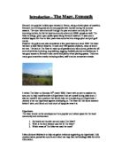
Exmouth is a popular holiday spot situated in Devon, along a lovely piece of coastline. Exmouth is a thriving area and is very popular with tourists during the summer seasons. The town host events all through the year and caters not only for the incoming tourists, but for its local community of around 35000 people as well. The Maer is a large, green open public space along Exmouth seafront. It was once a shallow lagoon but then in later years was converted into a large pitch and putt golf course.
However the golf course was demolished a few years back and since 1992 The Maer has been a local Nature Reserve. It hosts over 400 species of plants, many of which are rare. The land at The Maer is made up of grassland and sand-dunes, perfect for all sorts of activities including; dog walking, jogging, football, picnics and barbeques. It has good access to Exmouth town centre and plenty of car parking spaces. There are many good amenities nearby including toilets, café's and an amusement arcade.
I visited The Maer on Monday 16th march 2009. I went with an aim to explore the area, and to help myself answer a Hypothesis I had set myself during class work. I also set myself 3 key questions that would help me in answering my Hypothesis. I decided to set my hypothesis against developing on The Maer as I did some research before I went, and found out how much of a popular area it is.
Hypothesis:
The Maer should not be developed as it is a popular and valued space for the local community and environment.
. Do locals and tourists use and enjoy The Maer?
2. What is the land already used for at The Maer?
3. Which areas of The Maer are used the most?
I also did some fieldwork to help me gather evidence supporting my hypothesis. I did questionnaires, pedestrian counts and a land use map. See methodology table for extra information.
The Barbeque/ Picnic Area
In the middle of The Maer, there is a whole area designated to barbeques and picnics. There are plenty of litter bins nearby and also some toilets. It also has many built in barbeques for the summer months so that tourists don't have to bring one. This is strong evidence that during the summer months, The Maer is a popular barbeque spot for tourists and the community.
Housing and the Tennis Courts
The tennis courts at The Maer are used regularly by members and often hold many competitions. Developing on The Maer would destroy a popular amenity. Also developing on The Maer would affect the view of the beautiful Maer for the attractive houses opposite on the hill. The residents would not be at all happy and would more than likely protest.
The Land
As you can see from my photo, The Maer is a large, open stretch of land around the size of a large football pitch. The areas of sand show where the grass has been worn away due to humans walking on top of it.
Fieldwork
Method Used
Problems
Risks
Pedestrian count
Stood at two different locations for 10 minutes at each and tallied the number of people who walked past. I also noted down their approximate age and also what gender they were.
Not very popular time of year so there was not many people about. Also it was mid-week. (not summer) which is the popular time for tourists.
Missing people out of the count or counting the same people twice which would alter my final result
Questionnaire
Asked 3 various pedestrians visiting The Maer, the same questions with multiple choice answers and tallied the results.
Not masses of people to ask and also if someone's answer wasn't included in the multiple choice then it went down as 'other'. I didn't record what their actual answer was. It could have been useful to me in answering my hypothesis.
No real risks.
Litter counts
Stood at two different locations and tallied the amount of litter and what type it was in the radius of 5 metres.
The Maer is a very clean area so there was not much rubbish to report. Also the 5 metre radius was not a big enough area to get an accurate reading
Could easily have missed some litter.
Land-use map
I drew a brief bird's eye view map of The Maer and marked on all the different areas. I also took some photographs to help me with this task.
I couldn't see the whole of The Maer at once so it was hard to get things into perspective.
No real risks.
Primary fieldwork
...
This is a preview of the whole essay
The Maer is a very clean area so there was not much rubbish to report. Also the 5 metre radius was not a big enough area to get an accurate reading
Could easily have missed some litter.
Land-use map
I drew a brief bird's eye view map of The Maer and marked on all the different areas. I also took some photographs to help me with this task.
I couldn't see the whole of The Maer at once so it was hard to get things into perspective.
No real risks.
Primary fieldwork
Secondary fieldwork
Fieldwork
Method used
Problems
Risks
Questionnaire
Sheet given out-already completed.
Out of date and there is no information on the age of the people or what the weather was like.
No risks
Bi-polar analysis
Sheet already given out. I filled it out whilst I was there giving my opinion of The Maer.
It was only my opinion
No risks
Internet
I used the internet before I went to The Maer to do some research on the local area.
The internet is not very reliable. Do not know when the articles were written.
No risks.
Maps
I drew a base map of the land before I went out. I used this to draw the land uses onto.
No problems.
No risks.
Analysis
Fig.1- Google Earth Map of The Maer
The map from Google Earth shows the land at The Maer clearly. I have labelled on the different land uses, including the cricket pitch, tennis courts and barbeque area. It also shows the sandy paths that have been worn away by pedestrians using The Maer, as there are no foot paths as such. The car park and parking space along the front of The Maer are also either full or quite busy. This is all evidence that The Maer is well used by the public.
Fig.2- Pedestrian Count
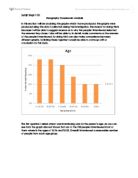
As you can see from my pedestrian count the majority of people visiting The Maer the day I visited were of an older age. The most frequent occurring age of both locations was 41-60 years old. There was no-one younger than 21 at The Maer. However there are some explanations for this. When I visited The Maer it was mid-week and midday, a time that the average employee would be at work or school. Also the weather was very windy and cold and every pedestrian I saw seem to be there only to walk their dogs. If we went back on a nicer day and more in the summer season we would have collected very different results. For my pedestrian count I tallied 20 people from location 1 whereas the secondary questionnaire asked 100 people. This shows that The Maer is very popular when the weather is nice and is a better time of year for tourists. The busiest area to count people for my pedestrian count was along the front of The Maer by the sand dunes where people were walking their dogs. Here I counted 32 people. The quietest area was the barbeque area where there was no-one. The residents of Exmouth and The Maer have no need for the barbeque area at this time of year.
Fig.3- Litter Count
My results from my litter count show that there was practically no litter at either location. It was a very clean area with lots of easy access to rubbish bins. Location 1 was right next to a bin so my results ended up being fairly biased. However there was more rubbish near the sand dunes because they were farther away from a bin. However I think that the main reason that there was not much litter was because of the lack of people. I think there would be a big increase in litter as the summer approached as there would be more tourists and residents using The Maer. As people begin to have picnics or barbeques I think litter will increase. The most type of rubbish around The Maer is bottles and food wrappers. This could be because people visit The Maer during their lunch break and may drop some of their rubbish.
Fig.4- Use of Maer- secondary questionnaire
Looking at my chart for how often people use The Maer, you can see that most people; (36%), use The Maer daily. People who use The Maer once a month are least frequent. 27% of people asked, said they used The Maer a few times a year. This was the second popular answer. I think it is because when the secondary questionnaire was carried out it was summer. 22% of people asked, were tourist so visited The Maer a few times a year for the holidays.
Fig.5- Activities at The Maer- secondary questionnaire
From my chart, you can see that the most popular activity at The Maer is dog walking. People can use The Maer for dog walking at any time of the year. The second most popular activity at The Maer is walking/jogging. The Maer is a lovely, open flat piece of land perfect for a quick jog or to get a bit of fresh air. People use The Maer least for barbeques. This is because the weather and season have to be just right to have one whereas you can walk your dog or go for a run in any conditions. 19% of people questioned used The Maer for football as it is a flat space in which no-one is being disturbed, so it is ideal.
You can gather information from both charts from the secondary fieldwork that say people use The Maer frequently and daily for dog walking.
Fig.6- Bi polar analysis
I completed the bi-polar analysis whilst I was at The Maer. Both locations had good access which is very important if a place is used frequently. Both locations had a wide appeal. For example the actual Maer can be used for dog walking, football; jogging and the car park could also be used for such things if it was not busy. The car park is very flat and certainly man made but also very large and practical for its purpose. The Maer is quite natural and hasn't been built upon. It is a nature reserve and hence it is multifunctional. The analysis is biased because it is only my opinion. The Maer may also look different if I carried out an analysis at a different time of year, for example if I carried it out in summer there would be more people and it wouldn't be quiet or even as attractive if there were too many people.
Q2. Management Features
Black netting
The black, plastic netting is placed on the cliff side to hold the marl in place, where the cliff is steepest. It is also disguised on beach to hold sand in place. Sand and marl cover the top of the netting, so therefore it does not look obvious or ugly. However the feature does not work very well. It is not secure enough, and the small grains of sand and marl are still washed away by the wind and tide.
Concrete Infill
The concrete infill is a concrete wall, set in place along the bottom of the cliff. It is set up to stop the steps, leading up the cliff, from collapsing because of the erosion. It blends in well with the cliff side and seems to be working as the steps are still in place and in one piece.
Sand Dunes
The sand dunes are basically big banks of sand that have been built up to stop sand and debris blowing onto the roads behind the beach. Some sand dunes have marram grass growing on top of them. The marram grass roots grow into the dunes and help hold the sand in place. Sand dunes with marram grass are working very well, however those without vegetation aren't working as well. Sand has blown off these from the beach and onto the roads.
This picture shows that one of the sand dunes hasn't worked as well and has let a lot of sand onto
the pavement behind.
Groynes
Groynes are set up all along the beach as a series of barriers, to stop the build up of sand from the direction of longshore drift. This can be either wind or the tide/waves.
In this photo you can see the change in height on one side of the groyne. You can see that one side is higher meaning that it has been slightly more built up on one side. The Groynes have worked in protecting the beach from the build up from wave movement. However they have not been as effective with longshore drift.
Sea Wall
The sea wall is in place along the back of the beach and is supposed to stop sand from blowing onto the roads and houses behind. It is a very deep wall and sloped along the top. However it has not worked very effectively.
This photo shows what the sea wall would have looked like before the sand had built up on it. The beach would have been approximately 5 ft below this wall when it was first built.
This photo shows sand on the road behind the wall which is evidence that it is not an effective management feature any longer.
Fencing
The black, plastic fencing is set up to start to build up a sand dune. The fencing does not stop sand from passing through it but it does slow the sand down, meaning it travels less distance. The fencing is working well and has been placed in front of the sea wall. The sea wall is therefore more exposed and more effective, because the sand dune is protecting it.
This picture shows the building up of sand around and behind the fencing.
Beach Nourishment
Beach nourishment is the name given to a beach management process. Tractors pick up sand that has blown from the beach onto nearby roads and pavements. They then dump the sand further along the beach. This is a very effective process and not only clears the rods for pedestrians and vehicles, but also, helps even out the distribution of sand along the beach.
Evaluation
Things that went well
I think my planning and organisation was fairly good. I managed to get all of my fieldwork that I needed drawn up before we went to The Maer so was relatively easy to carry out my investigation. The fieldwork was easy to do and I am pleased with my end results. I like the presentation I have used because it makes my results easy to understand.
What didn't go well
I think that the fact we visited The Maer out of season was a problem because when I wrote out my conclusion I had to think about how my results would have been if I had done my fieldwork at a more popular time of year. It made the investigation quite biased. Also it was hard to fit all of my results onto one sheet of paper. Another thing that didn't go well was my litter count. It was relevant to my hypothesis but it seemed slightly pointless because when I got there there was hardly any litter anywhere.
Things I would do differently
If I was to do this investigation again I would definitely visit The Maer again in season with tourists to get their views on The Maer. I would also do some fieldwork to show traffic and car parking. I think this would be more relevant to an investigation than a litter cot and it would probably be easier to construct. I would also lay my results out differently perhaps in a folder. However I am pleased with how my investigation turned out.
Conclusion
Do locals and tourists use The Maer?
The Maer is a very popular and valued space by the local community. It is used daily in all weather. It is perfect for all kinds of activities including football, jogging and dog walking, which is the most popular activity all year round. The Maer is popular for its sporting facilities such as tennis courts which are open to all members, and a large cricket pitch which is used regularly by the town's local side. If The Maer was developed on there would not be another suitable site to place these valued sporting amenities. Tourists also use and enjoy The Maer. It has a built in barbeque area which is very popular in the summer and would not be there if it was consequently not used. Exmouth is a prime and popular holiday destination in Devon. The Maer is exactly the sort of place people on family holidays need. They can play, have barbeques and picnics and even vistit the beach which is just a few meters away.
What is the land already used for at The Maer?
The Maer is already used for many different purposes and it is a very versatile land. It is flat in the middle but then is banked in by the sand dunes. Amenities include a barbeque area, tennis courts, cricket pitch, 3 car parks and a toilet block. The land is also used for activities such as football and jogging as it is quite flat. Picnics are also very common in the summer months as you can also fly kites amongst the sand dunes during the right weather. The Maer is also a nature reserve and on some occasions you may spot some rare wildlife and plants. It is a busy space, however the land does not look over-crowded or at all manmade.
Which areas of The Maer are used the most?
The cricket pitch and tennis courts are used by local residents and members all year round. Competitions and events are held at both locations regularly. In the summer months when the area is flooded with tourists the whole area of The Maer is used in general, from the barbeque area to the sand dunes. The car parks are full and the whole area is thriving. Even in the winter months and in bad weather, the open stretch of The Maer is still used for walking, jogging and dog walking. As you can see from my map, there are clear paths and footways that have been worn into the earth from the people using The Maer.
Hypothesis: The Maer should not be developed as it is a popular and valued space for the local community and environment.
All of the evidence I have collected goes towards supporting my hypothesis. The Maer is used daily by the local community for their day to day activities and is the centre of a very close community. The Maer is one of the only open, green spaces left in Exmouth and is the perfect environment that many people need in their day to day activities, i.e. dog walking or jogging. It is a safe area for children to play away from many busy roads and is also kept very clean by the local council and people. This shows that people both respect and value the area. Without The Maer a community loses its sporting amenities. Also many houses situated above The Maer would have their lovely views out to sea blocked by any building that was built onto The Maer.
Management Features for the Future
'Sustainable'
Sustainable means something that is continuous without damaging the environment or economy. Also something sustainable does not affect people in a bad way.
'The Future'
There are different options to choose for future management techniques at Exmouth:
. Do Nothing!
Let the natural processes happen, such as erosion and weathering etc until a new balance is achieved.
This is not a sustainable technique though and Exmouth would suffer extensive flooding and damage if the coast was left natural.
2. Maintain the Hard Defences.
Keep looking after and investing in the management features already in place. E.g. sea walls and groynes.
A very expensive option. Groynes cost £5000 each and only have a limited life. A sea wall also costs £10,000 per meter and would also need high maintenance. However they are very effective features and are working well at the moment.
2
3
4
5
6
7
8
9
0
Natural
Manmade
Quiet
Noisy
Uneven
Flat
Attractive
Ugly
Lots of wildlife
No wildlife
Poor access
Goodaccess
Lots of people
Few people
Multifunctional
Single use
Wide appeal
Narrow appeal
Litter count
Litter
Location1- Car Park
Location 2- Sand Dunes
Key
=Cigarette
= Bottle/ Can
= Food Packet
= Gum Wrapper
= Other