A similar but superior idea is to actually improve the existing defences by adding extra height to the flood defences down the river in order to reduce the flood risk. This plan is ideal for the regular visitors as the footpath wouldn’t be flooded by the rising sea levels, but may also come at a price. This idea is also quite a sustainable option, but this depends on the rate in which the sea level is rising each year.
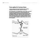
The final option has been taken into great consideration over the past few years and is now being carried out; it is called “The Cuckmere restoration project” and has been planned by the Environment Agency. The plan is a combination of the other three plans and involves a managed re-alignment. The long-term aims of the project are to:
- Re-connect the flow of the Cuckmere river through the meanders
- Re-create inter-tidal habitats like mudflats and salt marsh on the floodplain
- Increase the flow of water through the mouth of the river; and by doing so create a self-cleaning river mouth
- Remove the training walls/embankment walls from the mouth of the river
-
Fill in the straight cut that isolates the cut off meanders from the river.
The project was originally intended to start in 2003, but due to local objection, the start date of the scheme was delayed and the entire project is set to be completed by 2030.
The project is made up of two phases. In the first phase, the environment agency intends to breach the defences in the west. By doing so, more natural processes will resume; inter-tidal habitats will develop which could attract redshanks, ruffs and oystercatchers due to the change in wildlife. This phase will not affect the coastal landscape, but the river valley’s overall character will change as the types of ecosystems are altered. Fortunately, the biodiversity will increase due to active conservation practises. However, the breaching of the west defences will cause the public footpath to flood, facilities for fishing and some agricultural land to be lost.
Phase two intends to flood the eastern floodplain, reconnect the meander to the upstream channel and remove the defences from the river mouth. As a result of these actions, the natural river system will form a self-sustaining system, which will reduce the need for river maintenance, adding up to a saving of £30,000 a year. It will also lead to a great increase in the ecological status of the area south of the A259, especially inter-tidal habitats. The salt marshes created will provide valuable habitats where salt-tolerant plants can grow. Geese and ducks take advantage of the varieties of molluscs and crustaceans that live in the mud and silt that will be created. The salt marshes will be a very diverse habitat and play an important role in coastal flood defence as it dissipates the energy of strong sea waves that can potentially cause a lot of damage. However, some of the second phases’ consequences won’t be as beneficial; it will result in a loss of existing access to the beach to the east of the river once the river reverts to it’s original course next to the seven sisters, and although the scheme will assist salt marsh and mudflat habitats to develop and cultivate, there will be the removal of habitats for many creatures currently situated on the valley such as badgers and other woodland varieties. Moreover, the scheme will not only affect animals, but property, agricultural land and infrastructure will also be lost. The restoration projects plan will lead to the collapse of the sea wall, which protects the coastal cottages, endangering their future. Flood risk could be increased for villages such as Alfriston and Littlington, and even the main A259 road would be at greater risk, and also there will be years of mud before the salt marsh actually develops, leaving a vast area of unattractive mudflats.