We also measured the soil depth using a device called Auger; this enabled us to measure the deepness of the soil. We created a bar chart for the soil depth on each site in Coombe Hill. The graphs we made, allowed us to compare the sites for each different factor, e.g. Angle of Slope, Ph level and Soil Depth.
SITES IN COOMBE HILL
When we arrived at Coombe Hill, we walked through ten different sites, each of these sites differed geographically in terms of the angle of slope and soil type. In Fig 2, it shows our journey from where the coach dropped us off (A413) till the scarp slope after the monument. Site 1 was mainly flat land and used for transport purposes, Site 2 had fairly flat land which was used for farming, Site 3 was steeper therefore it was used for sheep grazing, also its vegetation was natural. Site 4 had a mix of both natural and human factors, there was a toilet built on this site.
Site 5 was Dunsmore Village, and it was a residential area, as there were houses built by the villagers. Site 6 was the woodland, where it was natural; Site 7 marked the end of the woodland and had a car park. Sites 8, 9 and 10 formed the chalk escarpment. Site 8 was the dip slope; Site 9 was the monument and Site 10 the steep scarp slope. In this coursework, I shall only be talking about the six main sites out of the ten; I shall be mentioning how the land use changes from site to site, and what factors cause the land use to change.
WHERE IS COOMBE HILL
The Chiltern Hills is located in South East England and stretches seventy-five mile southwest to northeast diagonal from Oxfordshire. It is located near Dunsmore, Aylesbury and Wendover. Coombe Hill is approximately 50 minutes away from London; the land around Coombe Hill is used for many different things such as woodland, farmland, residential, grazing and recreational use.
COOMBE HILL AREA MAP
Coombe hill is an example of a chalk escarpment in Buckinghamshire. The area around it is mainly grassland and woodland and is mainly owned by the National Trust. It is an AONB (Area of Outstanding Natural Beauty). This means that the area is preserved and maintained in its natural state. It is home to interesting wildlife species and different rock types- below a map shows you the type of rock use in the UK and more importantly in Wendover near Coombe hill.
GEOLOGICAL LAND USE MAP IN THE UK
WHAT IS A CHALK ESCARPMENT?
A chalk escarpment is a large ridge created by the erosion of dipping sedimentary rock. A chalk escarpment has one steep side and one gently sloping side. It separates two or more gently sloping surfaces. It is a common feature of chalk landscapes. Most commonly, an escarpment is a transition from one series of sedimentary rocks to another series of different age and composition. The chalk escarpment is also known as a cuesta. It consists of two parts – the scarp slope which is steep and the dip slope, on which the land falls away more gently.
The top of the escarpment has gently rolling hills with rounded summits. There is little surface drainage and the rivers are few and far between. Layers are tilted by the movement of the earth. The chalk escarpment is made up of sedimentary rock. There are two requirements needed for a chalk escarpment to form: One rock needs to be soft and the other needs to be more resistant to erosion. Also beds of rock dip at an angle to the ground surface. Instead of being horizontal, the beds are tilted by earth movements so that they lie at an angle to the surface.
MAPS
In this coursework, I will be producing two A3 maps. These two maps will show two different factors, which are vital for answering the three main questions. The 1st map will be a Land Use map, this is a very important map as it shows the different types of land uses around the Coombe Hill area e.g. Recreational Use, such as Golf Courses. Other uses for land could be Residential for building homes, or farming and grazing.
This map will also point out areas which are suitable for different land uses, such as houses would only be built on flat land, houses built on steep land would be difficult to build. Also, a golf course is also built on flat land, therefore making it a Recreational Land Use.
The 2nd A3 Map I will be producing is a Soil Type Map, which shows the different types of Soil in the Coombe Hill Area. In each of the sites, we went to the soil type differed. Some of the sites had clay, which is fertile, in the soil; this made the sites suitable for farming.
Chalk is a common rock in Coombe Hill, it is scattered all over the place, it is infertile, and therefore not many crops can be grown on sites with chalk. On the soil type map I will be outlining the route we took, with three different soil types in the map: Chalk, Clay and Chalk and Flint.
LAND USE MAP
ROCK
TYPE MAP
GRAPHS
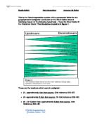
Along with maps, I will be producing three graphs which I will use to compare three different factors, the first graph I will be producing is Soil Depth, and this graph will show how deep the soil in each site is. Another graph I will be producing is the Angle of Slope; I will use a protractor to measure an angle for each site. The final graph will show the pH in each site, stating how acidic each site is.
These three graphs will help me make comparisons, and draw a conclusion for each site. The 1ST graph I produced was the soil depth graph, at site one the soil was the deepest, and at each site the soil got less deep and at sites 5 and 6 the soil depth was 20cm.
The 2nd graph I made was the pH Level in Soil graph; this graph showed how much acidity/alkaline there was in the soil. The results showed that the first 4 sites had a pH of 6.4 meaning there were slightly acidic. Site 5 was 6.9 nearly neutral and Site 6 was 6.8 again almost neutral. The final graph was the Angle of Slope graph, this showed the steepness of the slope on each site, and different sites had different angles.
SOIL DEPTH GRAPH
Ph LEVEL IN SOIL
ANGLE OF SLOPE GRAPH
Now I will conclude my coursework, by answering the three main questions using the research and information I have found out.
How do physical and natural factors help determine the land use of an escarpment?
Firstly, physical factors help determine the land use of an escarpment because features like soil and farming types describe how the land is being used. For instance, site three became steeper, meaning the angle of slope was the physical factor, and the land use changed from farming to grazing. Another factor that decides the land use is the soil type, if clay is present then it makes the land useful for farming, as clay is fertile.
Trees are another physical factor; the types of woodland contain trees that could be used for the industry. The mixed woodland provides a natural habitat for plants and animals. Slope Angle is also instrumental because the steepness of the land determines its use for example, houses can’t be built on steep land, and this is shown in Site 6, as there is no residential area on the scarp slope.
Another thing to mention is weathering and erosion. Weathering and erosion is vital because this is linked to all the other physical factors. A place where there is clay would be good for growing plants as it would change the nutrients in it, the acidity. Natural factors such as the natural vegetation are also important because the vegetation shows that if determines that this is the land use of an escarpment. The natural factors would be important because they just happen like randomly unlike physical which can be meant or not, also they can change the usage of the land for a very long time.
How do human factors help determine the land use of an escarpment?
Human factors help determine the land use of an escarpment, because they have a major effect on farming. Without humans, there would have been no houses, therefore there are positive and negative aspects caused by human factors.
Farming is a vital human factor. The land could be used for normal farming or arable farming. These human factors are very important because they establish that the land is being used for these things. The types of farming would affect the amount of land used because there needs to be a big area of land used up for farming. This helps determine the land use because a lot of things can be done with farming and it would take a long time to make the presence of farming known. This shows that because farming needs a big area and takes a long time to develop, it has determined the land usage of the escarpment.
One other human factor is the ownership of the land. In coombe hills case, a lot of it owned by the national trust which means they decide how it is used. This limits what can be done with it immensely so therefore affects the land use. It affects where people would live also as the national trust would not let houses be built on their areas. This factor is also very important because it outlines the fact the land will be used depending on what the national trust what it to be used for. So technically it could be used for anything. The land usage would not be linked to residential because there would be no areas where houses or flats could be built. Another reason of why it affects the land usage it’s because the national trust would not have changed the land but would have kept the land as it was.
And which factor I consider to be most important and why?
The most important factor I consider to be the most important is the soil type. I believe this because the different type of soil use used for different uses of land such as grazing and farming. This is the most important factor to me because it represents how the land was created and what type of plants and trees it has. I also think that soil is important because it outlines the fact that there is not the same soil everywhere.
In some sites, there was clay in the soil, which meant it was good for farming; this is a key factor as it highly determines the use of land, seeing as the crops would be fertile. The soil types differ throughout coombe hill and different rocks are resistant to erosion and have different uses.
The soil types determines the land use the most because the soil is considered to be the roots of the land, plants can grow if they are enough nutrients, this is an example of how the soil determines the land use, and this in my opinion is the most important factor.
EVALUATION
I’m going to evaluate the project, by stating what went well during the project, and what I could have done to improve. Things that went well were that I collect large amounts of information, such as collecting samples of soil, plants and any other vegetation. I used the samples in the project, as evidence to describe the sites. I also took photos of each sites, and the environment around them, this again was used as evidence and diagrams.
One thing we could have improved in this project is we could have visited another chalk escarpment around the UK. I thought this was essential as we could compare the chalk escarpment with Coombe Hill, to see whether the information was similar. It would have also made our results more accurate and precise, making it more reliable.
To conclude, overall I believe that I answered the three key questions, using all the information gathered. I gathered ample data to prove the hypothesis- The land use changes across an escarpment, this change is determined by both physical/natural and human factor. It also gave me an insight on what chalk escarpments are, how they are formed and what physical/human factors determine the land use of the escarpment.