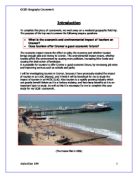
Management
The Following are ways of managing footpath erosion; all of witch are used by the LDNPA to control the effects of footpath erosion. The Photographs used below were taken by myself on cat bells, so we no that the LDNPA uses all these things at cat bells.
1) Pitching –Large stones are used to make steps, the slope must be over 15 degrees, it is labour intensive and expensive build
2) Aggregate –Small Particles of hard material usually local stone laid on the existing surface, the slope must be less than 15 degrees this is a lot less labour intensive than pitching therefore is much cheaper.
3) Culverts- Drains across the path help to stop water flowing down a path therefore minimising footpath erosion from water.
4) Zigzag paths –these reduce the gradient therefore less soil is eroded by water
5) Hand rails – Make the path obvious, and can block of areas for regeneration. These are generally a short-term measure as they are not durable
6) Stone Bordering- this makes the path more obvious and can minimise people walking off the track.
Key Terms
Aims
- To look at the Effects of tourism on The Lake District:
- To find out whether tourism has increased congestion
- To find out whether tourism has effected the land uses of the area
- To find out whether tourism has increased the pedestrian flow
- To find out the origin of tourism and how far most people have travelled to get there
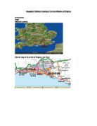
- To find The Sphere of influence of the area
- To rate the impact of tourism on the environment: Air pollution, Litter, Eye sores etc
- To find out Specific details from both tourist and residents to be able to come to conclusions
- To find the effects of tourism on footpath erosion.
- To see the effects causes and prevention techniques of footpath erosion.
Hypothesis
- The number of Pedestrians (majority who are tourists) will decrease with distance from the centre of the town.
- The town of Keswick will draw a large number of people in from a large number of areas therefore it will have a large sphere of influence
- The majority of the land use in Keswick will be touristic and residential.
- The large majority of people will be tourists and may have travelled a long distance, a majority would have driven, most will use services and the purpose of their visit will be a family holiday.
Sampling
Sampling is when you take a section of the population and survey them, in order to get an idea of what the result would be if the whole population was surveyed, there are two fair ways of doing this.
Systematic sampling
Systematic sampling is when you use a system involved in your sample for example you either this does ensure fairness however is not random and can be considered in some cases unfair. It involves first considering the right system to use for example on a car tax disk survey you could use the system of checking every other car or every fifth car.
Random Sampling
Random sampling is the process of generating random numbers either from a random number table or generating random numbers on a calculator. This avoids unfairness or bias. These numbers can be used to locate random map locations by drawing grid overlay and numbering each grid, you then make sure these numbers can be randomly generated, from these you can then locate several points on a map which can be used for pedestrian counts and traffic counts. It can also be used for choosing people to survey by for example generating a random number and waiting for that amount of people or seconds to pass then asking the next person to fill out the survey. This is my preferred method because it is far more random and shows a greater representation of the overall population.
Methodology
Traffic Count
A traffic count was conducted on the 9th of May 2007 at 10:30AM. This was carried out in order to get an idea of the traffic flow in different points in Keswick. Firstly we split Keswick up into 8 sections which we would sample separately, on each area we drew grid a overlay and numbered the grid with certain numbers which we ensured were in the range of our random number generator on our calculator (for more information see sampling section above) we randomly generated three points. Then we went to each of these points separately and stood on the edge of the pavement and counted on a tally chart the amount of cars passing an imaginary line in front of us. I continued doing this for five minutes. We used five minutes as a time to let even the least populous area have enough time to let at least a few cars pass, but yet on a fast road it won’t become difficult.
The Limitations were that when we carried out our traffic counts it was a rainy day this means that many more people may have been driving than usual. Another limitation is the possibility of human error in counting especially on busy roads where it becomes difficult to keep up. Another limitation is that the time we did the survey may not show a fair representation of the normal movement of traffic due to different times of day for example commuters in and out and shopping, if we wanted to be more accurate we should do the traffic count at three different times on three different days and calculate averages in order to get a more accurate result.
Pedestrian Count
A Pedestrian count was conducted on 9th of May 2007 at 1:30PM. This was carried out in order to get an idea of the areas that have large amounts of pedestrians and notice any occurring patterns. Firstly we split Keswick up into 8 sections where we generated three random points for each area (see traffic count section above for more information on how this was done). We stood against the wall as far away from the pavement edge as possible ensuring that people cannot pass behind you, we then imagined a line, which everyone who passed was counted on a tally chart. We continued this for five minutes. We did this for five minutes so that it allows people to pass even in the least populous areas however it is possible to accurately count people in busy areas.
The Limitations for this are, Firstly, the weather when we carried out this survey it was raining this could have effected our results in that the rain may have caused less people to walk than usual and either stay at home or drive. Secondly, human error inaccuracies such as miscounts may have happened and thirdly as I stated in traffic count section above the time of day may not fairly represent the usual pedestrian, so again to attain more accurate results the survey should be taken at three different times of day on three different days at different times of year. Finally at the time we carried out the survey the Keswick Jazz Festival 9th-13th of May was on, this means more people could have been walking than normal.
Car Tax Disk Survey
The aim of this survey is to find where the vehicle came from; every car in the UK must be registered for tax every 6 to 12 months this says the location they were taxed at giving a usually reliable origin. We went to the car park just of Otley Road, for this survey we used a systematic sampling system in which I surveyed the most northern car on the Otley Road side of the car park and worked my way in a south easterly direction down the road. Some of the cars we came to had a tax disk that was bought over the phone or Internet therefore didn’t have a place of taxing. We surveyed the first ten cars in our direction.
The Limitations of this survey are firstly the location taxed may not necessarily be the origin of the car as it may have been taxed outside its origin, be a hire car or second hand and not have been re-taxed since it was bought. Secondly again the weather was rainy this would have meant that a lot of people from the local area who would have normally walked into town would have driven in to avoid getting wet, meaning there may have been a lot more local people in the car park than usual.
Questionnaire
We wrote up a survey which had a range of questions for a Keswick tourist helping us to find their purpose of visit, home town, average expenditure, and activities they take part in the area I took five surveys in the first randomly generated place of area A and area B, in the surveys I picked people at the interval of 20 seconds after I had completed my last survey and I asked the next person to pass after the time had elapsed whether they would participate in a quick questionnaire in which I asked them the questions and filled in the details on the questionnaire.
The Limitations of this is firstly, you cannot be guaranteed correct answers as people may answer in correctly for their pride or due to lack of time to explain their real reason. Secondly at the time of day we did the questionnaires certain people may not have been their for example families with children or young working professionals, therefore we may not get a fair representation of the population.
Land Use
As we had separated the town into the eight sections we had A3 sheets that represented each area - showing every plot. We walked around the area colouring in the sheet with the correct corresponding colour for the land use of each plot. We did this for each plot and every area.
The limitations of this is firstly, our perception of a land use may be incorrect and we may represent it wrongly on our map, secondly we may have been at the wrong area of the map when we were surveying meaning the wrong plots may be in the wrong places.
Services
As we recorded land use we also recorded on a specifically designed A4 sheet with certain services, that we were likely to see on our surveying of Keswick we then had to make a tally of the amount of them in locals, services or both column, This gave us more specific information than our land use survey as to whether the service was aimed at tourists, locals or both.
The limitations of this are, firstly our perception of weather a service is aimed at tourist or locals may be incorrect, also the purpose of a service may be used by some tourists but not very many likewise some services may be used by a few locals but not very many for example the information centre, may occasionally be used by a local.
Environmental Quality
Firstly like I said before we had split Keswick up into eight sections and 3 random points in each section, I went to each of the three random points in each of the eight sections, at each one I rated the environment surrounding me on the following categories: Housing layout, building materials, natural features, open spaces, gardens, car parking, pavements, safety of kerbs, traffic noises, ease of road crossing, litter and vandalism, we rated each one on a scale of -2 to 2, and totalled each columns value and added up each column score getting a score between 24 and -24. We did this survey to test weather the environmental score would differ in different parts of the town for example in the centre the environment may be worse than the suburbs. We did this on a scale of -2 to 2 because it is the easiest scale to be accurate on yet not difficult to see the difference between for example if we did between 1 and 10 it would be difficult to rate accurately.
The limitations of this are, firstly that it is quite subjective in that someone may find the area to be quiet while others may view the area to be loud, therefore the score we get may not be entirely accurate. The score would vary at different times of day for example in the mornings there are more traffic noises than the middle of the day, if we wanted to be entirely accurate we should do this three random times a day over a random 5 days in a year, this would get a lot closer to an accurate result.
Management Index
We went to each of the random points (see other sections above.) We rated the area’s on the following categories: Street furniture, Bins, Double yellow parking, Public Transport, Location of car parks, Buildings, Building heights and congestion, on a scale of -2 to 2 we added up each column to get column totals, we then added these up to get a management index score between 16 and -16 however to get a top score everything has to be very good. We wanted to find out weather the council’s management of the area varied in different areas of the town, for example in the centre of the town I would expect the councils management to be better than in the suburbs due to the fact that tourists would visit the centre not the suburbs and the, council would like to encourage tourists to the centre.
The limitations of this are firstly that again this is quite subjective and can be influenced by opinions. Secondly, this may change at different times of day for example the public transport may be worse at night than it was when we surveyed the area, the congestion may change as well. , If we wanted to be entirely accurate we should do this three random times a day over a random 5 days in a year, this would get a lot closer to an accurate result.
Gradient
We Measured the Gradient at intervals of 100m in altitude. We stood two people of equal height, 10 meters away with the one at the bottom aligning the clinometers eye piece on the person at the tops eyes, you then either read the scale in the eye piece or you get someone else to read of the scale on the exterior. We did this to check weather the gradient effects the amount of footpath erosion
The limitations of this are using someone else to set the clinometer to is not entirely accurate instead we should have used a ranging pole, however we were unable to do so due to health and safety.
Management
At every point at 100m in altitude intervals which again is a systematic system, I rated the area’s management of footpath erosion and its suitability on a number of categories, on a scale of 1-7 we added this up to get a score, we did this to see whether the level of management decreases as you get towards the top as there is less pressure due to many people only walking a part of the way not to the top of the hill.
The limitations of this are that it is opinionated and subjective, you may write give it a score that is not completely accurate. Another limitation is that the, conditions for example when we did the walk it was raining which means that we may have seen the footpaths in their worse state or at another time they may have just been landscaped and look pristine. In order to minimise inaccuracies we worked out the average of everyone’s from our group’s scores, but to be even more accurate we should have repeated the test at random intervals.
Landscape Quality Score
At every 100m in altitude interval we rated the surrounding area on certain natural and man made landscape features such as rivers lakes etc on a scale of 1-7 and after adding them up we used the formula of sum of total over number of variables we then got our total score between 1 and seven. We did this to find out is the landscape quality varies at different points in the walk especially as you get closer to the top.
The Limitations of this are again that it is very subjective and may not be an accurate representation of the landscape, secondly we did the walk on a rainy miserable day meaning that our outlook on the landscape was probably nowhere near as high as it would have been had it been a sunny beautiful day.
Width
Every one hundred meters in altitude we stopped to measure the footpath width, we measured the section we identified to be the footpath this was the section that we thought the national park authorities intended to be the footpath not including the trample zone we used a tape measure to then measure across and we then noted it down. We did this to find out whether the footpath is wider at the top or bottom of the walk
The Limitations of this are, Firstly, where the footpath begins and ends can be quite subjective as often it is not clear where the footpath is actually meant to start and end due to the amount of footpath erosion. Secondly, the point at we measured may not be a fair representation for the whole one hundred metres in altitude as at the point we measured could have been different from the rest of the one hundred metres, if we were to be completely accurate we would have collected data every 10 meters in altitude hence representing the whole walk in a more fair way.
Depth
Again we went to a point every one hundred meters in altitude, we divided the width measurement by ten to get 10 equal points along the width of the footpath, we then tightened the tape measure to each side of the footpath and at each of the 10 points across the width we used a one metre ruler to measure the depth, we noted this down for each of the 10 points. We did this to find out how the footpath depths vary at different points on the footpath.
The Limitations of this are the depth could not be completely accurate because it was difficult to ensure we had exactly the right depth.
Trample zone
We measured the trample zone at our one hundred metre intervals, we found identified the trample zones on either side of the footpath these are the areas that are not strictly footpaths but have still been worn down by people walking on them we measured the distance that the one on either side covers beyond the path and noted it down. We did this to find out whether footpath erosion is worse at certain points of the path.
The limitations of this are firstly distinguishing the trample zone is quite subjective as there are sometimes sections that are only worn down slightly and you have to decide whether to include them or not. To be completely accurate you would have to measure up to any area even if it is only slightly worn down.
Analysis
Human Analysis
Spearman’s Rank showing the correlation between the distance from the CBD and the environmental quality
The result shows a negative correlation of -0.42, so as the distance from the CBD increases the environmental score gets less, so in theory the further from the centre you go the worse the quality of the environment. There are likely several causes for this. Firstly because tourists usually only visit the centre of the town, the councils usually maintain the centre more, they put more bins in, have more rubbish patrols, have pedestrians areas and more green areas. The further away areas usually have residential housing and therefore do not have tourists or pedestrians. This proves the theory that tourism improves the council’s maintenance of a certain areas
Survey Results
The surveys show many things about the people who live or visit Keswick. The first question we asked people was what the purpose of their visit to Keswick was, the result was more than half the people we surveyed were on holiday when we went it was not the holidays but it was the high season. The second question we asked was the age range. This was almost evenly spread through the categories showing that Keswick has a range of visitors of all age groups. We wrote down the gender of the people we surveyed, we got a higher proportion of females than male; this is more likely because they were keener to participate in our survey than the actual proportion of visitors in Keswick. We then asked where they had traveled from, for this we got a range of answers showing that Keswick appeals to all social classes as a holiday destination, although the highest proportion at 30% were local we had 10% from London, 8% from Cheshire 15% from Yorkshire and 5% from oversees. This shows the diversity of visitors to the area. We then asked approximately how many miles they had traveled, we found out that 70% of people had traveled more than 50 miles, proving our theory that people travel from great distances to visit the lake district. The next question we asked was what mode of transport they used, although in my theory it said that 90% of visitors drive to the lake district we got 70%, this is most likely due to the time of year and day, the fact that it was not peak season. We them asked what they had purchased today, we had just under 10% buying camping equipment, although not as high as we expected it still shows the reason why many people visit the Lake District. Obviously the highest proportion was food, but lots of people bought entertainment and souvenirs as well. Then next question was the length of their stay. We had the highest amount at 43% staying for less than a day we also had 28% staying for a week or more, this is because a lot of people have travelled from great distances, it would be stupid to spend a short time in the Lake District. We next asked people to rate the traffic congestion in the area on a scale of 1 to 5, 5 being very positive and 1 being very negative 3 being neither. The votes were quite evenly spread out. I got an average of 2.7 so very slightly negative. Although you would expect this to be very negative, it was not high season and a lot of the town is main roads or is pedestrianised. Also lots of people had travelled from big cities and are used too much worse traffic so it is not bad compared to what they are used to. Next I got people to rate the local employment, again this was quite spread out and got an average vote of 3.8 showing that it was positive, this is likely because it is almost the mid season and there is lots of employment during the tourist months. We then got people to rate the public transport in the area, this gave us an average rating of 2.3 negative this is likely because so many people drive to the lake district the council don’t bother maintaining the public transport as much as they would if more tourists arrived by public transport. We then got people to rate the pollution this had an average vote of 2.2 this is negative and likely because the majority of the voters who voted negative live in the countryside and are not used to the pollution in towns I would presume that most of the people who said it was positive were from the big cities. We then got them to rate the house prices we got an average vote of 1.4 this means it was very negative. This links back to my theory where I said that tourists buying second homes put the prices up, this I assume is the case here as well. Finally we got people to rate the local entertainment, we got an average rating of 4.2 meaning that it was positive. The council and local government obviously need tourism as it makes up 70% of their industry, therefore they are obliged to create entertainment for the tourists to keep them coming.
Traffic Count Proportional Arrows
The proportional arrows show the traffic coming in to the town centre and out of the town. The most noticeable pattern is that there is more traffic coming in to the town from the north than the south, this is because there is a main road entering the town this way, most of the traffic is leaving the town through the east this is possibly because of a one way system. In general there are more cars going into the centre than out this shows that the remaining must be staying in the town.
Proportional faces Environmental Quality
These show the environmental quality using a proportional face, the larger the face the better the environment in that area. The first pattern is that the best environment is in the east and the northern parts of the town, this is most likely because these are more rural residential areas than built up tourist areas, although these areas may not be maintained as well by the council, by there being less people in these areas there will be less rubbish, graffiti and vandalism and more green spaces, people walking into town and less noise.
Graph showing the correlation between amount of pedestrians and distance from the CBD
This graph shows an obvious negative correlation between the amount of pedestrians and the distance from the centre of the town although the increase is not huge, you can clearly see it. In theory the graph shows that the closer you are to the CBD the more pedestrians you should expect to see. There are to evident outliers in the data which I have circled, this is most likely a popular area with tourists, or an area where lots of people congregate such as an out of town shopping mall or at certain times it could be a church or a school. The reason why the closer to the CBD you are the more pedestrians is because firstly apart from the centre the rest of Keswick is mostly residential (seen located pie charts.) Therefore the centre is the only area that shoppers and tourists would visit, they make up a large proportion of pedestrians in Keswick
Land Use Data – Located Pie Charts
The land use data tells us a lot about Keswick. The first thing you notice is that towards the east virtually everything is residential, most of the industrial is in the south and most of the retail is in the centre. From this you can tell the centre of the town is around D and C because these are the areas with the least residential and the most retail and tourist attractions. This would be the area that the tourists would choose to visit and stay in. Whereas people who live in Keswick would most likely live in F, G, B, A, E or H as these have a large proportion of community services, and residential plots, they are also in close proximity of the CBD where there is work in the tourist sector or in area E and some other areas there is industrial plots which would be ideal places to work. In the north area A has a large number of community services, this is ideal because of its proximity to the centre so that tourists can easily get there, the locals even try to benefit from it by starting tourist attractions in the area. Area F has the highest number of tourist attractions this is likely because of its proximity to the CBD but it is also just out of the PLVI meaning that the running costs are slightly less.
Spearman’s rank showing the correlation between distance from the CBD and the amount of traffic both in and out.
These are presented as two separate spearman’s ranks however both got very similar results. The first one showing traffic into town had a very strong negative correlation at –0.74. In theory this means that the closer to the CBD you are the more traffic towards the town you will see, this is because a lot of the areas we surveyed away from the centre were small residential roads which had barely any traffic, however when you get more central there were main roads and large pay and display car parks near the centre. For the traffic out of town I got a -0.72 correlation showing similar things to the first one and in theory meaning that the closer to the CBD you are the more traffic theoretically you should see. Another reason for this is that the main transport to the Lake District is by car at 90%, the tourists will be staying in central parts of Keswick usually not in the residential areas moreover, people who live in the residential areas will be likely to walk into the centre because of the proximity, Keswick is a very small town.
Physical Analysis
Transects
The transects show the increase in footpath erosion as the Altitude, Gradient and distance from car park increase. It also shows that with the exception of the last one that the footpath erosion is increasing. It also shows that in different parts of the footpath there are different depths, in the case of site 3.4 the path goes down and then flat for about a meter either side before going down, this shows that the most erosion is in the middle of the footpath. Site 4.4 shows there are a gully or rut in the middle of the footpath. This shows that people walk either side of the footpath but not in the middle. The fact that the depth is increasing relates back to the theory that footpath erosion increases with gradient as each transect is increasing in gradient. There are other factors which could have caused this; due to the high altitude there will likely be more wind and rain causing the soil to be worse quality because the nutrients are washed away meaning that the quality of vegetation is worse increasing the erosion. There is also the problem of freezing increasing, as you get higher up. Moreover, the amount of management is higher at the bottom of the walk as you get towards the top there is virtually no management. However the recreational pressure would be a lot less at the lower points than the higher points due to the number of people not completing the walk.
Graph showing the correlation between altitude and average slope gradient
This graph shows all the points almost exactly on the line showing an almost perfect positive correlation between the altitude and the gradient of the slope. This is because the footpath erosion is greatest at the top of the slope and starts to smooth out as you get towards the lower parts of the hill this is because streams and other systems smooth and flatten it out in lower parts. It is also because of the adverse weather conditions higher up causing more footpath erosion.
Graph showing the relationship between the distance from the car park and the amount of footpath erosion
This scatter graph shows a Positive gradient as the distance from the car park increases, the amount of footpath erosion increases. This is because footpath erosion increases with altitude due to adverse weather conditions, but also the decreasing amounts of management as you get further from the car park. This is explained in more detail above.
Graph showing the correlation between the management amount and the altitude
This scatter graph shows a strong negative correlation between the management index and the altitude. As you increase the altitude the management index decreases. So in theory as you go higher up the council maintain the footpath less and less. This is because less people walk to the top than half way; the council makes the assumption that it is more worthwhile to maintain the lower parts of the walk than the higher parts. Also it is harder for the council to maintain the higher parts, as getting heavy rocks to the top of the slope would require a lot more labour than bringing them to the lower slopes therefore it is not a cost effective solution to manage the footpath erosion on the higher slopes.
Evaluation
In my project many things went right however many things didn’t. Some examples of things that went wrong were the weather and the pedestrian count which shows no correlation. Some examples of things that went well are the transects and the traffic count correlation. If I were to start again there would be things that I would do differently in order to get more accurate and concise results.
Many things went well in my project nearly all the results we got worked in some way. The data presentation section effectively and clearly shows the results allowing you to see the patterns. From my transects you can clearly see the increase in footpath erosion, the increasing trample zone and any patterns such as gulley’s which you would expect, this linked back to my theory which states that increasing gradient and increasing altitude increase the amount of erosion. Also my average gradient when compared to altitude showed a strong positive correlation linking back to my theory, where I said that that an increase in altitude would likely cause an increase in gradient due to the weathering and other factors. Also in the physical section my graph that shows the management amount compared to the gradient which showed that the management amount did decrease with the altitude which is what I had expected because, they would make the assumption that most people would not walk to the top and so do not maintain it as well, also the cost of getting materials to manage footpath erosion higher up is significantly more. In terms of the physical section there were many successes, one success was the spearman’s rank which showed the relationship between distance from the CBD and the amount of traffic both in and out, this showed a strong correlation like I expected in my theory. Also my located pie charts show that closer to the centre there is far more than in the east. Moreover my proportional traffic arrows show that there is more traffic going in than out in most points. My land use located pies clearly show the pattern of residential in the outskirts and retail and touristic In the CBD this is what I would have expected and moreover the spearman’s rank that relates the environmental score to the distance from the CBD this also shows what I would have expected which is that the further you get from the centre the more worse the environment, this is because no tourists visit these areas and the councils think that it is better to maintain the touristy areas hence attracting more tourists and more money.
There were also things that went wrong. Firstly I could go on about the whether which caused me to have to miss out several points in Keswick and also may have caused some anomalies in both Cat Bells and Keswick. Although my data was accurate and in some cases I got almost perfect coloration. There were a few instances where the data did not prove my case firstly in the pedestrian count although it successfully produced a scatter graph when I tried to put it into spearman’s rank I got quite a low score of around 0.3, when you compare this to the rank for traffic count which I got 0.72 it seems that the data must have some anomaly in it. I have come to the conclusion that this anomaly must have been caused by the adverse whether conditions, meaning there were less people walking and more people in shops or driving. Also because the weather was changeable at one pedestrian count it could be pouring down with rain meaning people were taking refuge in shops and some times it could be perfectly dry meaning people were walking. This is likely to have caused us not to get the result we would have liked.
If I were to redo the project I would attempt to attain more accuracy by repeat tests over several days, at completely random times, I would try and do each reading 5 times so that I could get an idea of the standard deviation and find the anomalies, getting a more accurate average. In Cat Bells I would also retake reading however I think this is only necessary to do 3 times.
Bibliography
- Themes and Issues - textbook
- The New Wider World - textbook By David Waugh Published in 1998
- GCSE Geography - textbook by Janet Helm and Arthur Robinson published in 2002.
- LDNPA tourism fact sheet
- LDNPA footpath erosion fact sheet
- LDNPA Lake district in facts and figures
-
Climate Graph from