Is there a relationship between land use and peak pedestrian flow?
To discover whether there was a relationship between the above, a point was selected along each transect , approximately the same distance from the centre point of Rugby CBD. One each of these points, the amount of people were counted that went past in 5 minutes. 5 minutes was chosen, as it would provide a far more accurate number than 1 minute would. However, 10 minutes wasn’t chosen as it would take a very long time. The survey was done to show whether certain areas of Rugby had a higher pedestrian flow than others – e.g. if the high order retail areas had a higher pedestrian flow, or lower. A tally chart was made to count the number of people that went past on each transect, and a stop watch was used to time the five minutes, ensuring the survey was accurate.
What is the building quality like in the central business district of Rugby, and how does it change with distance from the CBD?
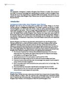
For this question, a survey had to be done on the building quality of Rugby within the central business district. The centre of the town and the edge of the central business district were both analysed. Two very different areas (edge of town, and middle) were done to see if there would be a contrast in the building quality, and if the quality changed with distance from the CBD. On the survey (fig. 3) there were several conditions which ranged from Material (whether attractive or clean) to the Landscape (trees/grass/plants). These factors were chosen because they seemed to be the most crucial to analysing the building quality of Rugby CBD. A rating system was used that stretched from -3 to 3, as this would be an easy way to show the variations in quality as the distance from the CBD increased.
Traffic flow in Rugby CBD
To discover whether the traffic flow changed throughout the CBD, a point was chosen along each transect in the CBD. This point was chosen by taking the centre of the CBD, and deciding an equal distance along each transect that was also by a road (as for some of the transects most of it was in pedestrian only areas). The amount of cars, vans and public transport vehicles were counted on each transect of a period of five minutes, timed by a stop clock. 5 minutes was used as the time period as a time length of 1 minute would not provide as accurate results, and 10 minutes would be too long. Each transect had its own tally chart and table so that the results could be compared and would easily display the differenced between the transects regarding the amount of traffic flowing through each area and also what kinds of traffic is flowing – cars etc.
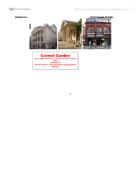
Fig. 1 (Map with transects)
Fig. 2 (Map)
Fig. 3 (Building Quality survey)