The majority of the population in Devon are elderly people, in their mid to late 50s as shown by the population pyramid. Also there are not many kids. The population pyramid for Redbridge shows it densely populated with young working people. There is a lot of people in the 30-34 category showing that people are not having kids young as they are working.
This is a Relief Map of Devon:
The South West Region, at 24,000 square kilometers, is the largest in England and represents 15% of the mainland area. As a peninsula, it is over 350 kilometers from the south western tip of Cornwall to the northern border of Gloucestershire.
There is a great range in altitude across the Region, with the highest points from 330m in the Cotswolds to the north, south through the Forest of Dean (279m), the Mendips (305m) and Salisbury Plain (212m) to the uplands of Exmoor (520m), Dartmoor (621m) and Bodmin Moor (419m). Between these upland masses are relatively flat areas, vales and river valleys and coastal strips.
In Comparison, Barkingside is a very urban area and is very built up. There are many human features, such as many houses, with many residents, and many shops. These shops are mainly tertiary. There is a school, a library, a swimming pool and many other services provided. It is a very large place and is densely populated. There are many roads, with many forms of transportation around, such as cars, buses and trains. The population structure varies widely from the younger population to the older generation. There is not a lot of land around, as it is a very industrial area.
Here is an aerial map of Barkingside:
From this you can clearly see that there is little open space around, only a school field. There are very many buildings and residential areas too. It is a very industrial area.
This is the economic activity for slapton village, Devon. From the pie chart you can clearly see that the majority of economic activity is from construction and tourism, distribution, hotels and restaurants. There is little in the way of manufacturing as the population is small so there is not enough people to work there.
This is the economic activity for slapton village, Devon. From the pie chart you can see that there is wide range of economic activity. Each activity is split fairly equally, however, the biggest one is wholesale & retail trade. This is because the population is big meaning there are lots of people to buy and sell stuff to supply their wants and needs. Also, there is 0% agricultural activity. This is because Barkingside is a very urban area meaning there is no land for this type of activity.
Crime is tackled locally by Crime & Disorder Reduction Partnerships (CDRPs). These are a partnership of the police, local authorities and other organizations whose aim is to tackle crime and disorder on a local level.
As you can see from this table, there is quite a high rate of crime in Redbridge.
- In Devon in 2006/07, the combined rate for the key offences in the chart below was 24.5 per 1,000 people. This is much lower than the SW and England rates (33.5 and 42.2 respectively).
- This was a fall of 1.2% on 2005/06.
-
Exeter and North Devon have the 8th and 13th rates of the 45 SW districts and unitary authorities (39.8 and 30.4 respectively).
- None of the other 6 Devon authorities has a rate above 23 per 1,000.
Also, the 2001 Census documented the rate of unemployment as 3.6 % in Redbridge (3.3% for England, and 4.4% for London). Church End ward had the lowest unemployment rate (2.4%) and the Loxford and Valentines wards had unemployment rates (5.6% and 5.5 % respectively).
- At only 1.1% of the population, Devon has a considerably smaller proportion of ethnic minorities than the South West (2.3%) and England (9.1%). Of the districts, only Exeter has a significant non-white population (2.4%)
There has been significant increase in minority ethnic population in Redbridge in the last decade. In 2001, Redbridge’s minority ethnic populations accounted for nearly 36% of the total population compared with 21% in 1991. The figure in England increased from 6% to 9% over the same period. In Redbridge, people of South Asian origin (Indians 14%, Pakistanis 6%, Bangladeshi 2%) form the largest minority ethnic group, followed by Black Caribbeans (4%).
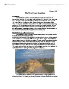
The highest point above sea level is 120 – 140. This is high land. The majority of the land in Devon is high. As it is high land, farming is hard because the land is not flat; meaning is it good for pastoral farming. Slapton good be easily flooded because there is a lot of low-lying land as well as being near the coast.
The highest point above sea level is 40 – 45. The land is very flat and it is easy to build on. It would have been good for farming but the population has increased and has been urbanised. Barkingside is high above sea level meaning it is harder to flood at is has to travel a longer distance.