In the investigation we aimed to test the hypothesis “Land use will change with increasing distance from the CBD”. In order to test this we need to find out how land is used between the centre of Blaydon and the periphery. I recorded this information on an A3 map of the area with the transect route marked on. As I walked to each sample site, I recorded the information on the map by annotating it. I did this by marking specific points on the map e.g. the car wash and petrol station. The only major problem with this part of the data collection was determining if certain properties were industrial or residential.
Also in this investigation, we aimed to test the hypothesis “Housing age will become younger with increasing distance from the CBD”. To test this hypothesis, we needed to find out the age of houses and their position in relation to the CBD of Blaydon. I recorded the age of houses on the A3 map next to where they were located on an information sheet. When we stopped at each sample site, the teacher told us the ages of houses which were very useful in order to collect some reliable data.
We also aimed to test the hypothesis “Quality of life will improve with increasing distance from the CBD”. To test this, I did an environmental survey at each sample site. I did this by giving a site penalty points according to quality of life in that particular area, six points being the worst and zero being the best. The factors that I tested each sample site on were landscape quality, if the land was industrial or environmental, the quality of housing, noise level, traffic flow, air pollution and amount of litter and vandalism. I recorded this information using an environmental survey sheet, and then used that information to create a bar chart. The bar chart will show all the information collected, this bar chart will be included in the Data Presentation.
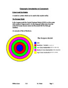
Overall, this investigation worked well and I recorded all the data required. I aimed to establish if the Burgess land use model is relevant in towns today. I done this by using my hypothesises to test whether housing age, quality of life and land use will all change when increasing distance from the CBD. The only problem we encountered was when we rotated jobs, the results varied as it relied on people’s opinions which will differ.