'Investigating Wakefield' - The overall topic of this investigation is land use within settlements.
'Investigating Wakefield' - GCSE Geography Coursework
The overall topic of this investigation is land use within settlements. Urban land areas in towns and cities have got very complicated land use patterns and the industrial city of Wakefield is no exception. It has grown and developed over hundreds of years and now has a thriving population of around sixty thousand.
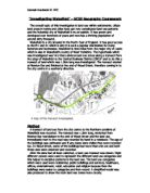
Wakefield is a city situated in the North-East of England. It has good access to the M1 and A1 which is why it is such a popular destination for many factories and businesses. Wakefield is nine miles from the major city of Leeds which is also in Wakefield's county of West Yorkshire. The hypothesis which was investigated was 'Are there obvious land use zones along a transect from the edge of Wakefield to the Central Business District (CBD)?' and to do this a transect of land which was 1.5km long was investigated. The transect started at Newton Bar and finished at the end of Wood Street, therefore coming in to the city centre in a southerly direction.
Method
A transect of land use from the city centre to the Northern outskirts of Wakefield was recorded. The transect was 1.5km long, stretched from Newton Bar roundabout to the end of Wood Street and the land use immediately next to the road was recorded by hand in a notebook. The age of the buildings was estimated and if any dates were visible they were recorded too. In Wood Street, some of the buildings had more than one use and both these uses were observed and recorded.
After the data had all been collected, a land-use transect was drawn. Eight different colours were used to represent the different land use categories and this helped to decipher patterns in the land use. The land use categories which were used were residential, public buildings and services, healthcare, offices, entertainment, retail, education and religion because then the buildings were easier to categorise and then record. A simplified model was also produced to show the main land use zones more clearly.
Description of the Area Studied
The area of Wakefield which was used to carry out the hypothesis on was a transect of 1.5km and stretched from Newton Bar Roundabout to the end of Wood Street in the CBD. Newton Bar is about one mile from the CBD and the transect studied enters the city in a southerly direction.
The area at the beginning of the transect has terraced housing and is slightly run down but industrial because it has a council construction site and a development department in close proximity, and a new housing estate is now being built. The quality of buildings improves as one goes further along the transect towards the CBD, the houses on St. John's North, Wentworth Street and Wentworth Terrace are particularly smart and elegant. As one walks down Bond Street and Wood Street, one sees buildings such as the County Hall, Crown Court, Police Station, Wakefield Museum and Town Hall which are superb examples of magnificent architecture.
When one reaches Cross Street, the more commercial part of Wakefield begins with lots of small shops and businesses such as cafes, hairdressers and estate agents. There are also bars and other forms of entertainment such as internet cafes as well as 'quality' stationers, book shops and music shops. This area of Wakefield is quite clean and well maintained although some of the buildings were probably built in the 1960s and are therefore less attractive. The pictures below show some of the different land use in places along the transect.
Results
The results were recorded by ...
This is a preview of the whole essay
When one reaches Cross Street, the more commercial part of Wakefield begins with lots of small shops and businesses such as cafes, hairdressers and estate agents. There are also bars and other forms of entertainment such as internet cafes as well as 'quality' stationers, book shops and music shops. This area of Wakefield is quite clean and well maintained although some of the buildings were probably built in the 1960s and are therefore less attractive. The pictures below show some of the different land use in places along the transect.
Results
The results were recorded by hand in a notebook as the transect's land use was observed and then a land use transect from Newton Bar to Wood Street was drawn as I have described in my method above. A simplified model was also drawn later to show the main land use zones more clearly. This model shows that there are five main zones along the transect, each being different in size and length. The zones are, coming out in order from the CBD, retail, public buildings/services and offices, education and healthcare, residential and public buildings/services. These zones reflect the types of land use there are in Wakefield.
Discussion - Interpretation and Analysis of Results
Zone 1
Zone one on my simplified model of land use is retail. This zone is in the middle of the CBD, starts at Cross Street and ends at the end of Wood Street. The land use there is mostly for shops and small public services or businesses. There are cafes, hairdressers, estate agents and lots of other small shops. These types of businesses are in the CBD because it is a typical type of zone to find in the middle of the city and because of accessibility. The businesses within this zone need to be in the CBD because their customers need to be able to get to them easily and if they are in the CBD there are lots of easy ways for them to do this - for example public transport and nearby car parking. It is good for these land uses to be in the CBD because it is the most accessible place to be situated for customers and they receive a lot of deals with passers-by who happen to go into their shop/business/public service or else inform other people about it. However, as the land prices are usually high in the CBD, only successful businesses are able to afford it. In Wood Street most of the buildings are old terraced houses which could also be a reason as to why these businesses are situated there, because lots of the buildings in Wood Street had flats or offices on the second story of their building and so would want buildings with more than one story. This type of zone would also be found in other cities, as it is a typical zone of a CBD.
Zone 2
Zone two of the model consists of public buildings/services and offices. This zone begins at Bell Street and ends at Chancery Lane and included in this zone there are buildings such as the County Hall, the Crown court, the Town Hall, Wakefield Museum and the Police Station and offices. These buildings are where they are because they couldn't be in the CBD as they would not have been able to afford the land prices but they still needed to be near it so that they are accessible for visitors and workers. They are also on the major road to Leeds so they have good transport links. Another reason for these buildings being there could be so that the council could keep all its buildings together and so that everyone would be able to find the council buildings easily, without having to travel all over Wakefield to find the one they wanted.
The buildings which are in this zone are all old, the County Hall was built in 1898 and many of the buildings have pillars outside the building which implies that they were built quite a long time ago. However, if the people who work in these places have to pay for the upkeep of the buildings, then this could be why they are not situated in the middle of the CBD - they do not have enough money to purchase land in the city centre. This type of zone could be found elsewhere in Wakefield because only one transect was investigated, which means there would be other transects possible to investigate on the other side of the CBD which implies that there could be other places in Wakefield with similar land use patterns.
Zone 3
Zone three from the model is education and healthcare and in this zone there is Wakefield College, Wakefield Girls' High School, Clayton Hospital and an 1871 dentist. This zone also includes Wakefield Art Galley and the Christian Science Building. This zone stretches form Bell Street to North Road and is in the place it is because it, again, needs to be accessible, this time for students and workers, and because the land uses in it will not have been able to afford the high land prices of the CBD. Even if this zone could have been situated in the CBD, it would not have been because hospitals and schools need space to expand their premises and if they were in the CBD there would be no space to do this. Also, hospitals and schools need to have lots of space for car parking for workers and/or students and there would be no space for this in the CBD. The hospital and school also need good transport links in order for its workers/students to get there each morning which is another reason for why they are in this zone, it is on a major road which leads to the large city of Leeds. This zone could be found in other major cities such as Leeds, but not elsewhere in Wakefield.
Zone 4
Zone four begins at the Leeds Road and stretches till North Road. In zone four the land use is mainly residential, but there are also places of religion and education such as St. John's Church, built in 1791, and St. John's Primary School, built in 1964. The housing in zone four is very varied, because there are areas of terraced houses from the 1920s-30s such as Snow Hill View, the 1960s-70s as in the houses between Andrew Street and St. John's Avenue and Georgian terraced housing in St. John's Square which is a protected heritage site.
These buildings are where they are because they could not be in the CBD as it is far too expensive but they still needed to be easily accessible from the city centre. St. John's Square will have been built for wealthy people to live near the Church as the Church would have been the centre of the community in those times. St. John's C of E School, which was originally on Kilby Street (named after the Reverend Thomas Kilby), was rebuilt nearby as it is a Church school. The houses from the 1960s-70s were built on waste land which would have been cheap at the time but still had good transport links with the city centre, Church and local schools. This zone could not be found elsewhere in Wakefield but a similar area might be found in other cities.
Zone 5
Zone five is between the Leeds Road and Newton Bar and it consists of mainly public buildings/services, although there are some terraced houses and quite a lot of open space. Included in this zone are 'The Green', a council construction site, the Development Department, and the Vine Tree public house.
These buildings are where they are because they could definitely not have been in the CBD, as they require a lot of land and room for expansion which would not be available in the city centre. However, even if there was suitable land available for these land uses in the CBD, it would have been too expensive for the businesses to afford and so they would have been forced to build further away from the centre anyway. As many of the workers in these buildings would come to work by car, these buildings also require space for car parks and good transport links, both of which they have. This zone would probably not be found anywhere else in Wakefield but it is very likely that other cities have parallel zones.
Conclusion
I found that, in Wakefield, there are five main land use zones and that as one goes further away from the city, the amount of housing increases. There is also more open space further away from the CBD which is not surprising as most businesses want to be in the city centre so their customers can have easy access and so that they get trade with people who happen to pass by. I also found that there seemed to be a greater concentration of shops and offices in the CBD but that there were also quite a lot of public buildings/services as well. There were no residential areas in the CBD which suggests that people prefer to live outside the city centre and go in each morning for work. I think that Wakefield's land use zones are quite similar to the Sector Model of land use so this suggests that Wakefield is a typical city.
Evaluation
I did this investigation to find out if there are obvious land zones along a transect from the edge of Wakefield to the CBD and I found that there were. Overall I think that the investigation went well but that it could have been better if I had not had to go out to study the transect on two different days.
If I was to do this investigation again, I would investigate the transect once, in one session, and then I would go out at another time to record the landuse again. This would make my results more accurate because if I did the investigation twice, I would be able to match up the landuse on each set of my results and make sure I had not missed anything out the first time.
Hannah Hardwick VL VEC