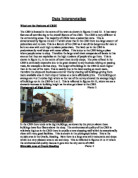
Many tourists visit the Tuol Sleng Genocide Museum, the infamous prison of the Khmer Rouge, and Choeung Ek, one of the main Killing Fields - both display photographs, skulls and bones of victims of the auto genocide.
The country has many raw products which are exported, like rice, fish, timber and rubber. Rice is mostly farmed on the flood plains of the Tonle Sap, where the ground is full of nutrients and well irrigated. Deforestation is a large problem in the country. Two centuries ago most of the country was forest, but now, with timber exportation at a high, trees are becoming scarce.
The New Capital
I have looked at the climate, relief, resources and population distribution and have chosen a location for a new capital: Kâlâh Rêni – 'City of Harmony’.
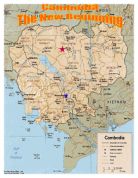
At first I thought of building the city on the banks of the Tonle Sap, which would not only open up the centre of the country but also provide a brilliant water supply. It needed not much research to realise that such a city would have to be evacuated every winter when the Sap is 9½ times its normal size. Apart from the confluence where Phnom Penh is based, the Sap is the only water mass large enough to cope with the needs of a city without being irrevocably damaged. So the city would have to be close enough to the Sap for water pipes to tap the lake but far enough away to prevent flooding. As backup I could channel mountain springs and rivers into reservoirs around the city.
That led me onto a second thought. Rivers rushing down mountains into a reservoir? A hydro-electric power plant. Expensive, definitely, and for a while the comeback would outweigh buying electricity from other countries, but once it reaches full capacity that would not be a problem.
What about Angkor Wat? Should the city be far away, so as to stop the ancient city from being damaged? Or close so that tourists could visit both the new capital and the old together? Somewhere in the middle, I believe.
Then I thought back to how conservative we would have to be in drawing water out of the Sap to avoid repercussions downstream. Perfect – I had my location. And it only took me three days.
The City
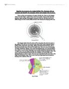
Now that I have found a place for my city I need to design the layout of the city. Fig 1.1 and 1.2 show my plans for the entire city layout and for the CBD itself. Here is the key:
= Reservoir/Canal
= Mountain/Hills
= Cultural Monument
= Shops/Markets
= Offices/Tertiary Industry
= Governmental Buildings
= Rich Housing
= Lost Cost Good Quality Housing
= Land for Self-Development Scheme
= Roads (for pedestrians only in the CBD)
= Train Station (Underground)
= Train Station (Overground)
= Sihamoni Airport
= Amusement Park/Leisure Centres
= Hotels and Water Based Activity Centres
= Jayav Hydro-Electric Power Plant
= Water Cleaning Plant
Power and Water Supplies
I have planned to build to large man-made reservoirs on either side of the capital to bring water and power to the city. The northern reservoir will be filled both by channelling mountain springs and by water piped from the Stoëng Srêng. This will be a water supply for the city and a source of recreation. Hotels and luxury housing will be built along its bank to take full advantage of the picturesque reservoir/mountainous landscape. To draw more visitors to the area a string of activity centres will provide sailing, diving and mountain walks. The traditional water and rowing festival of Bonn Om Teuk will be celebrated here.
The other reservoir will be the main source of water. Two different schemes will bring fill it – one in the south and one in the north. When the Tonle Sap floods in the monsoon season the huge amount of water that is not used by the nearby rice fields and causes dangerous flooding downstream will be channelled into a hydro-electric power plant (where the Tonle Sap flows into the Tonle Sab) then piped to the reservoir up north. The second scheme will be another river up in the mountains east of the capital which will be diverted to the basin. These mountains are very steep so the driving force will be perfect for another HEP plant.
I have shown two ways of bringing electricity to the city using water, but the last is using another natural force abundant in Cambodia – the sun. On the huge plain north of the city in between the Stoëng Srêng and Stoëng Sên I will build a solar power plant. SP plants are controversial issues worldwide - while many people champion SP as an environmentally friendly way of banking electricity, others insist that they are inefficient and an eyesore. I am one of the former. While I accept that in countries like Great Britain SP is near useless, it is the perfect solution for Cambodia. Although I personally think they look stylish and modern, many people disagree. Its location, the plain of Siêmréab-Ôtdâr Méanchey, is completely deserted due to the soaring temperatures in summer so the plant will be hidden away out of sight.
Transport
The city will be quite far from any other settlement, and certainly very far from any big ones. Links to other towns, cities and Angkor Wat will be available by overground trains.
An airport will be built on the outskirts so that the capital can be linked to the outside world, not just the nearby towns!
Cars will feature as a part of the city – but because of the problems with regards to the environment schemes will be heavily promoted to reduce these effects, for example a mainly car free CBD and funding publicly run environmentally friendly trams and underground tube network. Cars and buses will play a larger part outside of the CBD, as although the same public transport design will run, it will not be able to cope by itself.
Although at first the five point gardens seem a great problem for transport, but tunnels will be built underneath not only for the tube network, but also for cars and buses out of the CBD.
Jobs
As a completely new capital, there will need to be strong pull factors to draw people in. The first factor will be jobs.
Even before a single brick has been laid down there will be a need for hundreds of architects and scientists. Once they have done their work, thousands of surveyors and builders will be needed. When, after a seven years or so and the city is ready, builders will be loathe to leave the city which they have been building with their own hands for years.
The next to move in will be the manual workers needed to run the city from behind the scenes – the people needed to work in the power plants, the sewage treatment plants.
Then commerce - every type of vendor from corner shop owners to global multi-billion pound companies must be attracted to enter the city and set up camp in the city.
Thousands of trained police, doctors and nurses and fire fighters will have to have been trained in other cities during the building and will be ready for a smooth transfer to the new city. Also necessary are a large amount of teachers, and so advertising for teachers from abroad will be needed far in advance.
Gradually, starting off with the manual workers then shopkeepers, homes will fill up and more and more people will flock to the City of Harmony.
I have tried to keep shops in long, linear sections, so that they will be able to serve the largest residential area. I am hardly saying that shops can only be in these strips, but these areas will originally be where the government builds shops. The city is not a collection of bricks, but is a live, living creature which will grow and change. My plans for the locations of buildings are not strict rules.
One large source of income for the city will be tourism. The capital will be a marvel of modern architecture, as well as a monument to the history reflected in Angkor Wat, an hour away by train, and the central piece to the city:
Luuma Nârta – The Temple of Light
The Temple of Light will symbolise the whole of Cambodia and be the centrepiece of Kâlâh Rêni. It will harmonise the different religions, the old world and the new and the progress from war to peace. It will be a huge temple in the middle of the city, with architecture in Buddhist, Islamic and Hindu styles. It will be visible on the horizon throughout the city and at night there will be light shows to illustrate Cambodia’s harmony between the old and the new.
Therefore hundreds, probably of thousands of jobs will be created by the tourism, from tourist guides and museum curators to ice cream and souvenir sellers.
Housing
In Brazil’s new capital, Brasília, housing was badly mismanaged. All the housing in the city was rich, luxury apartments unaffordable to by far most of the country. It became a rich man’s playground, full of international tycoons.
In Kâlâh Rêni, there will be rich housing. And there will be, middle class housing. And housing for the poor. The rich will, as is the way of things, get prime housing around the CBD and near the reservoirs. But they will be a minority, because most housing in the city will be good quality apartments (not high rise) which, due to government grants, will be affordable for most of the country.
All cities expand, especially in LEDCs where the population as shooting up. The government can not afford to build and equip houses for the millions who will probably be living here in 50 years. Enter:
The Self-Improvement Scheme
This is a plan designed specifically for the millions who in most LEDCs are drawn to the capital with dreams of a better life, only to find themselves living in shack with a meagre, if any, source of income.
In so many cities – Rio de Janeiro and São Paulo in Brazil, Calcutta in India – people are forced to build their own homes from whatever scrap materials they can find on the street. But other cities have plans in action which help these people.
The scheme I have chosen helps these people start a home. Houses would be built out of breeze blocks with running water and electricity, and the families would be given materials to improve their home. While this is comparatively cheap for the government (allowing them to build many such homes) it is normally the hardest part of the settlers’ work.-
Emergency Services
Good emergency services are absolutely vital for the success of the capital of a developing country. Rio de Janeiro, for example, has allowed crime to thrive for too long, and the city has a world reputation for danger. Walking on the streets after dusk is suicidal and even in broad daylight wearing a watch in public will get you mugged.
Police, hospitals, ambulances and fire fighters will be completely funded by the government. Police, doctors, nurses and firemen will, as I have previously said, be trained in other cities, prepared for a smooth changeover.
I have said that hospital will be state funded, but like with schools, private hospitals will be invited to take root in the new capital.
Education
Literacy levels are not high in Cambodia, so the whole concept of it being compulsory for all children to attend school up until 16 will be strange. There will have to be advertising for teachers from abroad far in advance of the completion of the city. I hope that by the time the city is finished, foreign teachers will have trained enough qualified men and women to fully staff the state schools and universities. There will be the opportunity for private schools and universities to enter the capital as well. By the time the city is finished, the education system will be put in place in Kâlâh Rêni, and will hopefully spread to other cities.
Once it has begun to evolve, Kâlâh Rêni will be a beacon throughout the east. It will show that if a country that has gone through the problems Cambodia has can persevere and recover, any country can.