Corrosion
This is when the acids in the river dissolve the rocks on the river bed, they are normally the weaker rocks such as limestone. This process can occur in any part of the rivers course.
Down cutting
This is a process that removes the material from the river bed and therefore deepening the channel of the river. The rate of down cutting depends on the rivers base level which is the lowest point that the steam can erode.
V-shaped valleys
The river creates a v-shaped valley which is caused by any spare energy in the river near to the source. This spare energy is used to transport large boulders along its bed. This results in the river cutting directly downwards, this process is called vertical erosion. Vertical erosion leads to the V-shaped valleys and the development of steep sided, narrow valleys. The valley sides are steep because of the heavy rain moving all the loose rocks and easily penetrated soil. The material from this is then added to the river content, making the erosion worse. The river itself is forced to divert around hillsides, the hillsides that are known as interlocking spurs. The V-shapes are mostly found in highland areas just like Burbage Moor. In many of the meanders and bends in the course of the river there are many river cliffs, which meanders are characterized by. These are cliffs on a river, which over hang where the river has eroded the outside bend. The outside bend is eroded by a mixture of hydraulic action and abrasion. This creates an overhang of material which can be destroyed if the erosion underneath becomes too much, this will make the cliff collapse as there is nothing supporting the weight.
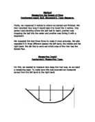
River cliff shown in the diagram
River rejuvenation is caused when a river cuts down into its channel and it will leave behind it, its old flood plain on the valley side to form a river terrace. Meanders in the river then become deeper and the side for the river become steeper because of this, this then forms incised meanders and waterfalls which become more common in the river.
Lake District
A good example of a fluvial landscape is the Lake District, as it has many different rivers and lakes, with the different types of erosion.
In the Lake District, 500 million years of many different geological processes have produced a landscape of many mountains and lakes. Its features mostly represent periods of glaciations, the most recent being around 15,000 years ago. These include the Valleys and lakes that give the park its name. The upper regions contain many glacial cirques, which are filled with tarns. The higher fells are very rock and are made up of a very strong rock type, the lower fells being open moor land. There are many nineteen century plantation which cover the landscape.
The ice ages have produced glaciers that have cut the landscape and forming many smooth U-shaped valleys and steep sharp ridges. The Lake District also holds England’s highest mountain and the deepest and longest lakes.
There are so many lake because of the volcanic rock, which doesn’t allow water to seep away as it is a hard rock type. The high average rain fall percentage and the glacial valleys, mean that the valleys are able to store large volumes of water with out it escaping.
Honister (picture)
A U-shaped valley carved out of volcanic rock by glacial action. Leaving a very smooth glacial U-shaped valley.
Striding edge (picture)
The glacial impact on the Lake District can be seen though the many valleys and sharp mountains.
The oldest rocks are Skiddaw Slate series and Borrowdale Volcanic series, dating back to around 500 million years ago. The Skiddaw slate is found in the north of the part and is thought to have been deposited in shallow seas. The Borrowdale Volcanic rocks are lot more resistant to weathering and form the highest peaks in the Lake’s; this is because of it being resistant to most forms of weathering. Forms of igneous rock are in both of the series. The other large rock group is the Silurian Windermere Group which is made up of limestone that rests upon the volcanic rock.