The information that I obtained about industrial usage in the Mill Hill area in 1895 was, that first I was given an industrial base map of 1895 on Mill Hill, What we did then in class was that we located each industrial site, there were 11. Then we came to visiting the Blackburn library, which we used to find the Ordnance Survey map of 1895, we located the 11 sites and recorded their names. Thereafter for 1895 we found the firms and what industrial activity took place from the trade directory. Following that we transferred the data of the 11 sites onto a table, 10 consisted of textile mills and 1 of Brick and Tile Manufacture, due to there being many textile mills it was decided to split them in to 3 categories: Weaving, Spinning and Spinning and Weaving.
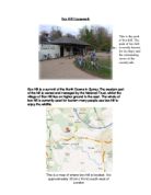
To assemble all the data on 2004 we were given a base industrial site map and located them, before visiting Mill Hill we highlighted the sites, thereafter we took the map to Mill Hill and worked as group. We visited all 28 sites and used a numbering system, which was then transferred on to a data-recording sheet to sustain in order. What we then discovered with the old and large textile mills was that we had to record more than 1 firm so; we recorded them individually by writing them under the sites name. Thereafter seeing that the map was inaccurate, we found new developments, and old sites demolished, we altered the map accordingly, which was modernized to help us locate the sites.
On returning to school we decided on the industrial category which was relevant to the 2004 industrial data, we were then able to complete a data sheet showing all the details of the 2004 industrial sites data which we recorded. Following that we converted the data into 2 periods of time 1895 and 2004 pie charts so, we used the industrial categories by comparing the 2 pie graphs, 2 industrial tables and 2 maps. At that precise time we were able to make conclusions to prove that industries in 2004 are more diversified than they were in the past.