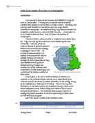
Map (C) shows a map of the Yorkshire dales
Living in a national park, like all places pros& cons. Many people enjoy living in the pleasant surroundings and the peacefulness, but during peak times the parks and their honey spots are very crowded. Looking at the table above we can see that the resident population in the Yorkshire dales has increased recently. However it seems most of these people live in small, isolated villages or in very remote places, as there are only 3 settlements with a population over 1000. Taking into account the dales has a total park area of 1773 sq. km and in the year 1999 had a resident population of 20,167, we can work out there is an average of around 88 sq. m per person living in the dales.
This says something about the way of life the locals have, they would seem to be used to their space and privacy. Many of the locals will own land and farm the land. 28% of the national park is designated a site of special scientific interest, along with the 11.6 sq. km of national nature reserve, u can see what could possibly attract visitors. They possibly come as day-trippers, which account for 46% of visitors to the park, who are here to soak up some of the views and perhaps have a peaceful walk. Heritage and cultural interest may attract some visitors to stay a few days (54% of visitors), creating the need for hotels/b&bs, already an effect of tourism.
I will answer the essay question by collecting primary data from a field visit to Grassington. I will conduct surveys on:
- Footpath erosion, footpaths must get eroded over time by excessive use of visitors, most footpaths in the dales are just tracks, they are not made to support large numbers of visitors.
- An environmental impact assessment on at least four separate sites to assess how tourism has affected the environment, number of litter bins, rubbish and noise pollution.
- A car park survey, to assess how congestion problems are solved in the town.
- A land use survey to see if tourism has affected the influx of new business and in what way.
I will also use some secondary data from the Internet, photographs or textbooks. The secondary data will allow me to make visual comments on photos, such as pointing out pollution and also allow me to use tables, like table (b), to provide a background to the area and its problems.
Data Collection
In this section I will explain how and what data I collected to find out how tourism has affected Grassington. This will help me answer the Question; what is the impact of tourism on Grassington? On Wednesday the 7th July 2004, our group of 16 visited Grassington. We went t to find out what the impact of tourism on Grassington is. We visited Grassington to collect data on the e following things:
- Land use in the center of Grassington
- Environmental Impact
- Paring in the town center
- Footpath erosion
We looked at land use to see how tourists had affected land use and the proportion of buildings for tourist or residential use.
The environmental impact assessment is use to determine the impact of visitors on Grassington, using the effects of noise, litter and visual pollution as well as traffic congestion.
The parking survey was to find out the effect of tourists and their vehicles in the town, such as extra car parks or security etcetera.
The footpath erosion survey looked at the effects off tourists walking on footpaths we were there to measure and Asses the erosion caused and also sees if it varied in some areas and why.
I have chosen to write up the following surveys:
-
Environmental Impact Assessment - I chose this, as it seems a good way of comparing one site to another and assessing the differences between them and finding out the causes of these differences.
- Parking Survey - this seems a good way to assess how tourist and their cars have affected the local way of life and their surroundings.
- Footpath Survey – This would help answer the concerns that large numbers of tourist can erode and damage the footpaths.
Footpath Survey
As I mentioned before, this survey will assess the impact of large numbers of visitors on the paths and footpaths in the countryside. On popular footpaths erosion can take place generally and in places that tourists may congregate and gather together, causing the footpaths to wear away considerably in a short amount of time and in a condensed area. I think tourist are the main cause of the erosion but it is probable that; locals will contribute in some way or form.
The erosion can be set down in four separate stages, first there is meadow grass which is lush, green and even eventually this is worn down and the affected area turns though tougher Broad leafed plants, then the plants and grass start to die off, finally leaving exposed soil, which is easy to erode.
We chose a footpath, heading towards Grasswood, which runs along the edge of the River Wharfe and is a very popular footpath with visitors. The path runs along the R. Wharfe next to Lenton Falls and it leads to the major car park at Calvend. The completion of this survey will hopefully help me answer the question of how has the impact of tourism affected Grassington
We measure a 100m section of footpath spilt into twenty transects as we did not have enough time to measure every bit of the footpath. We collected data every ten meters. A transect is a section in this example it is every 10m.
There were 16 in my group. Every 10m, using pieces of string, we collected data.
Footpath
100m
The string was placed across the footpath and pulled tight. The string, which was used as a marker, as it had knots every 50cm this is where we measured the depth of the erosion across the path.
String
Cross-section of footpath
We chose this method to as it allowed us to effectively measure the erosion of the path and see if it was even or concentrated in certain areas. We recorded the results on a data sheet. We split into pairs and we each did one section of the survey, we then swapped data with other pairs so we had a complete data sheet. This is some people swapping their results.
Environmental Impact Assessment
This survey is to assess how tourism has affected the Grassington In environmental and pollutional ways. This is to determine the impact on visitors on Grassington. We chose the following 5 sites as they are in different parts of the town allowing us to make better comparisons and conclusions by using a wide variety of sources.
- Town Head
- The square
- Town end 9station Rd & Wood lane)
- Colvend Car Park
- Wood lane
We decided that if Grassington had been affected there would almost be sure signs of it in the environment; I decide that these could be classified into two types. There are the first hand effects example litter, erosion of footpaths and then the responses to these effects such as the presence of litter bins and netting over footpaths to help prevent erosion.
We rated the sites in four different categories, these were
- Litter
- Noise
- Traffic Congestion
- Visual Pollution
They were marked using the following scale
Scoring: 1=Very Poor, 2=Poor, 3=reasonable, 4=Good, 5=Very Good
Car parking survey
Every car that is brought into Grassington affects the local way of life by:
- Increasing traffic noise and pollution levels (these are also assessed in the EIA).
- Encouraging small, local roads to be made wider and for scenic areas to be turned into car parks.
- Increasing congestion in the centre of the village
- Putting pressure on car parks and therefore encouraging parking on roadsides, which is both damaging to the wildlife and also unsightly
Some of these points will be assessed in the EIA, however I am now going to study the parking aspects of cars and the impact they have on the environment. This survey will assess the impact of visitors and their cars on the roads, car parks and local way of life in the town.
The car parks we chose to survey were:
- Colvend car park
- Wood lane car park
- The square
- Town head
In the town the centre are small and narrow, they are obviously only designed for local traffic. This could cause problems as it could cause congestion in the villager. Heavy god s vehicles or coaches, busses could cause further problems in the village. Residents may get annoyed with the visitor for several reasons, such as parking on grass verges and the increased conpetition for parking spaces. The survey will look at badly or illegally parked vehicles and will look at the use of designated car parks.
Presentation of my results
Foot path erosion survey
To effectively demonstrate the level of erosion at the different sites on the footpath I am going to create an individual graph for each site.
I am going to present the data in a scatter graph where the points a joined by smooth lines. However I am going to make the graph so that on the level of erosinon scale the level of erosion DECREASES as the scal goes UPWARDS. This will mean we will have a cut view of this section of path.
Eg.
To supplement this I will also produce another grapth for each tansect of the footpath, this grath will be to make accurate readings from the grapth.