The causes of erosion on the Walton coast is mainly down to Long shore drift and prevailing winds causing the waves to crash against the cliffs. We found this out by measuring the distance a Satsuma travelled along the sea in the space of 1 minute. One member of the group placed the Satsuma in the sea and stood still on the spot it was placed it, another then walked the distance the Satsuma was traveling and stopped where it stopped at the end of the time. The distance was then measured by another member and the results were recorded. We repeated this three times and then came up with the average. The average was 6.53 metres.
Another experiment we did was counting the number of waves each minute for 10 minutes. We did this in order to determine whether the waves were constructive or destructive waves. Our average at the end of the experiment was 15.1 waves breaking per minute therefore the waves at Walton are destructive.
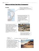
We could clearly see the cliffs had been eroded due to the pillboxes that were on the sand. Around 60 years ago, the pillboxes were on the top of the cliffs, so this shows that the cliffs beneath the pillboxes had been eroded gradually over time. You could also tell from this where the cliffs once were and how much they have eroded since then. From seeing this, I think that in about 40/50 years time, the land and facilities that are on the cliffs will totally disappear down to erosion.
By examining the cliffs and sampling it, I could see that the cliff material was made up of mainly, small pebbles, sand, shingles and London clay. They were quite dark coloured with oranges, yellows and browns. There was several layers, that were all mixed colours, some with vegetation growing from it and parts with no vegetation at all. They were not vertical, this is due to erosion.
After doing all the experiments, examining the cliffs and looking at the effects of erosion and what its doing to Walton’s coast, we done a questionnaire to determine people’s perceptions of the beach and by the end of it, most people said they do think Walton ought to be protected as best as it can be as they think it’s a nice place for future generations to visit.
On our trip, we also visited East Mersea. We took a look at the sea defences used at mersea, like the Whale back Groyne and the sea wall. We walked along the shingle beach, which had vegetation and marsh land all around it up to the spit end. The spit is formed when the long shore drift carries the material along the coastline, the deposited material forms the spit. Then, over time the spit grows and develops a hook, if wind direction changes further out. Waves cannot get past a spit, which creates a sheltered area where silt is deposited, and mud flats or salt marshes form.
Here is a diagram of a spit.
When in West Mersea, we looked at the number of sea defences used there. One sea defence used was Groynes. We also did an experiment to determine the direction of long shore drift on the beach. To do this we had to measure 3 different Groynes along the beach on both sides and 3 different positions along the Groyne. The side that was the smallest was the side that long shore drift deposited its material. Therefore that’s the direction it is going.
I believe more can be done to protect both Walton and Mersea’s coast. In order to sustain the tourist attractions and the amount of money coming in to run the businesses, they both need to be protected from erosion. If nothing more is done about the risk of erosion, slowly over time, the land will disappear and the houses and shops will collapse. People will lose their homes and businesses, therefore the whole area will be losing money.