In map 2 my results showed that:
In map 3 my results showed that:
``These results show that there is double the amount of clothes shops than food shops in the centre of York.
My results also showed that there is over five times the amount of food stores than clothes shops further away from the centre of town.
In my opinion this is because clothes shops are high order goods, they have higher profit margins and as a result need a high threshold for shoppers and an accessible location because of their high profit margins they can afford to cater for this by buying a central location.
However food is a low order good and has a low profit margin. Because of this they must sell in bulk and cannot afford a central location and need space so have to buy a cheaper out of ton location.
However household goods appear to be an anomaly and instead of they’re being a greater amount in the centre of York they are nearer the outskirts.
Anther pattern I have found is that there appears to be more services were there is less food and clothing shops this could be because it means less competition.
I have also noticed that there is very few vacant shops, this is a good sign for York and shows it is doing well in the retail market.
In my opinion the only limitation that occurred was that we should have been aloud to collect results from more of York than the few streets we were allocated, in order to get a wider prospectus and clearer more precise results.
The hypothesis I chose was “There are more clothes and household stores near the centre of a large town, when compared to food shops.”
After analysing my results I believe there is more clothes shops than food shops in the centre of most towns. But I don’t believe this with household shops, as my results show that part of my hypothesis to be correct.
If I were to do this again I would research a wider area of York and would also collect results from other large towns, in order to get more accurate results.
There are more multiple or chain stores, near the centre of York, compared to independents.
I chose to investigate this idea because it would be a good way in which to see how important multiple chain stores are in the middle of York.
I expect to prove my hypothesis correct and be able to distinguish between independent and multiple chain stores clearly.
I also believe my findings will have a lot to do with bid rent and also the ability to bulk buy.
A multiple chain store is a store with more than one branch and often has a higher profit margin than independent stores, and because of higher r profits are higher up in the economies scale because they can afford to bulk buy.
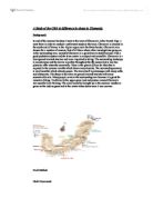
In order to find out if my hypothesis is correct I recorded which shops were multiple chain stores as we walked through Piccadilly to Gilllygate. In order to do this we were given three maps, which showed diagrams of the shops at each side of the streets, we walked down.
One problem, which occurred, was that I found that o didn’t know if some shops were independent or multiple chain stores. I overcame this by going in and asking one of the shop assistants in the shop which one it was.
I also did a pedestrian count at four points on each of the three maps in order to see which areas are most popular.
In map1 my results showed that:
In map 2 my results showed that:
In map 3 my results showed that:
These results show that most department stores are found near the centre of York and very few are found near the outskirts. This could be because of bid rent. Only the department stores can afford to pay the expensive rent for central town locations. Shops want the central locations because there are more shoppers there, which mean there are more customers there, which as a result means there is more profit in a central town location. This is proven correct as my pedestrian count shows that there is a much greater number of pedestrians in map one, two than three.
The only limitation I recognise is that we were not aloud to explore York further in order to make it a fairer test.
I conclude that this hypothesis is correct, “there are more multiple or chain stores near the centre of a large town, when compared to independent stores”.
I have come to this conclusion based on my findings which clearly show that most department stores are situated in map one and two and that most people shop in map one and two.
This proves that: MORE SHOPPERS = MORE CUSTOMERS = MORE PROFIT
This equation also shows why multiple chain store can out bid individual stores when it comes to bid rent.
However I believe in ten years time most chain stores will be in out of own shopping locations like meadow hall and monks cross as a result of more people buying cars. Shops in the centre of town could also decrease due to catalogue and Internet shopping, increasing in popularity.
The quality of the shopping environment increases towards the centre of York.
I chose to investigate this idea because it was a good way in which to compare shopping environments.
I expect there to be more amenities and a better quality environment towards the peak land value point of a large town.
I expect the environment to improve near the centre of York because it is most pedestrianised and generally has the most amenities because it is were most high order goods and chain stores are found making it a richer part of town.
The “quality of the shopping environment” means things such as age/quality of buildings, quality of window displays, pedestrian safety, noise/traffic pollution, litter, amenities, phone boxes and if its cramped.
We measure these factors because we decided that they affected the way a town was thought upon.
We had to think carefully about how we were going to record the results. This proved difficult. Eventually we decided upon drawing up table scoring each factor from one to five at four different points on each of the three maps. My scoring system is subjective.
One of the problems I found was scoring the factors correctly I found the only way to do this was to use your initiative. This method is also subjective. Which means different people would have different ways of scoring.
The highest environmental score was found at point four which is near the end of map 1. In my opinion this is because its were most of the big chain stores are found, it is were high order goods are marketed and because it has the highest number of pedestrian as shown in my graph, which shows the relation between pedestrians and the environmental score.
The lowest environmental score was found at point eight, which is near the end of map two and is were the least number of pedestrians are. This could be because the majority of the shops are selling low order goods or providing a service so are not attracting the same numbers 3,4,5 and six would as they are in the centre of York.
My scoring system is subjective, my pedestrian counting system could be criticized because it may not be very accurate as we scored it by one person facing one way and another person facing the other, counting the people coming towards you using a tally chart. However my graph, which shows the relation between the pedestrians and the environmental scores, show a positive correlation and most of my result match with this.
My results proved there to be more amenities and a better quality environment towards the peak land value point of a large town and the environment to improve near the centre of a large town because it is most pedestrianised and generally has the most amenities because It is were most high order goods and chain stores are found making it a richer part of town.
There are more banks were pedestrian numbers are high.
I chose to investigate this idea because it would be a good way in which ………………………………
I expect there to be more banks were pedestrian numbers were high. I expect this because in the centre of York towards the peak land value point it is generally more pedestrianised and has most amenities because it is were most high order goods and chain stores are found making it a richer part of town and the most profitable place for banks to be.
In order to prove my hypothesis I recorded each bank as I walked from Piccadilly to Gilllygate. In order to do this I was given three maps showing the building walked passed.
I also participated in a pedestrian counting system were by , one person stood facing one direction and one other the opposite direction and counted the number of pedestrians walking towards them.
My results show that banks were only found on stop no’s 3,4,5 & six. These stops all have the greatest number of people recorded, except for stop 5 which had a smaller number of people than stop two, but this could be due to a recording error…
The shops were ranked 11th, 12th, 8h & 10th in the environmental scores. Also stops 3,4,5 &6 were located in the peak land value point were most high order goods are sold.
The way I scored the banks against the number of people was very effective although my pedestrian counting system could be criticized because it was not very accurate. If we were able to use more high tech equipment this would make It more accurate.
This evidence shows that these three elements (number of people, a high environmental score and location in a peak land value point) are effecting factors in were banks are situated.