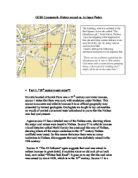
Picture of horse gin “our site”.
The circular stone structure at our site does
Relate to source 36. This is because it has
a hole in one corner of the ground
which most probably was a mineshaft.
The stone structure also has step like stones
to one side of it, which is similar
to source 36.
The evidence from source 36 suggests
that our Site was a horse gin, but we are
still not sure what it was used for.
Souce 13 says that the Horse Gin as used for pumping water from underneath the ground (from the shaft) in north Wales in 1698. Source 13 is not very reliable because its in the wrong time frame meaning that its to early, and is completely irrelevant to us. Secondly it is not very reliable because North Wales is a completely different area to the Bristol district and could use different equipment for different purposes.
Source 11 is completely different to the previous source because it states that Horse Gins were used for winding coal, instead of pumping.
Source 14 is also a useful source because it goes on to tell you that a horse gin acts as a winding engine and it uses horse power for the pumping and pulling up coal. This source is a reliable one because it is a source from the “British Social and Economic History” by P F speed.
Horse Gin Conclusion
The evidence suggests that Horse Gins were either used for pumping water from underground or for winding in coal from the mineshaft. Horse Gins used horsepower and pulled in coal and even miners from the mineshaft.
HORSE GIN
Pumps water Winding engine for coal and
perhaps people
Horse power
After looking at the evidence, I don’t agree that there were 2 Mineshafts at our site at Scotch Horn, but only 1 shaft instead.
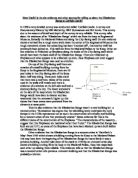
I believe this because I only saw one shaft at our site, which was located in the corner of the horse gin. Also source 11 “the 40 fathoms” says that many of the mines in Nailsea had only one shaft, so it’s likely that the one at scotch horn also had one shaft. Source 11 is reliable because it goes in to a lot of detail what the mines were like in Nailsea, but I doesn’t say when it was written or who wrote it, so it may also be unreliable. The reconstruction on source 36 has a diagram of the horse gin and it shows only one mineshaft in it.
Picture of a mineshaft, source 36
The mineshaft is based in between 2
large wooden beams and was used
for the miners to access the coal from
beneath the ground.
The depth of mine shafts varied, some
were50-90 ft deep where as some
were 240ft deep such as the
“40 fathoms” (1 fathom =6ft).
2 mineshafts conclusion
Even though there is little evidence about mineshafts, there is no evidence that agrees with any mines having 2 mine shafts, but only evidence that points to it having one shaft.
- Part 4, “what was the tower at are site used for”?
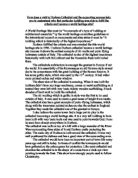
The tower at our site, at scotch horn may have been a pumping house. This is because on source 36 it shows a picture of a pumping house at elm colliery and did look similar to the tower at our site. The tower looked similar because it is a tall narrow building, with an archway, which looked like windows. These windows look familiar to the ones in source 36, source 36 shows that beams came out of the windows of the pumping house and were led down to the horse gin. The ruined building at scotch horn also has several holes in the wall, which also, according to source 36, had large beams coming from them. As said previously, source 36 is a Reconstruction by David Lambert and may be unreliable.
There is also another source (source 24) which suggests that it is a pumping house because it explains about pumping arrangements at the elm colliery. It has a listed diagram of different equipment including pumping equipment, and where they were positioned. This source may be reliable because it backs up source 36, which again talks about elms colliery. This source may not be reliable because it is also a reconstruction and it has no key or author written on it.
Source 36- picture of pumping house
The building is a tall arched building
Similar to our site. The picture
Shows a large boiler to one side, Of
the tower which Has no resemblance
to our site. The windows are very
similar to our site because the patter
is the same.
Overall this building has the correct
Shape and structure to the ruin at our
Site. Lack of evidence.
Alternatively our site could have instead been a winding house.
The site could have been used as a winding house because source 36 has a picture of a winding house, which has some familiar features on it, such as it has a wheel in the wall. This wheel went through the wall and at our site there is a large groove shaped indentation, which may have well been where the wheel was. Secondly this picture on source 36 has a chimney to one corner of it, our site looked as if it also had a chimney due to the ruined shape spout to one corner. Otherwise this picture has nothing else similar to the building at our site because the shape is completely different to the picture in source 36, the building is tall and not a small rectangle shape like the picture of the winding house, source 36.
As said previously source 36 may not be reliable because it is a reconstruction and therefore may be completely different.
Source 11. The 40 fathoms says that “the tower behind the ivy was a winding house for the mine, similar to the one at scotch horn playing fields”. This source may not be reliable because it had no dates or authors on it at all, but the source does sound interesting and has a lot of detail. I think this source is crucial because it says directly what the tower at scotch horn was used for, but it still may not be very reliable. Source 5 is also a useful source because it is a plan of the Nailsea glassworks produced in 1870. This building at scotch horn is labelled a “coal winding house”. This source may be reliable because it is an official plan of the Nailsea glassworks and it is labelled with a key. This source may not be reliable because in my view it is poorly annotated and it has no author.
Source 25 is also interesting because it is the winding arrangements of at elms colliery and it shows the equipment used in the winding house. This source is reliable because it is an official plan of the winding arrangements at elms colliery. However this source may not be reliable because it has no dates, no authors, and it is very brief like the plan of the Nailsea glassworks.
Conclusion for what the tower was used for.
The evidence suggests that there is more suitable (stronger) evidence that points towards the tower being a winding house. I think the tower was most probably used as a winding house but it could have been used for both? Judging on the size of the tower, I doubt it would be able to fit all of the pumping and winding equipment in.
- Part 5,“All in use at the same time”?.
The Horse gin and the engine house were not in used at the same time; I think this because on source 2 there is a map of Nailsea glassworks, late 1830’s. This source shows that there is a circular structure where our site is, this was most probably the horse gin, but there was no sign of the tower in this source. This source is reliable because it is an official plan of the Nailsea glassworks belonging to Messrs Lucan Cothupe & Coin the late 1830’s. However this source is poorly annotated and has no detail, it is just very brief and has a vague date, it doesn’t have any labels or keys on it.
Source 4 is very similar to the previous source and it proves that the Horse gin and the engine house were not in use at the same time because the map seems to have half a tower and no horse gin on it. This may suggest that the tower was in development and was being built or rebuilt, we wont no though because of no date on this source. This source is not very reliable because it has no date, no author or no title and it is poorly annotated. Source 5 also says that the tower was in 1870 but the horse was not.
Conclusion, “ In use at the same time”?
The evidence suggests that the Horse gin and the engine house were not used at the same time. The sources say that the horse gin or the tower could have been built at different periods and eventually used at the same time.
- Part 6, “there are no problems explaining the glass house pit”.
There are many problems explaining our site for example may pieces of evidence were not reliable either because they were wither poorly annotated, given a vague date or had no author. The evidence is mainly contradictory and could be fake or incorrect. Plans such as the Glasswork plans are poor because they don’t have very good keys, if any. Reconstruction’s such as source 36 can seem interesting and helpful but it could also be a poor reconstruction, and is in my view. Evidence was in small quantities for several questions such as, “ It was a pumping house”, and I couldn’t find much information about it at all, apart from source 36 which is a reconstruction.
The evidence its self may not be to blame for problems. This is because the site is not in great condition and various clues could have been taken away when Tesco was built, leaving us with various answers that cannot be explained.
There is also a lot of puzzling features at our site for example the large groove in the wall, which was most probably where the wheel went for the winding, but we can not be sure of that still. There were a few holes in the wall about 3-4 inches deep. These could have been used for large wooden beams, which led down to the horse gin, but we won’t know because of a lack of evidence in this field. There were step like stones on the side of the horse gin, which I have no idea what they were used for and there is no evidence suggesting anything to do with steps. I think they may have been used for a helpful access to the mineshaft, which is in the horse gin.
The chimney was tiered and had an archway on it, I don’t know why the chimney would need to be tiered or have an archway on it and there is no evidence saying why.
Conclusion.
I agree with the lack of helpful evidence because there is a lot of evidence but most of it is irrelevant and does not help at all. If there were more useful evidence then maybe we would be able to answer the puzzling features. I also agree with our site being in bad condition. I believe this because the tower is only in a basic form at the moment, it only has the foundation left and there is nothing left inside, it isn’t protected and is vulnerable to vandalism. Someone could mistake it for some sort of medieval jail. I also blame Tesco in a way because they should not of taken valuable pieces of history away from the site.
I don’t agree with that fact that some of the evidence is fake, this is because at the time someone would realise it was fake and it wouldn’t of been published if it was fake.
- Question 2, “Why were the interpretations different”?
There are various reasons why interpretations were different such as many different pieces of evidence were looked at. For example the interpretations about mine shafts in Nailsea are different because we looked at several different sources that has completely different views to each other, such as source 24. Source 24 is about the pumping arrangements at elms colliery, this source suggests that pumping took place, not winding. Where as source 11 “ 40 fathoms” suggests that the site was used for winding not pumping. Source 36, the reconstruction, suggests that is may have been used for a winding and pumping station.
The time frame of different sources could make a huge difference because after researching the site now we have more evidence, where as in the 1960’s there was less evidence. The author of a source may have different opinions to someone else’s view about a particular fact thus making 2 opposite sources. Guessing could have happened, such as reconstruction’s could not be as accurate as they could be and the author could of added something that may not of existed.
The Tourist board most probably made the facts basic and simple so that tourist’s could understand or the tourist board may of wrote a statement on coal mines in general or ones that are within this district (Bristol), but the scotch horn coal mine could be different to those elsewhere.
History Coursework- by Jason Phelan 113