Satellite navigation achieves its purpose because it can guide people to certain places accurately and satellite navigation devices can be used any where in the world.
How It Works
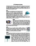
Satellite navigation works by using radio signals emitted by networks of satellites orbiting the Earth. Satellite navigations all work in generally the same way. There are three parts which include the network of satellites, a control station (somewhere on Earth that manages the satellites), and the receiver device people carry with them. Each satellite is constantly beaming out a radio-wave signal towards Earth. The receiver device “looks” for these signals and, if it can pick up signals from three or four different satellites, it can figure out your precise location.
This works by satellites staying in known positions and the signals travel at the speed of light. Each signal includes information about the satellite it came from and a time-stamp that says when it left the satellite. Since the signals are radio waves, they must travel at the speed of light. By noting when each signal arrives, the receiver can figure out how long it took to travel and how far it is from the sending satellite. With three or four signals the receiver can figure out exactly where it is on Earth.
Benefits
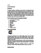
Satellite navigation has many benefits for example people don’t have to carry a map around with them all the time. Whilst in the middle of a journey someone getting a map out can be very annoying and disruptive to your journey. When someone is on their own this is even more of a problem as they would need to pull over and get a map out. With a satellite navigation system people will now be able to travel to a destination without needing to check a big map. Someone using a satellite navigation device can simply input their required destination and the satellite navigation device will be able to plan their route for them.
Limitations
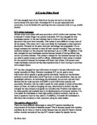
There can be some limitations of satellite navigation for instance people may need to carry a back up map and directions in case a satellite navigation system fails for some reason. For example, if someone is driving down a city street, the buildings may block the satellite signal preventing them from receiving position updates. If someone is hiking in the wilderness, their handheld satellite navigation receiver’s battery may die leaving them with no way to navigate.
Satellite navigation signals are not always completely accurate. Obstacles like buildings and trees can deflect the signal, causing someone’s position on the satellite navigation system screen to be off by as much as 100 feet. Atmospheric conditions may also affect satellite navigation accuracy.