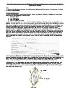
Table to show the different types and abundance of animal species in each quadrat:
Conclusion
Fucus Vesiculosus was the most abundant plant species found on the rocky shore. It is found on only the middle and upper shores. When it is submerged in water, the gas-filled air bladders on the fronds help to provide buoyancy so that they float freely on the surface of the water. This exposes their maximum area for photosynthesis.
When the tide is low, the exposure of this species to the sun and wind promotes desiccation. However, the entire surface of Fucus Vesiculosus is covered by a thick layer of mucilage which helps to prevent desiccation at low tide. It also reduces colonisation by epiphytic organisms.
Fucus Vesiculosus is not found on the lower shore for many reasons. Because it is a plant species, it needs to photosynthesise in order to respire. The photosynthetic pigments present include chlorophylls a and b. These pigments are green but are masked by large quantities of the brown pigment fucoxanthin. Fucoxanthin absorbs blue and green light. Although these wavelengths of light penetrate seawater much more effectively than red and yellow light, they cannot penetrate the water enough for it to be absorbed by the plant. This is because although Fucus Vesiculosus has bladders to provide buoyancy, the constant wave action at the lower shore would keep the fronds submerged in water for most of the day. Also, the air bladders are intolerant to constant and aggressive wave action that occurs on the lower shore. This is also a reason why Fucus Vesiculosus is not found in the splash zone.
The results showed that Fucus Vesiculosus is found from 20m from the low tide mark up to 80m. This suggests that the middle shore starts at 20m up-shore from the low tide mark.
Fucus Serratus is known to be found on the lower shore. This is because this species is very intolerant of desiccation so by situating itself on the lower shore ensures that it is not in direct contact with the wind and sun for most of the day, therefore reducing desiccation. When the species is exposed during low tide, only the top surface dries out because of the flattened frond.
By looking at the distribution pattern of this species suggests that the lower shore ends at 30m away from the low tide mark.
The third most abundant plant species found on the rocky shore was Coralline Officinalis. The results showed that this species was only found from 20m up-shore from the low tide mark. However, it is known that this species is found in all three zones on the rocky shore (upper, middle and lower shores). A reason for there being none of this species before 20m is that they tend to be most abundant on exposed coasts. This investigation was conducted on a fairly sheltered coast so this may have effected the distribution of Coralline Officinalis.
The results suggest that, like the Fucus Vesiculosus, the boundary between the lower and upper shore is 20m away from the low tide mark.
Flat periwinkles are found on the middle shore because they rely on the humidity under Fucus, on which they also feed. They breathe using gills so they can only respire out of water for a short period of time. Therefore, by situating on the middle shore, ensures that they are not exposed for too long during the day.
The results show that flat periwinkles were also found beyond 60m away from the low tide mark. This is the upper shore. The reason for these periwinkles being found here is that the young tend to migrate up the shore so they are in less competition with other periwinkles.
Rough periwinkles occur on the upper shore. This is because they have a high temperature tolerance so they are not affected by the constant exposure to the sun. Organisms living on the upper shore are only submerged in water for a short period of time during the day. Periwinkles have gills that can absorb air so they can remain out of water for up to one month. Also, fertilised eggs are retained within the body to hatch, and fertilisation is internal. These processes allow reproduction to take place without the need for submersal. Therefore, the upper shore is an ideal habitat for rough periwinkles.
As the results show, limpets are found in the upper, middle and lower shores. They have adaptations which allow them to live in any zone on the rocky shore. They adhere to rock surface by suction of muscular foot and chemicals. They rotate their shell to grind into the rock for a closer fit. At high tide, foot clamps shell onto rock to prevent desiccation. At low tide, they lower their metabolism.
These results provide enough information to estimate where the three zones on the rocky shore begin and end. By looking at the presence and absence of the organisms found, it suggests that the lower shore starts at the low tide mark and finishes 20m away from this mark. The middle shore starts at the 25m mark and ends at the 45m mark. Beyond 45m is the upper shore.
This investigation aided the coursework investigation as it highlighted the areas where Fucus Vesiculosus would be found, ie the middle and upper shore.