The Drainage basin
There are many different types of drainage basin all possessing different features, problems and positive points.
Trellised drainage patterns
These tend to develop where there is strong structural control upon streams because of geology in such situations channels align them selves parallel to structures in the bedrock with minor tributaries coming in at right angles. This only happens in rocks or any other very hard material because with any soft material the water would work its way through the corners so over time they would no longer be right angles. It can also cause flooding around the area where more than one tributary meets the stream channel.
Deranged Drainage patterns
These drainage patterns are often found in areas recently disturbed by events like glacial activity or volcanic deposition. Over time, the stream will adjust the topography of such regions by transporting sediment to improve flow and channel pattern, large pools and mini reservoirs are found in this drainage pattern in the event of heavy rain this would respond quite well and quickly to the rain i.e. water would be taken out the basin quite quickly.
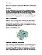
The drainage basin - Dendritic drainage pattern
Dentritic drainage patterns are typical of adjusted systems on erodable sediment or uniformly dipping bedrock. This is the most commonly seen one in britain as the water dosent flow round any corners as in deranged drainage pattern, it all flows towards the mouth reaching bigger and bigger tributaries (stream ordering)
Rectangular drainage pattern
Rectangular drainage patterns are areas with tectonic faults or bedrock joints that can cause streams to flow in a grid like fashion. These are also another ineffective drainage pattern when it experiences serious rain because the water once it has reached over a high point the water instead of following the grid like pattern it will find shortcuts and flow over the land as well as its original course.
Parallel drainage patterns
Parallel drainage patterns are ones where the water flows over areas with a steep relief or flows over non cohesive materials this is quite an effective basin except that there are not normally that many smaller tributaries leading to them they are all mostly larger stream channels
Storm hydrographs
Here we can see that the storm arrives then it takes some time for the water to pick up speed and velocity (lag time) this may be because when the water is in the tributary rivers it is not nessicarily flowing towards the stream channel it is flowing at right angles to it so in a storm with this type of basin the floods might affect the people living very close by as well as people further down stream. Also severe flooding might occur at the base of each tributary as it reaches the channel mouth as the water is coming down with such speed that it starts to erode at the points x and although rivers naturally meander it doesn´t naturally turn at right angles.
With this drainage basin there aren´t that many sharp corners so the water is going to be able to flow quite easily to the stream channel but this is slowed down by the large pockets of water at certain stages down the stream channel. These pockets are like small reservoirs and can contain a certain amount of water reducing the likely hood of flooding and also increasing the lag time and the rise time As these basins are formed by glacial movements the sides are normally quite steep and there is often no worry of flooding .
Also the peak discharge will not be that high because the water isnt reaching the stream channel all at once it is being eased in so if prolonged rain occurred then yes the water level would increase quite quickly but with just one storm there is a longish lag time and a gentle increase of the water level.
(Dentritic basin)
This is the most commonly seen basin around our area the lag times for this type of basin vary (more than all other basins) because there are many differing types of surface and slopes for the water to travel down. But they are mostly quite quick or medium. The rise time is also quite quick too but again if the rain is persistent then yes flooding is seen further down stream but if it is just a storm then the land can absorb most of the water
(rectangular basin)
Rectangular drainage basin is much the same story, the water is having to work its way through a complicated network of tributaries before reaching the stream channel. Therefore the lag time will be quite large but we also have to consider the type of surface the water is flowing over, and this type of basin is normally found on rocks and other hard surfaces so although the water will have to travel further it will be travelling much faster, which shortens the lag time and also shortens the rise time so the discharge is going to be quite steep because the water will arrive at the stream channel quite suddenly. Also because of the surface the rock is on the decreasing side for discharge will be quite steep too because the water can travel quite quickly out of the basin too. But this creates another problem that is flash floods because the water rises so much so quickly. I.e. the water will rise and fall quickly but will breech the bankful discharge, the peak discharge will be higher in a basin like this, than one like a dentritic basin in bad weather because the water all arrives all at once instead of being spread out over a few days
Storm hydrographs
(parallel basins)
These respond very quickly to storms and persistent rain as the water is transported straight to the stream channel flowing the same direction as it the lagtime is very short for this but flooding isnt experienced here unless there is a parallel basin further up stream as all the water is transported out of the way immediately.
But by analyzing these I am only half way to answering the essay title because there is much more fluvial language that I have yet to use.
There are many other natural factors which influences the mains channel and its response to rain fall.