1.5 Expectations:
This report is going to analyze different geological aspects that refer to the zone of Lake District.
In reference to physical geography, this report is going to investigate about the location of Lake District, its geological history, and its past glacial activity.
Lake District is a zone full of mountains which makes population settlement difficult because of its high altitude environment.
The economic aspects which will be discussed about are linked to the relief of the zone and the effects they have, the few number of economic activities and the most important economic sources of the zone, such as agriculture, tourism and mineral extraction.
2.0. Methods:
2.1. Primary Data:
2.1.1. Primary data are given by the observation of physical and human geography of Lake District or through interviews to people that come from the zone or pictures that present the landscape or the activities developed in the area.
2.2. Secondary Data:
2.2.1. Thanks to secondary data sources, geographic features will be examined in more detail. These sources are needed to make the study of the location more complete, thanks to information found on internet or on textbooks (such as graphs, pictures or statistics)
4.0. Analysis
4.1. Relief of the lands:
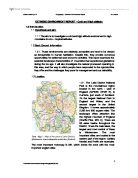
4.1.1. As the map shows, mountains and relief are located in particular in the central part of the region. The relief is between 100 meters and 1000 meters,
while the coast is at sea level. In the zone there are 214 fells: the tallest is Scafell Pike (978 meters). There are also 1 major lakes; many of them take the same pattern as the fells, so they form a kind of circle (radial pattern). [Wainwright 2010]
Relief characteristics represent challenges for human habitation and resource development. In fact, agriculture is less developed because it's difficult to exploit the ground as much as possible and Industries are located in the coasts. Furthermore there are not efficient and fast mains of transport because of the high altitude environment.
Regarding the resources, their development could be slowed because of the unsteady of land relief.
4.2. Climate:
4.2.1 The climate of Lake District is not temperate. The region has a very high rainfall, expecially in the centre, near the Sprinkling tarn. The rainfall is between 1000 mm and 2500 mm. As shown in text-fig.5, the period of maximium rainfall is in Dicember. Thanks to the maritime climate, there are moderate temperature variations during the year. The temperature in January is cold, expecially in the middle part (2°C) (in comparison with Moscow, that is located at the same latitude, the temperuture in the Lakes is not so cold). Also during the summer the temperature is low: while in the centre there could be a temperature of 10 - 14 °C, in the coast there could be 4 - 16 °C because of the proximity to the sea. The region is very windy and the fog is common at any time of the year.
4.3. Population
4.3.1. The zone of Lake District has not a big density. The most populated part is the external one ( around 10 - 150 persons per sq. Km), while in the centre there is a population density of less than 10 persons per sq. Km. The factors responsible for a low density of the population are relief, cold temperature, rainfall, inaccessibility, human discomfort, the fact that it is a desolate region, the lack of important industrial activity and of important energy sources.
4.4. Glacial Environmental:
4.4.1. About 2 million years ago glaciers and ice sheets developed because the climate became colder. Lake District has a glacial history that took place in 500 million years that contributed to form the current landscape of the zone.
Between a Glacial period and another one there have been episodes called Interglacials; there may have been about 10 climatic oscillations. The advance and retreat of glaciers caused the mountainous landscape of Lake District. After the last glacial episode, Holocene began gray -brown forest soils and developed beneath mature oak forest at low levels while Rankers formed. In the same period many basins were filled with peat.
4.5. Agriculture:
4.5.1. Agriculture and farming (especially of sheep) are two kinds of industry that developed in the region, even if the glacial features of the zone decrease the areas that may be used for this activity. Furthermore, relief and climate create limits to the developing of this kind of industry and create a lack of types of animals.
Agricultural lands are used first of all for Hill farming, silage and dairy farming. Hill farming is a system that uses grazing animals as sheep. Recently there have been problems: hill farming is not always because the land is marginal. Foot and mouth disease caused some problem to the sheep movement and the sale. By the way, there are also improvements: new breeding stock were made to improve quality and quantity of meat and wool. Sheep farming is important to the economy of the zone, but also in order to preserve the landscape of the region.
4.6 Mineral extraction:
4.6.1. In the zone of Lake District the mining industry provides for just 1 % of the whole employment but it provides for jobs. it is also needed to ensure the continued maintenance of the traditional Lakeland vernacular.
Mineral extractions have taken over 400 years. Lead and copper were being extracted before 1500. Mines were created to exploit mineral veins, which filled cracks in between the surrounding rocks. The most important mines were Greenside lead and silver mine, Borrowdale graphite (where the mining of graphite is very important for the growth of the industry of the pencil industry of Keswick) and Coniston copper mines. In 1995 the opened.
Recently, mining create environmental issues because of its waste and this represents a challenge for resource development; but this zone is a National Park, so it has to preserve the environment as best as possible.
4.7. Tourism:
4.7.1. Lake District National Park was born in 1951 to encourage people to keep in contact with nature and to satisfy nature lovers.
Tourism in this area continues unrelentingly to grow, and currently it has about 8 million visitors every year. But tourism in Lake District dates back to 1698, when lots of people discovered the pleasure of the journey. the area is reserved for tourists that want to enjoy themselves with expeditions and sport activities and for people that want to keep in contact with nature. Lots of factors let the increasing of the tourists as the increase in car ownership - flexibility or the use of the domestic equipment. Furthermore the area has become more accessible. In recent years the average wages have increased, in favor of tourism activities that the majority of the population can afford. The footpath erosion is a problem for the tourism; in fact it reduces the number of visitors, limits car parking, forces the visitors to take paths that may be damaging.
4.8. Sustainability:
4.8.1. The idea of the Sustainable development is that the quality of life is influenced by social, economic and environmental factors. In this regard, the Lake District Sustainable Development Fund supports the National Park, considering new ways of living and working. One of the aims, for example, is to find energy efficiency matters for community buildings. It has to consider ways of economic development by increasing tourism, mineral extraction, agriculture and farming, without causing environmental issues.
Regarding tourism, for example, the society is trying to reduce the number of tourists that visit the areas suffering from lakeshore erosions in order to help plants to grow again. This is why the Lake District Sustainable Development Fund is going to reduce pollution in water and to limit the erosion through retaining walls along the lakeshore.
5.0 Conclusions:
5.1. In the section ‘’Analysis’’ I went through the topics mentioned in ‘’Espectations’’, studying the different geographic aspects of Lake District. The landscape is dominated by mountains and hills, especially in the central part, which present a particular environment because of the glacial and geological history of the zone. The altitude causes a hard climate, difficult mains of transport and different kinds of discomford for human life. The economy of the area is based on agriculture, sheep farmning and tourism. The local authorities are going to solve issues linked to pollution, erosions or energy in order to advance the National Park.
6.0. Evaluation
6.1. In order to support a large number of information, many sources were analyzed. Unfortunately there are not many info about a topic, while there is a big amount of data regarding other points. There is a lack of primary data such as personal pictures or interviews to people who live in the zone, but there are graphs and maps found on internet that help the understanding of the topics.
5.0 Bibliography:
- Collins 2005
- http://en.wikipedia.org/wiki/Lake_District
- http://www.edina.ac.uk/learning/emapscholar/casestudies/.../StudentGroupA.doc
-
- http://www.edina.ac.uk/learning/emapscholar/casestudies/.../StudentGroupA.doc
-
-
Codrington 2009, ''Planet Geography'', 6th edition.