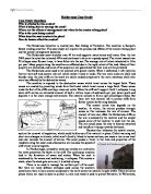
A solution to prevent costal erosion from happening so drastically is to put sea defences into place. However, this is very expensive and difficult to do and can often cause environmental damage and worse problems further along the coastline can occur, for example the Holderness Coast. Mappleton’s local council decided it would be best to build rock groynes which would trap the sand and increase the size of the beach below the cliff protecting the town so that the process of erosion would be slower. On the other hand, this created problems further down the coast and the groynes aided the costal erosion of many farms south of Mappleton. We study coasts so we are able to invent new ideas and strategies which will be able to help protect the coastal environment and its surrounding areas as well as conserve marine ecosystems.
Another reason for studying the coast is so we are able to use the resources it provides for us. Due to recent technological developments, we are now able to use the sea and ocean to generate energy, for example electricity. Over the past forty years, there has been constant interest in harnessing tidal power. Initially, this interest focused on estuaries, where large volumes of water pass through narrow channels generating high current velocities. Engineers felt that blocking estuaries with a barrage and forcing water through turbines would be an effective way to generate electricity. This was proved by the construction of a tidal barrage at St. Malo in France in the mid 1960s, which still provides 90% of Brittany’s energy today. However, there are environmental concerns with building these types of barrages.
A different way of generating high amounts of electricity is to use offshore wind power because there are higher wind speeds available offshore, compared to on land. The offshore wind farm in Kent is the largest in the world, consisting of one hundred turbines and powering over two hundred thousand homes. Offshore wind farms are most effective on islands because they are more exposed by the sea and ocean, which create more winds.
An additional cause for learning about coastlines is so we can prepare for high sea levels due to the rapid melting of ice caps. Monitoring sea levels is important because if they rise too quickly, low-lying land all over the world will be lost due to severe flooding. By observing sea levels, we are able to accurately predict when flooding could occur and be prepared by evacuating people out before anything catastrophic happens.
We study coasts for a variety of reasons, but the main motive is so that we can be prepared for the disasters that the environment will present us with.